
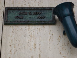
| Birth | : | 3 Sep 1878 Blue Earth, Faribault County, Minnesota, USA |
| Death | : | 18 Dec 1950 Polson, Lake County, Montana, USA |
| Burial | : | Chocksett Burial Ground, Sterling, Worcester County, USA |
| Coordinate | : | 42.4377000, -71.7555400 |
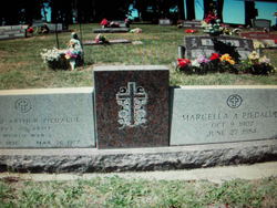
| Description | : | Polson Pioneer Passes Away Mary Elizabeth Hepp passed away Dec. 18 at Hotel Dieu Hospital in Polson at the age of 72 years. She was born Mary Elizabeth Roske at Blue Earth, Minnesota in 1878. She married Albert J. Hepp in May, 1897 at Butte. They have lived for many years in Lake county and Polson. Mrs. Hepp is survived by her husband Albert J. Hepp; three sons, Floyd and Ernest of Medford, Oregon and Jack of Burlingame, Calif.; two daughters, Marcella Piedalue of Ronan and Lillian Lambert of Lakeview, Oregon. One sister, Mrs. Minnie Palmer of Salmon, Idaho;... Read More |
frequently asked questions (FAQ):
-
Where is Mary Elizabeth Roske Hepp's memorial?
Mary Elizabeth Roske Hepp's memorial is located at: Chocksett Burial Ground, Sterling, Worcester County, USA.
-
When did Mary Elizabeth Roske Hepp death?
Mary Elizabeth Roske Hepp death on 18 Dec 1950 in Polson, Lake County, Montana, USA
-
Where are the coordinates of the Mary Elizabeth Roske Hepp's memorial?
Latitude: 42.4377000
Longitude: -71.7555400
Family Members:
Parent
Spouse

Siblings
Children
Flowers:


Nearby Cemetories:
1. Chocksett Burial Ground
Sterling, Worcester County, USA
Coordinate: 42.4377000, -71.7555400
2. Hillside Cemetery
Sterling, Worcester County, USA
Coordinate: 42.4410000, -71.7492570
3. Oak Hill Cemetery
Sterling, Worcester County, USA
Coordinate: 42.4417000, -71.7493973
4. West Cemetery
Sterling, Worcester County, USA
Coordinate: 42.4514100, -71.7651400
5. Fairbank Burial Ground
Sterling, Worcester County, USA
Coordinate: 42.4152600, -71.7320000
6. Cookshire Cemetery
Sterling, Worcester County, USA
Coordinate: 42.4108500, -71.7734800
7. Saint John's Cemetery
Lancaster, Worcester County, USA
Coordinate: 42.4328003, -71.6977997
8. Reservoir Pines Cemetery
Clinton, Worcester County, USA
Coordinate: 42.4084900, -71.7109700
9. Thayer Cemetery
Lancaster, Worcester County, USA
Coordinate: 42.4578500, -71.7024400
10. Legg Cemetery
Sterling, Worcester County, USA
Coordinate: 42.4070020, -71.7986150
11. Woodlawn Cemetery
Clinton, Worcester County, USA
Coordinate: 42.4185982, -71.6889038
12. Saint Lukes Cemetery
West Boylston, Worcester County, USA
Coordinate: 42.3833008, -71.7568970
13. High Plains Cemetery
West Boylston, Worcester County, USA
Coordinate: 42.3889008, -71.7972031
14. Middle Cemetery
Lancaster, Worcester County, USA
Coordinate: 42.4491997, -71.6757965
15. Parker II Cemetery
Princeton, Worcester County, USA
Coordinate: 42.4451900, -71.8370600
16. Old Settlers Burial Yard
Lancaster, Worcester County, USA
Coordinate: 42.4488754, -71.6742706
17. North Village Cemetery
Lancaster, Worcester County, USA
Coordinate: 42.4724998, -71.6778030
18. Old Common Burial Ground
Lancaster, Worcester County, USA
Coordinate: 42.4426700, -71.6645300
19. Beaman Cemetery
West Boylston, Worcester County, USA
Coordinate: 42.3649590, -71.7803600
20. Eastwood Cemetery
Lancaster, Worcester County, USA
Coordinate: 42.4417000, -71.6528015
21. Mount Vernon Cemetery
West Boylston, Worcester County, USA
Coordinate: 42.3634650, -71.7804030
22. Saint Leo Cemetery
Leominster, Worcester County, USA
Coordinate: 42.5153008, -71.7472000
23. Pine Grove Cemetery
Boylston, Worcester County, USA
Coordinate: 42.3582993, -71.7431030
24. Saint Cecilias Cemetery
Leominster, Worcester County, USA
Coordinate: 42.5166800, -71.7331900