
Mary F. “Polly” Hall Mooneyham
| Birth | : | 16 Feb 1838 Tennessee, USA |
| Death | : | 5 Jan 1920 USA |
| Burial | : | Dean Road and Manor Road Cemetery, Scarborough, Scarborough Borough, England |
| Coordinate | : | 54.2843690, -0.4184140 |
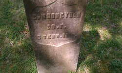
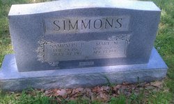
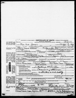
| Description | : | Daughter of Benjamin Hall and Sarah (Teeters) Hall. Sister of Nancy Jane (Hall) Simmons, William Hall, Minerva Hall, Patience Hall, Sarah Hall, Cary Emeline Hall, Martha C. Hall, Benjamin Hall, Susan Ann (Hall) Hale, Jacob Hall, and M. M. Hall (female). Wife of William Calvin Mooneyham. Mother of Mary Mance (Mooneyham) Simmons, W. T. S. [William Travis Simmons?] Mooneyham, Eleanor Mooneyham, Eva "Evie" (Mooneyham) Angel, Nettie Mooneyham, and Josie E. Mooneyham. Updated July 21, 2011. |
frequently asked questions (FAQ):
-
Where is Mary F. “Polly” Hall Mooneyham's memorial?
Mary F. “Polly” Hall Mooneyham's memorial is located at: Dean Road and Manor Road Cemetery, Scarborough, Scarborough Borough, England.
-
When did Mary F. “Polly” Hall Mooneyham death?
Mary F. “Polly” Hall Mooneyham death on 5 Jan 1920 in USA
-
Where are the coordinates of the Mary F. “Polly” Hall Mooneyham's memorial?
Latitude: 54.2843690
Longitude: -0.4184140
Family Members:
Spouse
Children
Flowers:


Nearby Cemetories:
1. Dean Road and Manor Road Cemetery
Scarborough, Scarborough Borough, England
Coordinate: 54.2843690, -0.4184140
2. Greyfriars Abbey
Scarborough, Scarborough Borough, England
Coordinate: 54.2850360, -0.3950300
3. Quaker House Church
Scarborough Borough, England
Coordinate: 54.2844280, -0.3941730
4. St. Mary's Churchyard
Scarborough, Scarborough Borough, England
Coordinate: 54.2864850, -0.3936260
5. Woodlands Cemetery and Crematorium
Scarborough, Scarborough Borough, England
Coordinate: 54.2766640, -0.4428030
6. Scarborough Castle
Scarborough, Scarborough Borough, England
Coordinate: 54.2875810, -0.3895485
7. St Laurence Churchyard
Scalby, Scarborough Borough, England
Coordinate: 54.2988160, -0.4507520
8. St. John the Baptist Churchyard
East Ayton, Scarborough Borough, England
Coordinate: 54.2508900, -0.4792900
9. St Martin Churchyard
Seamer, Scarborough Borough, England
Coordinate: 54.2361500, -0.4437100
10. Cloughton Church Cemetery
Cloughton, Scarborough Borough, England
Coordinate: 54.3322500, -0.4511900
11. St. John the Baptist Churchyard
Cayton, Scarborough Borough, England
Coordinate: 54.2346470, -0.3805180
12. St Peter Churchyard
Hackness, Scarborough Borough, England
Coordinate: 54.3012880, -0.5127850
13. Cayton Cemetery
Cayton, Scarborough Borough, England
Coordinate: 54.2314030, -0.3755910
14. St Matthew Churchyard
Hutton Buscel, Scarborough Borough, England
Coordinate: 54.2426410, -0.5071200
15. St. Helen’s & All Saints Churchyard
Wykeham, Scarborough Borough, England
Coordinate: 54.2372000, -0.5212000
16. St Peter Churchyard
Langdale End, Scarborough Borough, England
Coordinate: 54.3065050, -0.5557030
17. St John The Evangelist Churchyard
Folkton, Scarborough Borough, England
Coordinate: 54.2020400, -0.3865200
18. Flixton Cemetery New
Folkton, Scarborough Borough, England
Coordinate: 54.2006600, -0.3934700
19. St Margaret Churchyard
Harwood Dale, Scarborough Borough, England
Coordinate: 54.3470030, -0.5238540
20. St. Peter's Churchyard
Willerby, Ryedale District, England
Coordinate: 54.1984200, -0.4558500
21. Staintondale Churchyard
Staintondale, Scarborough Borough, England
Coordinate: 54.3752645, -0.4795295
22. All Saints Churchyard
Brompton-by-Sawdon, Scarborough Borough, England
Coordinate: 54.2262550, -0.5549320
23. All Saints Church Cemetery
Brompton-by-Sawdon, Scarborough Borough, England
Coordinate: 54.2223100, -0.5500900
24. St Margaret Churchyard (Ruins)
Harwood Dale, Scarborough Borough, England
Coordinate: 54.3558170, -0.5365790