
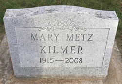
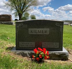
Mary Isabel Metz Kilmer
| Birth | : | 28 Feb 1915 Carroll County, Indiana, USA |
| Death | : | 10 Feb 2008 Monticello, White County, Indiana, USA |
| Burial | : | Brule Creek Cemetery, Spink Township, Union County, USA |
| Coordinate | : | 42.8346510, -96.7324350 |
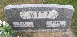
| Description | : | Mother of Dwain M.Wigner Wife of Frank Wigner Wilbur Kilmer ∼Mary I. Kilmer, 92, was the daughter of the Carl and Leam Heiny Metz. She resided in White and Carroll counties all of her life and was a graduate of Roosevelt High School in Monticello. She married Frank Wigner in 1933 in Carroll County. He preceded her in death. She married Wilbur Kilmer on July 5, 1951. He died August 31, 1983. Mrs. Kilmer had worked as a telephone operator at the Yeoman Telephone Co. for several years. She... Read More |
frequently asked questions (FAQ):
-
Where is Mary Isabel Metz Kilmer's memorial?
Mary Isabel Metz Kilmer's memorial is located at: Brule Creek Cemetery, Spink Township, Union County, USA.
-
When did Mary Isabel Metz Kilmer death?
Mary Isabel Metz Kilmer death on 10 Feb 2008 in Monticello, White County, Indiana, USA
-
Where are the coordinates of the Mary Isabel Metz Kilmer's memorial?
Latitude: 42.8346510
Longitude: -96.7324350
Family Members:
Parent

Spouse
Siblings
Flowers:


Nearby Cemetories:
1. Ahlsborg Lutheran Cemetery
Union County, USA
Coordinate: 42.8228000, -96.7612000
2. Pleasant Hill Cemetery Old
Spink, Union County, USA
Coordinate: 42.8588462, -96.7215592
3. Saint Mary Cemetery
Union County, USA
Coordinate: 42.8520584, -96.7877502
4. First Brule Creek Cemetery
Elk Point, Union County, USA
Coordinate: 42.7943993, -96.7069016
5. Pleasant Hill Cemetery
Spink, Union County, USA
Coordinate: 42.8741000, -96.6876000
6. Union County Poor Farm Cemetery
Union County, USA
Coordinate: 42.7649210, -96.7077580
7. Saint Paul Cemetery
Elk Point, Union County, USA
Coordinate: 42.7641983, -96.7061005
8. Dowlin Cemetery
Burbank, Clay County, USA
Coordinate: 42.7789001, -96.8107986
9. Richland Cemetery
Richland, Union County, USA
Coordinate: 42.7682991, -96.6624985
10. Gores Bluff Cemetery
Union County, USA
Coordinate: 42.8035069, -96.6260468
11. Olbue Lerseth Cemetery
Beresford, Union County, USA
Coordinate: 42.9281100, -96.7516100
12. Saint Agnes Cemetery
Vermillion, Clay County, USA
Coordinate: 42.7872009, -96.8499985
13. Nora Cemetery
Union County, USA
Coordinate: 42.9314003, -96.7061005
14. Saint Peter Greenfield Cemetery
Vermillion, Clay County, USA
Coordinate: 42.8608017, -96.8644028
15. Roseni Lutheran Church Cemetery
Beresford, Union County, USA
Coordinate: 42.9388000, -96.7639000
16. Union Creek Cemetery
Union County, USA
Coordinate: 42.8911018, -96.5863037
17. Rockfield Cemetery
Clay County, USA
Coordinate: 42.9397011, -96.8302994
18. Mount Hope Cemetery
Union County, USA
Coordinate: 42.8885994, -96.5667038
19. Westfield Township Cemetery
Westfield, Plymouth County, USA
Coordinate: 42.7510986, -96.5914001
20. Riverside Cemetery
Akron, Plymouth County, USA
Coordinate: 42.8367004, -96.5453033
21. Big Springs Cemetery
Big Springs, Union County, USA
Coordinate: 42.9379000, -96.6090000
22. Bluff View Cemetery
Vermillion, Clay County, USA
Coordinate: 42.7714000, -96.9056000
23. Clay Point Cemetery
Prairie Center Township, Clay County, USA
Coordinate: 42.8987700, -96.9065600
24. Saint Agnes Calvary Cemetery
Vermillion, Clay County, USA
Coordinate: 42.7715900, -96.9072100