
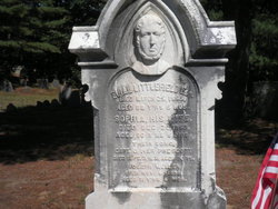
Mary Parker Perry
| Birth | : | 7 May 1745 Holliston, Middlesex County, Massachusetts, USA |
| Death | : | 29 Apr 1813 Holliston, Middlesex County, Massachusetts, USA |
| Burial | : | Haycombe Cemetery and Crematorium, Bath, Bath and North East Somerset Unitary Authority, England |
| Coordinate | : | 51.3703430, -2.4014760 |
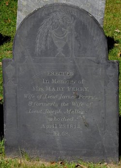
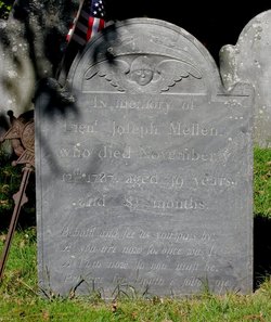
| Description | : | Holliston births: PARKER, Mary, d. Timothy and Keziah, May 7, 1744 [?]. [bp. May 19, 1745. CR1] [[w. Lt. Joseph Mellen Littlefield] May 7, 1745. PR17] Holliston marriages: MILLEN, Joseph and Mary Parker, May 12, 1763. * [Mellen, M.R.] Holliston deaths: MELLEN, Joseph, Lt., Nov. 12, 1787. [a. 49 y. 8 m. GR1] Holliston marriages: MELLEN, Mary, Mrs., and James Perry, int. Nov. 10, 1788. Holliston deaths: PERRY, Mary, w. Lt. James, "formerly" w. Lt. Joseph Mellen, Apr. 29, 1813, a. 68. GR1 |
frequently asked questions (FAQ):
-
Where is Mary Parker Perry's memorial?
Mary Parker Perry's memorial is located at: Haycombe Cemetery and Crematorium, Bath, Bath and North East Somerset Unitary Authority, England.
-
When did Mary Parker Perry death?
Mary Parker Perry death on 29 Apr 1813 in Holliston, Middlesex County, Massachusetts, USA
-
Where are the coordinates of the Mary Parker Perry's memorial?
Latitude: 51.3703430
Longitude: -2.4014760
Family Members:
Parent
Spouse
Siblings
Children

Flowers:


Nearby Cemetories:
1. Haycombe Cemetery and Crematorium
Bath, Bath and North East Somerset Unitary Authority, England
Coordinate: 51.3703430, -2.4014760
2. St Peter Churchyard
Englishcombe, Bath and North East Somerset Unitary Authority, England
Coordinate: 51.3640600, -2.4088700
3. St Michael and All Angels Churchyard
Twerton, Bath and North East Somerset Unitary Authority, England
Coordinate: 51.3809000, -2.3981000
4. Twerton Cemetery
Twerton, Bath and North East Somerset Unitary Authority, England
Coordinate: 51.3802500, -2.3836220
5. Locksbrook Cemetery
Lower Weston, Bath and North East Somerset Unitary Authority, England
Coordinate: 51.3845180, -2.3850300
6. Locksbrook St Saviour's Cemetery
Bath and North East Somerset Unitary Authority, England
Coordinate: 51.3867880, -2.3863380
7. St. Michael's Cemetery
Bath, Bath and North East Somerset Unitary Authority, England
Coordinate: 51.3859700, -2.3814500
8. Bath Union Workhouse Burial Ground
Bath, Bath and North East Somerset Unitary Authority, England
Coordinate: 51.3570889, -2.3773370
9. St. James' Cemetery
Bath, Bath and North East Somerset Unitary Authority, England
Coordinate: 51.3802000, -2.3722200
10. Holy Trinity Churchyard
Newton St Loe, Bath and North East Somerset Unitary Authority, England
Coordinate: 51.3820470, -2.4311300
11. Bath Union Workhouse Graveyard
Bath, Bath and North East Somerset Unitary Authority, England
Coordinate: 51.3584160, -2.3711140
12. Moravian Burial Ground
Bath, Bath and North East Somerset Unitary Authority, England
Coordinate: 51.3894150, -2.3798150
13. St Mary Magdalen Chapel
Widcombe, Bath and North East Somerset Unitary Authority, England
Coordinate: 51.3760486, -2.3643405
14. St Mary's Chapel, Queens Square
Bath, Bath and North East Somerset Unitary Authority, England
Coordinate: 51.3827790, -2.3649790
15. All Saints Churchyard
Weston, Bath and North East Somerset Unitary Authority, England
Coordinate: 51.3956850, -2.3881320
16. St James Old Burial Ground
Bath, Bath and North East Somerset Unitary Authority, England
Coordinate: 51.3798600, -2.3610100
17. Countess of Huntingdon's Chapel
Walcot, Bath and North East Somerset Unitary Authority, England
Coordinate: 51.3967020, -2.3907434
18. Saint Mark's Churchyard
Widcombe, Bath and North East Somerset Unitary Authority, England
Coordinate: 51.3766660, -2.3588010
19. Bath General Hospital Burial Ground
Bath and North East Somerset Unitary Authority, England
Coordinate: 51.3824715, -2.3614742
20. St. Mary de Stall Churchyard (Defunct)
Bath, Bath and North East Somerset Unitary Authority, England
Coordinate: 51.3813350, -2.3600353
21. Quaker Meeting House
Bath, Bath and North East Somerset Unitary Authority, England
Coordinate: 51.3823280, -2.3604380
22. All Saints Churchyard
Corston, Bath and North East Somerset Unitary Authority, England
Coordinate: 51.3857350, -2.4400372
23. Old Orchard Street Catholic Burial Vault
Bath, Bath and North East Somerset Unitary Authority, England
Coordinate: 51.3800370, -2.3579910
24. Bath Abbey
Bath, Bath and North East Somerset Unitary Authority, England
Coordinate: 51.3815310, -2.3586640