
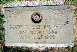
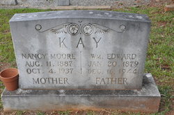
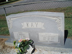
Mary Tea Kay Pickens
| Birth | : | 1 Nov 1884 Anderson County, South Carolina, USA |
| Death | : | 26 Aug 1966 Anderson County, South Carolina, USA |
| Burial | : | Sacramento County Cemetery, Sacramento County, USA |
| Coordinate | : | 38.5267900, -121.4233700 |
frequently asked questions (FAQ):
-
Where is Mary Tea Kay Pickens's memorial?
Mary Tea Kay Pickens's memorial is located at: Sacramento County Cemetery, Sacramento County, USA.
-
When did Mary Tea Kay Pickens death?
Mary Tea Kay Pickens death on 26 Aug 1966 in Anderson County, South Carolina, USA
-
Where are the coordinates of the Mary Tea Kay Pickens's memorial?
Latitude: 38.5267900
Longitude: -121.4233700
Family Members:
Parent
Spouse
Siblings
Children
Flowers:


Nearby Cemetories:
1. Sacramento County Cemetery
Sacramento County, USA
Coordinate: 38.5267900, -121.4233700
2. Russian Orthodox Cemetery
Sacramento, Sacramento County, USA
Coordinate: 38.5268800, -121.4244300
3. Sacramento County Veterans Memorial Cemetery
Sacramento, Sacramento County, USA
Coordinate: 38.5252838, -121.4239120
4. Sacramento County Hospital Cemetery
Sacramento, Sacramento County, USA
Coordinate: 38.5289300, -121.4239100
5. Saint Mary's Catholic Cemetery and Mausoleum
Sacramento, Sacramento County, USA
Coordinate: 38.5298900, -121.4261200
6. Tinh Xa Ngoc An Temple Columbarium
Sacramento, Sacramento County, USA
Coordinate: 38.5190200, -121.4159500
7. Elder Creek Cemetery
Florin, Sacramento County, USA
Coordinate: 38.5111008, -121.4169006
8. Sacramento Memorial Lawn Cemetery
Sacramento, Sacramento County, USA
Coordinate: 38.5146484, -121.4380341
9. Home of Peace Cemetery
Sacramento, Sacramento County, USA
Coordinate: 38.5137558, -121.4382782
10. Saint Rose Cemetery (Defunct)
Sacramento, Sacramento County, USA
Coordinate: 38.5208015, -121.4672012
11. East Lawn Memorial Park
Sacramento, Sacramento County, USA
Coordinate: 38.5612960, -121.4492760
12. Pho Minh Temple Columbarium
Sacramento, Sacramento County, USA
Coordinate: 38.5340100, -121.4769000
13. New Helvetia Cemetery (Defunct)
Sacramento, Sacramento County, USA
Coordinate: 38.5731600, -121.4639900
14. Saint Joseph Cemetery
Sacramento, Sacramento County, USA
Coordinate: 38.5574989, -121.4835968
15. Trinity Episcopal Cathedral Columbarium
Sacramento, Sacramento County, USA
Coordinate: 38.5705500, -121.4723770
16. Odd Fellows Lawn Cemetery and Mausoleum
Sacramento, Sacramento County, USA
Coordinate: 38.5585000, -121.5011000
17. Buddhist Church of Sacramento Nokotsudo
Sacramento, Sacramento County, USA
Coordinate: 38.5639300, -121.4978400
18. Masonic Lawn Cemetery
Sacramento, Sacramento County, USA
Coordinate: 38.5604720, -121.5032600
19. Sacramento City Cemetery
Sacramento, Sacramento County, USA
Coordinate: 38.5636864, -121.5009537
20. Sunset Hill Cemetery
Sacramento, Sacramento County, USA
Coordinate: 38.5608000, -121.5037300
21. California State Capitol
Sacramento, Sacramento County, USA
Coordinate: 38.5760994, -121.4931488
22. National Shrine of Our Lady of Guadalupe Crypt
Sacramento, Sacramento County, USA
Coordinate: 38.5704800, -121.5014400
23. Bellview Cemetery
Sacramento, Sacramento County, USA
Coordinate: 38.5153580, -121.3257446
24. Kim Quang Temple Columbarium
Sacramento, Sacramento County, USA
Coordinate: 38.5996600, -121.3904700