

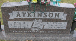
Max Harrison Atkinson
| Birth | : | 19 Sep 1915 Olean, Miller County, Missouri, USA |
| Death | : | 29 Jul 1990 Olean, Miller County, Missouri, USA |
| Burial | : | Holy Trinity Church, Witney, West Oxfordshire District, England |
| Coordinate | : | 51.7726500, -1.6142050 |
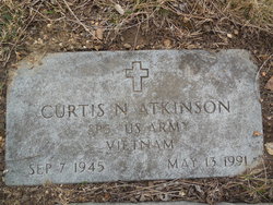
| Inscription | : | Married 5/29/1937 Parents of Carolyn Sue & Curtis Neil |
| Description | : | The Eldon Advertiser, July 1990 Well known auctioneer, Max H. Atkinson, 74, of Olean died Sunday, July 29, 1990 at Memorial Community Hospital in Jefferson City. He was born Sept. 19, 1915 in Olean and lived in that town his entire life. He was the son of Edward L. and Lola Harrison Atkinson. On May 29, 1937 he was married in Tuscumbia to Helen B. Serl, who survives at the home. Mr. Atkinson operated a private auction service and also was an auctioneer at the Olean Livestock Market for 32 years. He farmed and raised horses and cattle.... Read More |
frequently asked questions (FAQ):
-
Where is Max Harrison Atkinson's memorial?
Max Harrison Atkinson's memorial is located at: Holy Trinity Church, Witney, West Oxfordshire District, England.
-
When did Max Harrison Atkinson death?
Max Harrison Atkinson death on 29 Jul 1990 in Olean, Miller County, Missouri, USA
-
Where are the coordinates of the Max Harrison Atkinson's memorial?
Latitude: 51.7726500
Longitude: -1.6142050
Family Members:
Parent
Spouse
Siblings
Children
Flowers:


Nearby Cemetories:
1. Holy Trinity Church
Witney, West Oxfordshire District, England
Coordinate: 51.7726500, -1.6142050
2. Holy Rood Churchyard
Shilton, West Oxfordshire District, England
Coordinate: 51.7726519, -1.6142058
3. St. Britius Churchyard
Brize Norton, West Oxfordshire District, England
Coordinate: 51.7662000, -1.5667000
4. St. Britius Churchyard Extension
Brize Norton, West Oxfordshire District, England
Coordinate: 51.7660800, -1.5662600
5. St Nicholas Parish Church
Asthall, West Oxfordshire District, England
Coordinate: 51.8003600, -1.5850500
6. St. Peter's Churchyard
Alvescot, West Oxfordshire District, England
Coordinate: 51.7392910, -1.6046704
7. St Georges Churchyard
Kencot, West Oxfordshire District, England
Coordinate: 51.7407160, -1.6330900
8. St Oswald's Churchyard
Widford, West Oxfordshire District, England
Coordinate: 51.8067780, -1.6047160
9. Baptist Burial Ground
Burford, West Oxfordshire District, England
Coordinate: 51.8070150, -1.6338030
10. St Mary Churchyard
Swinbrook, West Oxfordshire District, England
Coordinate: 51.8072090, -1.5954540
11. St. John the Baptist Churchyard
Burford, West Oxfordshire District, England
Coordinate: 51.8096490, -1.6341730
12. Saint Mary's Churchyard
Black Bourton, West Oxfordshire District, England
Coordinate: 51.7360520, -1.5864600
13. Burford Cemetery
Burford, West Oxfordshire District, England
Coordinate: 51.8084000, -1.6489600
14. St. Mary's Churchyard
Westwell, West Oxfordshire District, England
Coordinate: 51.7886840, -1.6779678
15. St James The Great Churchyard
Fulbrook, West Oxfordshire District, England
Coordinate: 51.8153500, -1.6265430
16. St Peter's Churchyard
Filkins, West Oxfordshire District, England
Coordinate: 51.7358700, -1.6578250
17. Saint Matthew's Churchyard
Langford, West Oxfordshire District, England
Coordinate: 51.7209390, -1.6405280
18. St. Stephen's Churchyard
Clanfield, West Oxfordshire District, England
Coordinate: 51.7174060, -1.5911740
19. St. John The Evangelist Churchyard
Taynton, West Oxfordshire District, England
Coordinate: 51.8216040, -1.6621950
20. Saint Kenelm's Churchyard
Minster Lovell, West Oxfordshire District, England
Coordinate: 51.8000620, -1.5314550
21. St John The Baptist
Curbridge, West Oxfordshire District, England
Coordinate: 51.7764570, -1.5203140
22. Bampton Cemetery
Bampton, West Oxfordshire District, England
Coordinate: 51.7296400, -1.5490200
23. St. Mary the Virgin Churchyard
Bampton, West Oxfordshire District, England
Coordinate: 51.7278250, -1.5487270
24. St. Andrew's Churchyard
Eastleach, Cotswold District, England
Coordinate: 51.7465120, -1.7087670