
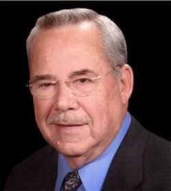
Melvin H. “Mel” Proctor
| Birth | : | 6 Dec 1933 Russellville, Cole County, Missouri, USA |
| Death | : | 26 Mar 2021 Jefferson City, Cole County, Missouri, USA |
| Burial | : | Enloe Cemetery, Moniteau County, USA |
| Coordinate | : | 38.5074997, -92.4741974 |
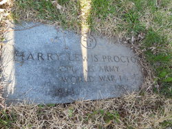
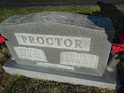
| Description | : | Melvin "Mel" H. Proctor, 87, of Jefferson City, MO, went home to be with his Lord and Savior peacefully in his home, in the early morning hours of March 26, 2021. Melvin was born on December 6, 1933, in Russellville, MO, to Harry and Nellie Proctor. He was the seventh of eight children in the Proctor household. He was married on September 24, 1955 in Jefferson City, Mo. to Virginia Lynn "Ginny" Guemmer, who preceded him in death on February 5, 2016. Melvin was a 1951 graduate of Jefferson City High School and was always proud to hail... Read More |
frequently asked questions (FAQ):
-
Where is Melvin H. “Mel” Proctor's memorial?
Melvin H. “Mel” Proctor's memorial is located at: Enloe Cemetery, Moniteau County, USA.
-
When did Melvin H. “Mel” Proctor death?
Melvin H. “Mel” Proctor death on 26 Mar 2021 in Jefferson City, Cole County, Missouri, USA
-
Where are the coordinates of the Melvin H. “Mel” Proctor's memorial?
Latitude: 38.5074997
Longitude: -92.4741974
Family Members:
Parent
Spouse

Siblings
Flowers:


Nearby Cemetories:
1. Enloe Cemetery
Moniteau County, USA
Coordinate: 38.5074997, -92.4741974
2. Belleville Cemetery
Russellville, Cole County, USA
Coordinate: 38.4970490, -92.4667150
3. Enon Cemetery
Russellville, Cole County, USA
Coordinate: 38.4888992, -92.4730988
4. Karnes-Carney-Henderson Cemetery
Burris Fork, Moniteau County, USA
Coordinate: 38.4992100, -92.5007510
5. Saint Michael Cemetery
Russellville, Cole County, USA
Coordinate: 38.5109300, -92.4429100
6. Evangelical Lutheran Cemetery One Acre
Russellville, Cole County, USA
Coordinate: 38.5175667, -92.4415817
7. Buckner Russell Cemetery
Cole County, USA
Coordinate: 38.5136900, -92.4359390
8. Van Pool Cemetery
Moniteau County, USA
Coordinate: 38.5372009, -92.4627991
9. Russellville Cemetery
Russellville, Cole County, USA
Coordinate: 38.5196991, -92.4366989
10. Trinity Lutheran Cemetery
Russellville, Cole County, USA
Coordinate: 38.5028000, -92.4317017
11. Karnes Cemetery
Corticelli, Moniteau County, USA
Coordinate: 38.5099700, -92.5247900
12. Campbell Cemetery
Cole County, USA
Coordinate: 38.4810982, -92.4297028
13. Blank Cemetery
Russellville, Cole County, USA
Coordinate: 38.5203018, -92.4180984
14. DeFoe Cemetery
California, Moniteau County, USA
Coordinate: 38.5416985, -92.5250015
15. Rock Enon Cemetery
Miller County, USA
Coordinate: 38.4668400, -92.5170700
16. Bruce-Lewis-McGahan Cemetery
Enon, Moniteau County, USA
Coordinate: 38.4667500, -92.5172100
17. Roark Cemetery
Russellville, Cole County, USA
Coordinate: 38.4696999, -92.4255981
18. Matheis Cemetery
Russellville, Cole County, USA
Coordinate: 38.4571800, -92.4491600
19. Barnhardt Cemetery
Lohman, Cole County, USA
Coordinate: 38.5537900, -92.4267100
20. Clibourn Cemetery
Russellville, Cole County, USA
Coordinate: 38.4760500, -92.3973500
21. Marney Family Cemetery
High Point, Moniteau County, USA
Coordinate: 38.5357900, -92.5614500
22. Jackson Chapel Methodist Church Cemetery
California, Moniteau County, USA
Coordinate: 38.4447900, -92.5286500
23. Yarnell Cemetery
California, Moniteau County, USA
Coordinate: 38.5189018, -92.5708008
24. Gray Cemetery
Moniteau County, USA
Coordinate: 38.4536018, -92.5456009