
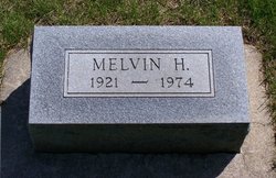
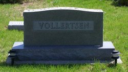

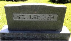
Melvin H Vollertsen
| Birth | : | 29 Oct 1921 Lorton, Otoe County, Nebraska, USA |
| Death | : | 13 Dec 1974 Syracuse, Otoe County, Nebraska, USA |
| Burial | : | St Peter and St Paul Churchyard, Scrayingham, Ryedale District, England |
| Coordinate | : | 54.0342510, -0.8826130 |
| Plot | : | Lot 157 # 4N |
frequently asked questions (FAQ):
-
Where is Melvin H Vollertsen's memorial?
Melvin H Vollertsen's memorial is located at: St Peter and St Paul Churchyard, Scrayingham, Ryedale District, England.
-
When did Melvin H Vollertsen death?
Melvin H Vollertsen death on 13 Dec 1974 in Syracuse, Otoe County, Nebraska, USA
-
Where are the coordinates of the Melvin H Vollertsen's memorial?
Latitude: 54.0342510
Longitude: -0.8826130
Family Members:
Spouse
Children

Flowers:


Nearby Cemetories:
1. St Peter and St Paul Churchyard
Scrayingham, Ryedale District, England
Coordinate: 54.0342510, -0.8826130
2. St Botolph Churchyard
Bossall, Ryedale District, England
Coordinate: 54.0375570, -0.9047540
3. St John the Evangelist Churchyard
Buttercrambe, Ryedale District, England
Coordinate: 54.0137300, -0.8812900
4. Howsham Churchyard
Howsham, Ryedale District, England
Coordinate: 54.0565520, -0.8755670
5. St. Mary's Churchyard
Sand Hutton, Ryedale District, England
Coordinate: 54.0183800, -0.9410700
6. St Michael Churchyard
Crambe, Ryedale District, England
Coordinate: 54.0744550, -0.8809390
7. St Andrew Churchyard
Bugthorpe, East Riding of Yorkshire Unitary Authority, England
Coordinate: 54.0108100, -0.8226900
8. St Peter Churchyard
Upper Helmsley, Ryedale District, England
Coordinate: 54.0044650, -0.9409770
9. St Mary Churchyard
Full Sutton, East Riding of Yorkshire Unitary Authority, England
Coordinate: 53.9897620, -0.8613700
10. Kirkham Priory
Kirkham, Ryedale District, England
Coordinate: 54.0826180, -0.8768470
11. St John the Baptist
Acklam, Ryedale District, England
Coordinate: 54.0451010, -0.8006330
12. St Lawrence Churchyard
Flaxton, Ryedale District, England
Coordinate: 54.0508680, -0.9624500
13. All Saints Churchyard
Foston, Ryedale District, England
Coordinate: 54.0775719, -0.9331510
14. St. Mary's Churchyard
Westow, Ryedale District, England
Coordinate: 54.0846190, -0.8406850
15. St. Mary's Churchyard
Gate Helmsley, Ryedale District, England
Coordinate: 53.9883720, -0.9481980
16. All Saints Churchyard
Low Catton, East Riding of Yorkshire Unitary Authority, England
Coordinate: 53.9769280, -0.9268720
17. Burythorpe Churchyard
Burythorpe, Ryedale District, England
Coordinate: 54.0752951, -0.7955984
18. St John the Evangelist Churchyard
Welburn (Malton), Ryedale District, England
Coordinate: 54.1008850, -0.8985440
19. St Mary Churchyard
Warthill, Ryedale District, England
Coordinate: 53.9887610, -0.9714450
20. All Saints Churchyard
Kirby Underdale, East Riding of Yorkshire Unitary Authority, England
Coordinate: 54.0166200, -0.7677100
21. St Martin Churchyard
Fangfoss, East Riding of Yorkshire Unitary Authority, England
Coordinate: 53.9704970, -0.8324690
22. St Martin Churchyard
Bulmer, Ryedale District, England
Coordinate: 54.0997510, -0.9317700
23. St. Margaret's Churchyard
Huttons Ambo, Ryedale District, England
Coordinate: 54.1066490, -0.8490640
24. St. Edith Churchyard
Bishop Wilton, East Riding of Yorkshire Unitary Authority, England
Coordinate: 53.9862300, -0.7838500