


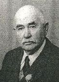
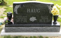
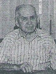
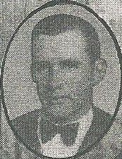
Melvin Joseph Haug
| Birth | : | 22 Dec 1924 Nemaha County, Kansas, USA |
| Death | : | 30 Aug 2011 Seneca, Nemaha County, Kansas, USA |
| Burial | : | Saint Marys Cemetery, Saint Benedict, Nemaha County, USA |
| Coordinate | : | 39.8866997, -96.0982971 |
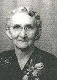
| Description | : | Melvin Joseph Haug, 86, of Seneca, KS, died on Tuesday, August 30, 2011, at Life Care Center in Seneca. Melvin was born December 22, 1924, the youngest son of John B. and Philomena (Koelzer) Haug, on the family farm three miles north of Seneca. He attended school at St Benedict and then began farming the family farm, where he lived all of his life until moving into Seneca in 2008. On November 18, 1950, Melvin married Ruth Ann Fangman at St. Mary's Church in St. Benedict; they raised seven... Read More |
frequently asked questions (FAQ):
-
Where is Melvin Joseph Haug's memorial?
Melvin Joseph Haug's memorial is located at: Saint Marys Cemetery, Saint Benedict, Nemaha County, USA.
-
When did Melvin Joseph Haug death?
Melvin Joseph Haug death on 30 Aug 2011 in Seneca, Nemaha County, Kansas, USA
-
Where are the coordinates of the Melvin Joseph Haug's memorial?
Latitude: 39.8866997
Longitude: -96.0982971
Family Members:
Parent
Spouse
Siblings


Flowers:


Nearby Cemetories:
1. Saint Marys Cemetery
Saint Benedict, Nemaha County, USA
Coordinate: 39.8866997, -96.0982971
2. Seneca City Cemetery
Seneca, Nemaha County, USA
Coordinate: 39.8499603, -96.0712128
3. Saints Peter and Paul Cemetery
Seneca, Nemaha County, USA
Coordinate: 39.8488998, -96.0702972
4. Bloss Cemetery
Seneca, Nemaha County, USA
Coordinate: 39.9053900, -96.0318600
5. Coal City Cemetery
Seneca, Nemaha County, USA
Coordinate: 39.9498500, -96.0689600
6. Scotch Valley Cemetery
Nemaha County, USA
Coordinate: 39.9578018, -96.0699997
7. Dennis Cemetery
Nemaha County, USA
Coordinate: 39.8181400, -96.0585100
8. Sacred Heart Cemetery
Baileyville, Nemaha County, USA
Coordinate: 39.8485985, -96.1832962
9. Ash Point Cemetery
Baileyville, Nemaha County, USA
Coordinate: 39.8962380, -96.2051080
10. Baileyville Cemetery
Baileyville, Nemaha County, USA
Coordinate: 39.8418900, -96.1976300
11. Brewer Cemetery
Baileyville, Nemaha County, USA
Coordinate: 39.9556900, -96.1736500
12. Williams Cemetery
Bern, Nemaha County, USA
Coordinate: 39.9219017, -95.9741974
13. Saint John Lutheran Cemetery
Bern, Nemaha County, USA
Coordinate: 39.9538900, -95.9977700
14. McCaffrey Cemetery
Nemaha County, USA
Coordinate: 39.9827100, -96.1474500
15. German Lutheran Cemetery
Bern, Nemaha County, USA
Coordinate: 39.9794500, -96.0234300
16. Friedens United Church of Christ Cemetery
Bern, Nemaha County, USA
Coordinate: 39.9929008, -96.0529480
17. Saint Peters Evangelican Cemetery
Du Bois, Pawnee County, USA
Coordinate: 40.0010000, -96.1095000
18. Oneida Cemetery
Oneida, Nemaha County, USA
Coordinate: 39.8638500, -95.9482200
19. Bern Cemetery
Bern, Nemaha County, USA
Coordinate: 39.9637299, -95.9781494
20. Ford Cemetery
Seneca, Nemaha County, USA
Coordinate: 39.8011017, -95.9858017
21. Saint Michaels Cemetery
Axtell, Marshall County, USA
Coordinate: 39.8922005, -96.2577972
22. Rose Hill Cemetery
Axtell, Marshall County, USA
Coordinate: 39.8793983, -96.2667007
23. Cincinnati Cemetery
Du Bois, Pawnee County, USA
Coordinate: 40.0042000, -96.0274963
24. Pleasant Ridge Cemetery
Du Bois, Pawnee County, USA
Coordinate: 40.0156000, -96.1494000