
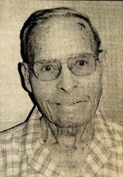

Merlan Stanley Miller
| Birth | : | 21 Aug 1902 Shields, Lane County, Kansas, USA |
| Death | : | 7 Dec 2000 Chelan, Chelan County, Washington, USA |
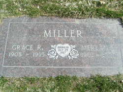
| Burial | : | Chelan Fraternal Cemetery, Chelan, Chelan County, USA |
| Coordinate | : | 47.8502998, -120.0081024 |
| Plot | : | South Fraternal Row18 STBLK18 LS3 |
| Inscription | : | Grace R Miller - married Oct. 29, 1927 |
| Description | : | Merlan Stanley Miller - posted Dec. 11, 2000 Chelan Merlan Stanley Miller, beloved by family and friends, passed away at the Lake Chelan Community Hospital on Thursday, Dec. 7, 2000 at the age of 98. He was born an identical twin Aug. 21, 1902 at Shields, KS. On Oct. 29, 1927, he was married to Grace R. Bowman at Dighton, KS. Following their marriage, they made their home in Kansas, Oklahoma, Colorado and New Mexico where Merlan worked on state road construction. In 1936, they moved to Whatcom County and then to Chelan in 1949. Merlan was a foreman at Valley Evaporating Co. in... Read More |
frequently asked questions (FAQ):
-
Where is Merlan Stanley Miller's memorial?
Merlan Stanley Miller's memorial is located at: Chelan Fraternal Cemetery, Chelan, Chelan County, USA.
-
When did Merlan Stanley Miller death?
Merlan Stanley Miller death on 7 Dec 2000 in Chelan, Chelan County, Washington, USA
-
Where are the coordinates of the Merlan Stanley Miller's memorial?
Latitude: 47.8502998
Longitude: -120.0081024
Family Members:
Parent
Spouse
Siblings
Children
Flowers:


Nearby Cemetories:
1. Chelan Fraternal Cemetery
Chelan, Chelan County, USA
Coordinate: 47.8502998, -120.0081024
2. Mount Olivet Cemetery
Chelan, Chelan County, USA
Coordinate: 47.8451000, -119.9946000
3. Saint Andrews Episcopal Church
Chelan, Chelan County, USA
Coordinate: 47.8397460, -120.0183780
4. Riverview Cemetery
Chelan, Chelan County, USA
Coordinate: 47.8335991, -119.9944000
5. Manson Indian Cemetery
Manson, Chelan County, USA
Coordinate: 47.8800000, -120.1300000
6. Ballard Family Cemetery
Stayman, Chelan County, USA
Coordinate: 47.7811100, -120.1133300
7. Fletcher Cemetery
Douglas County, USA
Coordinate: 47.7430992, -119.9403000
8. Brays Landing Cemetery
Douglas County, USA
Coordinate: 47.7364120, -120.1704660
9. Kummer Cemetery
Waterville, Douglas County, USA
Coordinate: 47.6559000, -120.0332000
10. Packwood Memorial Cemetery
Dyer, Douglas County, USA
Coordinate: 48.0118305, -119.8178880
11. Dick Family Cemetery
Okanogan County, USA
Coordinate: 48.0502700, -119.9241700
12. Miller Family Cemetery
Okanogan County, USA
Coordinate: 48.0530300, -119.9288000
13. Pateros Cemetery
Pateros, Okanogan County, USA
Coordinate: 48.0516600, -119.9097300
14. Waterville Cemetery
Waterville, Douglas County, USA
Coordinate: 47.6418500, -120.0685940
15. Gate of Heaven Catholic Cemetery
Waterville, Douglas County, USA
Coordinate: 47.6382100, -120.0671690
16. Douglas Lutheran Cemetery
Douglas County, USA
Coordinate: 47.6189003, -119.9614029
17. Badger Mountain View Cemetery
Douglas County, USA
Coordinate: 47.6088000, -120.0476000
18. Mansfield Cemetery
Mansfield, Douglas County, USA
Coordinate: 47.8088880, -119.6508330
19. Orondo Community Cemetery
Orondo, Douglas County, USA
Coordinate: 47.6486015, -120.2136002
20. Buckingham Cemetery
Douglas County, USA
Coordinate: 47.8669014, -119.6286011
21. Happy Home Cemetery
Farmer, Douglas County, USA
Coordinate: 47.6268997, -119.8125000
22. Methow Cemetery
Methow, Okanogan County, USA
Coordinate: 48.1102982, -120.0124969
23. Entiat Cemetery
Entiat, Chelan County, USA
Coordinate: 47.6755981, -120.3043976
24. Bridgeport Cemetery
Bridgeport, Douglas County, USA
Coordinate: 48.0050000, -119.6738800