
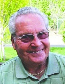


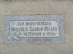
Veryle Edwin Miller
| Birth | : | 6 Apr 1930 Hays, Ellis County, Kansas, USA |
| Death | : | 31 Dec 2019 Chelan, Chelan County, Washington, USA |
| Burial | : | Chelan Fraternal Cemetery, Chelan, Chelan County, USA |
| Coordinate | : | 47.8502998, -120.0081024 |
| Plot | : | North Fraternal Row 46 STBLK45 L1A |
| Description | : | m: Gloria Dietrich 3 Mar 1951 in Kootenai Co, ID Veryle Miller, 89 years old, went to be with Jesus on December 31, 2019. Veryle was born in Hays, Kansas April 6, 1930. During his childhood his family moved frequently and eventually settled in Lake Chelan, WA. Veryle was drafted into the Army in March 1951 during the Korean War. He married Gloria Dietrich March 3 (68 years of marriage) just 2 days before leaving for boot camp. During the war he was stationed in Sendai, Japan. In 1953 Veryle received an honorable discharge and returned to Chelan to... Read More |
frequently asked questions (FAQ):
-
Where is Veryle Edwin Miller's memorial?
Veryle Edwin Miller's memorial is located at: Chelan Fraternal Cemetery, Chelan, Chelan County, USA.
-
When did Veryle Edwin Miller death?
Veryle Edwin Miller death on 31 Dec 2019 in Chelan, Chelan County, Washington, USA
-
Where are the coordinates of the Veryle Edwin Miller's memorial?
Latitude: 47.8502998
Longitude: -120.0081024
Family Members:
Parent
Spouse
Children
Flowers:


Nearby Cemetories:
1. Chelan Fraternal Cemetery
Chelan, Chelan County, USA
Coordinate: 47.8502998, -120.0081024
2. Mount Olivet Cemetery
Chelan, Chelan County, USA
Coordinate: 47.8451000, -119.9946000
3. Saint Andrews Episcopal Church
Chelan, Chelan County, USA
Coordinate: 47.8397460, -120.0183780
4. Riverview Cemetery
Chelan, Chelan County, USA
Coordinate: 47.8335991, -119.9944000
5. Manson Indian Cemetery
Manson, Chelan County, USA
Coordinate: 47.8800000, -120.1300000
6. Ballard Family Cemetery
Stayman, Chelan County, USA
Coordinate: 47.7811100, -120.1133300
7. Fletcher Cemetery
Douglas County, USA
Coordinate: 47.7430992, -119.9403000
8. Brays Landing Cemetery
Douglas County, USA
Coordinate: 47.7364120, -120.1704660
9. Kummer Cemetery
Waterville, Douglas County, USA
Coordinate: 47.6559000, -120.0332000
10. Packwood Memorial Cemetery
Dyer, Douglas County, USA
Coordinate: 48.0118305, -119.8178880
11. Dick Family Cemetery
Okanogan County, USA
Coordinate: 48.0502700, -119.9241700
12. Miller Family Cemetery
Okanogan County, USA
Coordinate: 48.0530300, -119.9288000
13. Pateros Cemetery
Pateros, Okanogan County, USA
Coordinate: 48.0516600, -119.9097300
14. Waterville Cemetery
Waterville, Douglas County, USA
Coordinate: 47.6418500, -120.0685940
15. Gate of Heaven Catholic Cemetery
Waterville, Douglas County, USA
Coordinate: 47.6382100, -120.0671690
16. Douglas Lutheran Cemetery
Douglas County, USA
Coordinate: 47.6189003, -119.9614029
17. Badger Mountain View Cemetery
Douglas County, USA
Coordinate: 47.6088000, -120.0476000
18. Mansfield Cemetery
Mansfield, Douglas County, USA
Coordinate: 47.8088880, -119.6508330
19. Orondo Community Cemetery
Orondo, Douglas County, USA
Coordinate: 47.6486015, -120.2136002
20. Buckingham Cemetery
Douglas County, USA
Coordinate: 47.8669014, -119.6286011
21. Happy Home Cemetery
Farmer, Douglas County, USA
Coordinate: 47.6268997, -119.8125000
22. Methow Cemetery
Methow, Okanogan County, USA
Coordinate: 48.1102982, -120.0124969
23. Entiat Cemetery
Entiat, Chelan County, USA
Coordinate: 47.6755981, -120.3043976
24. Bridgeport Cemetery
Bridgeport, Douglas County, USA
Coordinate: 48.0050000, -119.6738800