
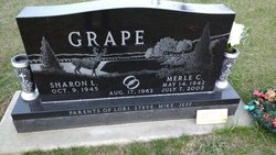
Merle Clair Grape
| Birth | : | 14 May 1941 Genoa, Nance County, Nebraska, USA |
| Death | : | 7 Jul 2003 Albion, Boone County, Nebraska, USA |
| Burial | : | Great Harwood Cemetery, Great Harwood, Hyndburn Borough, England |
| Coordinate | : | 53.7796190, -2.4091680 |
| Description | : | Thanks to contributor #48796369 Merle Clair Grape, 61, of rural Albion died Monday, July 7, 2003, at Boone County Health Center following an apparent heart attack while at work. Services will be at 10:30 a.m. Thursday at First Baptist Church in Albion. The Rev. Tim Stahl will officiate. Burial will be in the Rose Hill Cemetery at Albion. Visitation will be from 3-8 p.m. today at Levander Funeral Home in Albion. Mr. Grape was born May 14, 1941, at Genoa to Clarence "Bud" and Marjorie (Condreay) Grape. Survivors of his immediate family include his wife,... Read More |
frequently asked questions (FAQ):
-
Where is Merle Clair Grape's memorial?
Merle Clair Grape's memorial is located at: Great Harwood Cemetery, Great Harwood, Hyndburn Borough, England.
-
When did Merle Clair Grape death?
Merle Clair Grape death on 7 Jul 2003 in Albion, Boone County, Nebraska, USA
-
Where are the coordinates of the Merle Clair Grape's memorial?
Latitude: 53.7796190
Longitude: -2.4091680
Family Members:
Parent

Siblings
Flowers:


Nearby Cemetories:
1. Great Harwood Cemetery
Great Harwood, Hyndburn Borough, England
Coordinate: 53.7796190, -2.4091680
2. Our Lady and Saint Hubert
Great Harwood, Hyndburn Borough, England
Coordinate: 53.7851070, -2.4009760
3. St. Bartholomew's Churchyard
Great Harwood, Hyndburn Borough, England
Coordinate: 53.7900670, -2.4055460
4. All Saints Churchyard
Clayton-le-Moors, Hyndburn Borough, England
Coordinate: 53.7738520, -2.3881690
5. Barnes Square Weslyan Methodist Churchyard
Clayton-le-Moors, Hyndburn Borough, England
Coordinate: 53.7744350, -2.3853800
6. St Marys Burial Ground
Clayton-le-Moors, Hyndburn Borough, England
Coordinate: 53.7792778, -2.3705871
7. Church and Clayton-le-Moors Cemetery
Accrington, Hyndburn Borough, England
Coordinate: 53.7630200, -2.3804820
8. St James Churchyard
Church, Hyndburn Borough, England
Coordinate: 53.7574640, -2.3942660
9. St. James' Parish Church
Accrington, Hyndburn Borough, England
Coordinate: 53.7519900, -2.3652600
10. Accrington Cemetery and Crematorium
Accrington, Hyndburn Borough, England
Coordinate: 53.7623787, -2.3508649
11. St James Church
Altham, Hyndburn Borough, England
Coordinate: 53.7928940, -2.3465250
12. Blackburn Cemetery
Blackburn, Blackburn with Darwen Unitary Authority, England
Coordinate: 53.7662430, -2.4726050
13. Saint Mary and All Saints Churchyard
Whalley, Ribble Valley Borough, England
Coordinate: 53.8211890, -2.4078080
14. New Lane Baptist Chapel Chapelyard
Oswaldwistle, Hyndburn Borough, England
Coordinate: 53.7381100, -2.4049500
15. St. John's Churchyard
Read, Ribble Valley Borough, England
Coordinate: 53.8088800, -2.3585600
16. Christ Church Churchyard
Accrington, Hyndburn Borough, England
Coordinate: 53.7478560, -2.3605820
17. Immanuel Churchyard
Oswaldwistle, Hyndburn Borough, England
Coordinate: 53.7358300, -2.4056200
18. St Peter Churchyard
Salesbury, Ribble Valley Borough, England
Coordinate: 53.7915000, -2.4859100
19. St. Leonard Old Churchyard
Langho, Ribble Valley Borough, England
Coordinate: 53.8178590, -2.4552870
20. St Alban's Churchyard
Blackburn, Blackburn with Darwen Unitary Authority, England
Coordinate: 53.7530090, -2.4748540
21. Brockhall Hospital Cemetery
Brockhall Village, Ribble Valley Borough, England
Coordinate: 53.8186850, -2.4560220
22. Holy Trinity Church
Blackburn with Darwen Unitary Authority, England
Coordinate: 53.7511727, -2.4747178
23. Whalley, Wiswell and Barrow Cemetery
Whalley, Ribble Valley Borough, England
Coordinate: 53.8308490, -2.4057280
24. Mount St Presbyterian Chapelyard
Blackburn, Blackburn with Darwen Unitary Authority, England
Coordinate: 53.7478000, -2.4775000