
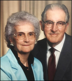
Michael Bernard “Mike and MB” Naughtin
| Birth | : | 18 Dec 1918 Spalding, Greeley County, Nebraska, USA |
| Death | : | 5 Jul 2006 Spalding, Greeley County, Nebraska, USA |
| Burial | : | Elder Creek Cemetery, Florin, Sacramento County, USA |
| Coordinate | : | 38.5111008, -121.4169006 |
| Description | : | Son of Arthur T. & Margaret (Murphy) Naughtin. Married to Rita Dunning on 8-19-1950 at St. Michael's Catholic Church at Spalding, NE. WW II Veteran - US Army - June 1941/Oct. 1945. He attended Omaha Barber School and served his apprenticeship in various shops in Nebraska. He owned and operated Mike's Barber Shop for more than 57 years. He was a member of the Spalding Fire Department, and the Spalding Town Board. He served on the Spalding Academy and Spalding Public School Boards. |
frequently asked questions (FAQ):
-
Where is Michael Bernard “Mike and MB” Naughtin's memorial?
Michael Bernard “Mike and MB” Naughtin's memorial is located at: Elder Creek Cemetery, Florin, Sacramento County, USA.
-
When did Michael Bernard “Mike and MB” Naughtin death?
Michael Bernard “Mike and MB” Naughtin death on 5 Jul 2006 in Spalding, Greeley County, Nebraska, USA
-
Where are the coordinates of the Michael Bernard “Mike and MB” Naughtin's memorial?
Latitude: 38.5111008
Longitude: -121.4169006
Family Members:
Parent

Spouse
Siblings
Flowers:


Nearby Cemetories:
1. Elder Creek Cemetery
Florin, Sacramento County, USA
Coordinate: 38.5111008, -121.4169006
2. Tinh Xa Ngoc An Temple Columbarium
Sacramento, Sacramento County, USA
Coordinate: 38.5190200, -121.4159500
3. Sacramento County Veterans Memorial Cemetery
Sacramento, Sacramento County, USA
Coordinate: 38.5252838, -121.4239120
4. Sacramento County Cemetery
Sacramento County, USA
Coordinate: 38.5267900, -121.4233700
5. Russian Orthodox Cemetery
Sacramento, Sacramento County, USA
Coordinate: 38.5268800, -121.4244300
6. Sacramento Memorial Lawn Cemetery
Sacramento, Sacramento County, USA
Coordinate: 38.5146484, -121.4380341
7. Home of Peace Cemetery
Sacramento, Sacramento County, USA
Coordinate: 38.5137558, -121.4382782
8. Sacramento County Hospital Cemetery
Sacramento, Sacramento County, USA
Coordinate: 38.5289300, -121.4239100
9. Saint Mary's Catholic Cemetery and Mausoleum
Sacramento, Sacramento County, USA
Coordinate: 38.5298900, -121.4261200
10. Saint Rose Cemetery (Defunct)
Sacramento, Sacramento County, USA
Coordinate: 38.5208015, -121.4672012
11. Pho Minh Temple Columbarium
Sacramento, Sacramento County, USA
Coordinate: 38.5340100, -121.4769000
12. East Lawn Memorial Park
Sacramento, Sacramento County, USA
Coordinate: 38.5612960, -121.4492760
13. Sacramento Pet Cemetery
Sacramento, Sacramento County, USA
Coordinate: 38.4815870, -121.3402080
14. Saint Joseph Cemetery
Sacramento, Sacramento County, USA
Coordinate: 38.5574989, -121.4835968
15. Bellview Cemetery
Sacramento, Sacramento County, USA
Coordinate: 38.5153580, -121.3257446
16. New Helvetia Cemetery (Defunct)
Sacramento, Sacramento County, USA
Coordinate: 38.5731600, -121.4639900
17. Quiet Haven Memorial Park Cemetery
Sacramento, Sacramento County, USA
Coordinate: 38.5109711, -121.3245621
18. San Joaquin Cemetery
Sacramento, Sacramento County, USA
Coordinate: 38.4387665, -121.4034653
19. Trinity Episcopal Cathedral Columbarium
Sacramento, Sacramento County, USA
Coordinate: 38.5705500, -121.4723770
20. Odd Fellows Lawn Cemetery and Mausoleum
Sacramento, Sacramento County, USA
Coordinate: 38.5585000, -121.5011000
21. Buddhist Church of Sacramento Nokotsudo
Sacramento, Sacramento County, USA
Coordinate: 38.5639300, -121.4978400
22. Masonic Lawn Cemetery
Sacramento, Sacramento County, USA
Coordinate: 38.5604720, -121.5032600
23. Sunset Hill Cemetery
Sacramento, Sacramento County, USA
Coordinate: 38.5608000, -121.5037300
24. Sacramento City Cemetery
Sacramento, Sacramento County, USA
Coordinate: 38.5636864, -121.5009537