
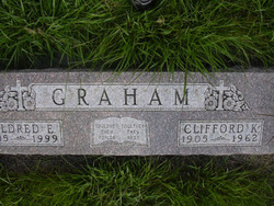

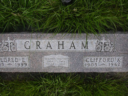
Mildred Edna Roberts Graham
| Birth | : | 15 Dec 1905 Adams County, Nebraska, USA |
| Death | : | 3 Jul 1999 Kenesaw, Adams County, Nebraska, USA |
| Burial | : | Tower Hill Memorial, London Borough of Tower Hamlets, England |
| Coordinate | : | 51.5096016, -0.0777000 |
| Plot | : | Block 4, Lot 24, North 1/2 |
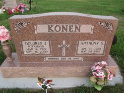
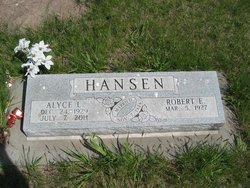
| Description | : | Mildred Graham graduated from Kenesaw High School and attended Kearney State Teacher's College in Kearney for one year. She then taught at a country school in rural Adams County for a year. On March 5, 1925 she married Clifford K. Graham. She was a member of Kenesaw Methodist Church and was a past member of Adams County Extension Club and Adams County Women's Choir. Survivors were four daughters, Dolores Konen, Alyce Hansen and Shirley Gronewold all of Hastings, and Naomi Hesselgesser of Tacoma, Washington; five sons, Bernard of Lakewood, CI, Gerald of Aurora, CO, C. Keith of Juniata and Larry... Read More |
frequently asked questions (FAQ):
-
Where is Mildred Edna Roberts Graham's memorial?
Mildred Edna Roberts Graham's memorial is located at: Tower Hill Memorial, London Borough of Tower Hamlets, England.
-
When did Mildred Edna Roberts Graham death?
Mildred Edna Roberts Graham death on 3 Jul 1999 in Kenesaw, Adams County, Nebraska, USA
-
Where are the coordinates of the Mildred Edna Roberts Graham's memorial?
Latitude: 51.5096016
Longitude: -0.0777000
Family Members:
Parent
Spouse
Siblings
Children


Nearby Cemetories:
1. Tower Hill Memorial
London Borough of Tower Hamlets, England
Coordinate: 51.5096016, -0.0777000
2. All Hallows by the Tower Churchyard
London, City of London, England
Coordinate: 51.5093600, -0.0794020
3. Chapel of Saint Peter-ad-Vincula
London Borough of Tower Hamlets, England
Coordinate: 51.5085335, -0.0769200
4. Church of the Crutched Friars
London, City of London, England
Coordinate: 51.5108000, -0.0785000
5. St Olave Hart Street Churchyard
London, City of London, England
Coordinate: 51.5108930, -0.0795990
6. All Hallows Staining Tower
London, City of London, England
Coordinate: 51.5115776, -0.0804890
7. Holy Trinity Minories Churchyard
Aldgate, City of London, England
Coordinate: 51.5115140, -0.0745780
8. St. Dunstan-in-the-East Churchyard
London, City of London, England
Coordinate: 51.5096540, -0.0824830
9. Abbey of St Mary Graces
London Borough of Tower Hamlets, England
Coordinate: 51.5094000, -0.0723000
10. Abbey of the Minoresses of St. Clare without Aldgate Churchyard
Aldgate, City of London, England
Coordinate: 51.5125370, -0.0749860
11. St. James Duke's Place Churchyard
Aldgate, City of London, England
Coordinate: 51.5128970, -0.0790280
12. St. Mary-at-Hill Churchyard
Billingsgate, City of London, England
Coordinate: 51.5101050, -0.0836680
13. St Katherine Cree Churchyard
London, City of London, England
Coordinate: 51.5134315, -0.0791360
14. St. Katharine’s by the Tower Churchyard
London Borough of Tower Hamlets, England
Coordinate: 51.5071550, -0.0725960
15. Priory of Holy Trinity
Aldgate, City of London, England
Coordinate: 51.5138190, -0.0780890
16. St Botolph Billingsgate Churchyard (Defunct)
London, City of London, England
Coordinate: 51.5096860, -0.0847310
17. St. George's Botolph Lane
Billingsgate, City of London, England
Coordinate: 51.5101840, -0.0847730
18. St Botolph without Aldgate Churchyard
Aldgate, City of London, England
Coordinate: 51.5140120, -0.0763420
19. St. Benet's Churchyard
Bridge, City of London, England
Coordinate: 51.5115240, -0.0846030
20. St. Leonard's Churchyard
Bridge, City of London, England
Coordinate: 51.5105870, -0.0855570
21. Great Fire of London Monument
London, City of London, England
Coordinate: 51.5101100, -0.0859990
22. St Mary Magdalene (Defunct)
London, City of London, England
Coordinate: 51.5100480, -0.0862540
23. St. Magnus the Martyr Churchyard
London, City of London, England
Coordinate: 51.5092500, -0.0862880
24. All Hallows Lombard Street
London, City of London, England
Coordinate: 51.5123000, -0.0854000