
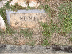
Minnie Jones
| Birth | : | 1896 |
| Death | : | 1951 |
| Burial | : | All Saints Churchyard, Barlby, Selby District, England |
| Coordinate | : | 53.7987840, -1.0415840 |
frequently asked questions (FAQ):
-
Where is Minnie Jones's memorial?
Minnie Jones's memorial is located at: All Saints Churchyard, Barlby, Selby District, England.
-
When did Minnie Jones death?
Minnie Jones death on 1951 in
-
Where are the coordinates of the Minnie Jones's memorial?
Latitude: 53.7987840
Longitude: -1.0415840
Family Members:
Parent


Siblings


Flowers:


Nearby Cemetories:
1. All Saints Churchyard
Barlby, Selby District, England
Coordinate: 53.7987840, -1.0415840
2. Selby Abbey
Selby, Selby District, England
Coordinate: 53.7840990, -1.0670270
3. Selby Cemetery
Selby, Selby District, England
Coordinate: 53.7766610, -1.0775960
4. St. Mary's Churchyard
Riccall, Selby District, England
Coordinate: 53.8330620, -1.0601630
5. St. Wilfrid's Parish Churchyard
Brayton, Selby District, England
Coordinate: 53.7718060, -1.0849010
6. All Saints Churchyard
Wistow, Selby District, England
Coordinate: 53.8134750, -1.1014755
7. St. Helen's Churchyard
Skipwith, Selby District, England
Coordinate: 53.8386300, -1.0022900
8. St Mary the Virgin Churchyard
Hemingbrough, Selby District, England
Coordinate: 53.7672100, -0.9796300
9. All Saints Churchyard
Cawood, Selby District, England
Coordinate: 53.8331970, -1.1235660
10. Rythergate Cemetery
Cawood, Selby District, England
Coordinate: 53.8356000, -1.1347700
11. St Helen Churchyard
Stillingfleet, Selby District, England
Coordinate: 53.8618710, -1.0994760
12. St. Helen's Churchyard
Barmby on the Marsh, East Riding of Yorkshire Unitary Authority, England
Coordinate: 53.7476490, -0.9549090
13. All Saints Churchyard
Bubwith, East Riding of Yorkshire Unitary Authority, England
Coordinate: 53.8170680, -0.9200130
14. All Saints Churchyard
Aughton, East Riding of Yorkshire Unitary Authority, England
Coordinate: 53.8393490, -0.9352200
15. Hambleton Cemetery
Hambleton, Selby District, England
Coordinate: 53.7715910, -1.1624600
16. St Mary Churchyard
Hambleton, Selby District, England
Coordinate: 53.7715910, -1.1624600
17. Drax Cemetery
Drax, Selby District, England
Coordinate: 53.7272540, -0.9875330
18. Barmby on the Marsh Parish Burial Ground
Barmby on the Marsh, East Riding of Yorkshire Unitary Authority, England
Coordinate: 53.7472990, -0.9401910
19. St Peter and St Paul Churchyard
Drax, Selby District, England
Coordinate: 53.7293790, -0.9771560
20. Friends Burial Ground
Drax, Selby District, England
Coordinate: 53.7291640, -0.9771490
21. St John Churchyard
Acaster Selby, Selby District, England
Coordinate: 53.8614750, -1.1283740
22. St Mary and St Lawrence Churchyard
Ellerton, East Riding of Yorkshire Unitary Authority, England
Coordinate: 53.8499000, -0.9347520
23. St. Helen's Churchyard
Escrick, Selby District, England
Coordinate: 53.8805200, -1.0460990
24. St John The Baptist Churchyard
Chapel Haddlesey, Selby District, England
Coordinate: 53.7279200, -1.1185700