
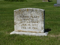
Minnie Pearl Mansur Gorham
| Birth | : | 15 Jan 1892 Ray County, Missouri, USA |
| Death | : | 14 Feb 1916 Ray County, Missouri, USA |
| Burial | : | Hastings Cemetery, Hastings, Mills County, USA |
| Coordinate | : | 41.0097008, -95.4993973 |
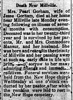
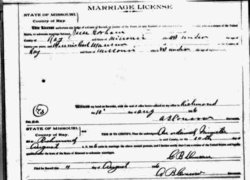
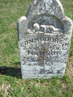
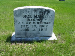
| Description | : | 1900 United States Federal Census Minnie Mansur Age: 8 Birth Date: Jan 1892 Birthplace: Missouri Home in 1900: Grape Grove, Ray, Missouri Race: White Gender: Female Relation to Head of House: Daughter (Child) Marital Status: Single Father's name: Comodore Mansur Father's Birthplace: Missouri Mother's Birthplace: Missouri Household Members: Comodore Mansur, age 39 Minnie Mansur, age 8 Leona Mansur, age 6 Goldy M Mansur, age 4 James P Mansur, age 2 Margaret Mansur, age 27 (Sister) ~~~~~~~~~~~~~~ Jesse Gorham age 19 married Minnie Pearl Mausar (Mansur) age 15 on August 10, 1906 in Richmond, Ray County, Missouri. 1910 United States Census Head of House: Jesse F... Read More |
frequently asked questions (FAQ):
-
Where is Minnie Pearl Mansur Gorham's memorial?
Minnie Pearl Mansur Gorham's memorial is located at: Hastings Cemetery, Hastings, Mills County, USA.
-
When did Minnie Pearl Mansur Gorham death?
Minnie Pearl Mansur Gorham death on 14 Feb 1916 in Ray County, Missouri, USA
-
Where are the coordinates of the Minnie Pearl Mansur Gorham's memorial?
Latitude: 41.0097008
Longitude: -95.4993973
Family Members:
Parent
Spouse
Siblings
Children
Flowers:


Nearby Cemetories:
1. Hastings Cemetery
Hastings, Mills County, USA
Coordinate: 41.0097008, -95.4993973
2. North Grove Cemetery
Hastings, Mills County, USA
Coordinate: 41.0161018, -95.4618988
3. South Grove Cemetery
Mills County, USA
Coordinate: 40.9775009, -95.4931030
4. Wearin Cemetery
Malvern, Mills County, USA
Coordinate: 41.0395000, -95.5313000
5. Parker Cemetery
White Cloud, Mills County, USA
Coordinate: 40.9737649, -95.5184363
6. Malvern Cemetery
Malvern, Mills County, USA
Coordinate: 40.9886017, -95.5785980
7. Cotten Cemetery
Mills County, USA
Coordinate: 41.0845000, -95.5167000
8. Emerson Cemetery
Emerson, Mills County, USA
Coordinate: 41.0325012, -95.4021988
9. East Liberty Cemetery
Malvern, Mills County, USA
Coordinate: 41.0592346, -95.6005020
10. Wesley Chapel Cemetery
Henderson, Mills County, USA
Coordinate: 41.1019249, -95.4987793
11. Saylers Farm Cemetery
Henderson, Mills County, USA
Coordinate: 41.1083300, -95.4919440
12. Lowens Cemetery
Garfield Township, Montgomery County, USA
Coordinate: 41.0527728, -95.3758292
13. Hillsdale Cemetery
Glenwood, Mills County, USA
Coordinate: 41.0097008, -95.6427994
14. Walnut Cemetery
Montgomery County, USA
Coordinate: 40.9519005, -95.3741989
15. David Farm Cemetery
West Township, Montgomery County, USA
Coordinate: 40.9249960, -95.3766593
16. Riverside Cemetery
Randolph, Fremont County, USA
Coordinate: 40.8806000, -95.5269012
17. Monroe Cemetery
Imogene, Fremont County, USA
Coordinate: 40.8880997, -95.4222031
18. Farm Creek Cemetery
Henderson, Mills County, USA
Coordinate: 41.1319008, -95.4186020
19. Mills County Farm Cemetery
Glenwood, Mills County, USA
Coordinate: 41.0417930, -95.6756530
20. Silver City Cemetery
Silver City, Mills County, USA
Coordinate: 41.1042442, -95.6380005
21. Randolph Cemetery
Randolph, Fremont County, USA
Coordinate: 40.8769493, -95.5695038
22. Fairview Cemetery
Tabor, Mills County, USA
Coordinate: 40.9453011, -95.6716995
23. Salem Cemetery
Red Oak, Montgomery County, USA
Coordinate: 40.9733009, -95.3088989
24. Bomar Family Cemetery
Mills County, USA
Coordinate: 41.0369400, -95.6941700