
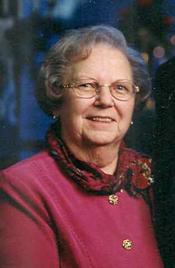

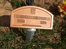
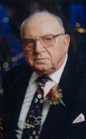
Mrs Edna E. Stetler Hundley
| Birth | : | 20 Apr 1925 Oak Hill, Clay County, Kansas, USA |
| Death | : | 31 Aug 2013 Clay Center, Clay County, Kansas, USA |
| Burial | : | Rose Meron Cemetery, Oak Hill, Clay County, USA |
| Coordinate | : | 39.2194700, -97.3338900 |
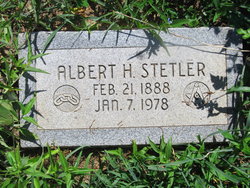
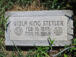
| Description | : | EDNA E. HUNDLEY died August 31, 2013 at Presbyterian Manor, Clay Center, KS at the age of 88. She was born on April 20, 1925 in Oak Hill, Kansas the daughter of Albert and Viola (King) Stetler. Edna was raised in the Oak Hill, KS area and graduated from Longford High School. She married Harold Hundley on August 17, 1947 and he survives of the home. She was a Registered Nurse and was the Director of Nusrsing for the North East Health Center in Wichita, KS. She later worked for the Clay Center Presbyterian Manor in Clay Center, KS and retired... Read More |
frequently asked questions (FAQ):
-
Where is Mrs Edna E. Stetler Hundley's memorial?
Mrs Edna E. Stetler Hundley's memorial is located at: Rose Meron Cemetery, Oak Hill, Clay County, USA.
-
When did Mrs Edna E. Stetler Hundley death?
Mrs Edna E. Stetler Hundley death on 31 Aug 2013 in Clay Center, Clay County, Kansas, USA
-
Where are the coordinates of the Mrs Edna E. Stetler Hundley's memorial?
Latitude: 39.2194700
Longitude: -97.3338900
Family Members:
Parent
Spouse
Siblings
Flowers:


Nearby Cemetories:
1. Rose Meron Cemetery
Oak Hill, Clay County, USA
Coordinate: 39.2194700, -97.3338900
2. Pleasant Valley Cemetery
Oak Hill, Clay County, USA
Coordinate: 39.2468987, -97.2889023
3. Wesleyan Cemetery
Oak Hill, Clay County, USA
Coordinate: 39.2268982, -97.2572021
4. Mount Liberty Church Cemetery
Ottawa County, USA
Coordinate: 39.2489400, -97.4356200
5. Swartwood Cemetery
Longford, Clay County, USA
Coordinate: 39.1323200, -97.3431500
6. Shields Cemetery
Clay County, USA
Coordinate: 39.3208008, -97.3507996
7. Table Mound Cemetery
Idana, Clay County, USA
Coordinate: 39.3141300, -97.2792300
8. Keystone Cemetery
Manchester, Dickinson County, USA
Coordinate: 39.1185989, -97.2917023
9. Hebron Cemetery
Clay County, USA
Coordinate: 39.3213800, -97.2601400
10. Vine Creek Cemetery
Ottawa County, USA
Coordinate: 39.1194000, -97.4180984
11. Athelstane Cemetery
Athelstane Township, Clay County, USA
Coordinate: 39.1768990, -97.1753006
12. Pleasant Ridge Cemetery
Clay County, USA
Coordinate: 39.2789001, -97.1841965
13. Miltonvale Cemetery
Miltonvale, Cloud County, USA
Coordinate: 39.3358002, -97.4447021
14. White Cloud Cemetery
Manchester, Dickinson County, USA
Coordinate: 39.0744019, -97.3525009
15. Idana Cemetery
Idana, Clay County, USA
Coordinate: 39.3574500, -97.2693300
16. Zion Lutheran Cemetery
Clay County, USA
Coordinate: 39.2928009, -97.1557999
17. Mizpah Cemetery
Clay County, USA
Coordinate: 39.2057800, -97.1238500
18. Smith Grave
Miltonvale, Cloud County, USA
Coordinate: 39.3645300, -97.4308700
19. Fairview Cemetery
Lamar, Ottawa County, USA
Coordinate: 39.2928009, -97.5299988
20. Ackley Cemetery
Ottawa County, USA
Coordinate: 39.0893160, -97.4797040
21. Greenridge Cemetery
Dickinson County, USA
Coordinate: 39.1199989, -97.1433029
22. Henry Cemetery
Buckeye, Dickinson County, USA
Coordinate: 39.0828018, -97.1857986
23. Prairiedale Cemetery
Talmage, Dickinson County, USA
Coordinate: 39.0471992, -97.2652969
24. Republican City Cemetery
Clay Center, Clay County, USA
Coordinate: 39.3431015, -97.1628036