
| Birth | : | 2 May 1904 Davenport, Thayer County, Nebraska, USA |
| Death | : | 30 Oct 1994 Edgar, Clay County, Nebraska, USA |
| Burial | : | Fairfield Cemetery, Fairfield, Clay County, USA |
| Coordinate | : | 40.4094009, -98.0982971 |
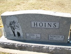
| Description | : | Myrtle Aileen Hoins, 90, Edgar, died Sunday at Community Care of Edgar. Services were Wednesday at Community Presbyterian Church, Fairfield, with the Rev. Denzel Nonhof officiating. Burial was in Fairfield Cemetery. Hoins, daughter of Emiel and Edith Avers, was born in Davenport. She attended rural school and graduated from Edgar High School. She attended Peru Normal College, and taught school near Edgar and for two years at Mt. Clare. She was united in marriage to Frank Hoins, June 14,1923. They farmed near Nelson, later moving to a farm near Taylor. In l948 they moved... Read More |
frequently asked questions (FAQ):
-
Where is Myrtle Aileen Avers Hoins's memorial?
Myrtle Aileen Avers Hoins's memorial is located at: Fairfield Cemetery, Fairfield, Clay County, USA.
-
When did Myrtle Aileen Avers Hoins death?
Myrtle Aileen Avers Hoins death on 30 Oct 1994 in Edgar, Clay County, Nebraska, USA
-
Where are the coordinates of the Myrtle Aileen Avers Hoins's memorial?
Latitude: 40.4094009
Longitude: -98.0982971
Family Members:
Parent

Spouse
Siblings

Children
Flowers:


Nearby Cemetories:
1. Fairfield Cemetery
Fairfield, Clay County, USA
Coordinate: 40.4094009, -98.0982971
2. Saint Aloysius Cemetery
Deweese, Clay County, USA
Coordinate: 40.3932991, -98.1278000
3. Assumption Church Cemetery
Deweese, Clay County, USA
Coordinate: 40.3507000, -98.1324000
4. Saint Martin-Loucky Cemetery
Deweese, Clay County, USA
Coordinate: 40.3652496, -98.1948624
5. Hannum Graves
Lawrence, Nuckolls County, USA
Coordinate: 40.3456500, -98.1766800
6. Anandale Cemetery
Glenvil, Clay County, USA
Coordinate: 40.4661900, -98.1935300
7. Union Cemetery
Nuckolls County, USA
Coordinate: 40.3146706, -98.1236877
8. Smith Cemetery
Nelson, Nuckolls County, USA
Coordinate: 40.3078003, -98.0567017
9. Eller Cemetery
Clay Center, Clay County, USA
Coordinate: 40.4956700, -98.0145700
10. Liberty Creek Cemetery
Nuckolls County, USA
Coordinate: 40.3361015, -98.2035980
11. Edgar Cemetery
Edgar, Clay County, USA
Coordinate: 40.3587200, -97.9700200
12. Spring Ranch Cemetery
Clay County, USA
Coordinate: 40.4065100, -98.2484100
13. Clay Center Cemetery
Clay Center, Clay County, USA
Coordinate: 40.5325012, -98.0500031
14. Marshall Union Evergreen Cemetery
Clay Center, Clay County, USA
Coordinate: 40.4880300, -97.9573000
15. Zion Cemetery
Clay County, USA
Coordinate: 40.5382996, -98.1643982
16. Prairieview Cemetery
Ong, Clay County, USA
Coordinate: 40.4235100, -97.9093400
17. Glenville Union Cemetery
Glenvil, Clay County, USA
Coordinate: 40.5308980, -98.2052220
18. Sacred Heart Cemetery
Lawrence, Nuckolls County, USA
Coordinate: 40.2921982, -98.2268982
19. Glenvil Cemetery
Glenvil, Clay County, USA
Coordinate: 40.5088400, -98.2604700
20. Oxbow Cemetery
Nelson, Nuckolls County, USA
Coordinate: 40.2560997, -98.0280991
21. Chapel Grove Cemetery
Clay County, USA
Coordinate: 40.4660988, -97.8816986
22. Saint Pauls Lutheran Cemetery
Adams County, USA
Coordinate: 40.5104530, -98.2872960
23. Phil R Landon Gravesite
Angus, Nuckolls County, USA
Coordinate: 40.2703200, -97.9553200
24. Evergreen Cemetery
Lawrence, Nuckolls County, USA
Coordinate: 40.2922401, -98.2723236