
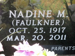

Nadine M Faulkner McKale
| Birth | : | 25 Oct 1917 Clay County, Kansas, USA |
| Death | : | 20 Mar 2011 Clay Center, Clay County, Kansas, USA |
| Burial | : | Rose Meron Cemetery, Oak Hill, Clay County, USA |
| Coordinate | : | 39.2194700, -97.3338900 |
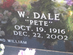
| Description | : | NADINE MCKALE died March 20, 2011 at Clay County Medical Center, Clay Center, KS at the age of 93. She was born on October 25, 1917 in Clay County Kansas, the daughter of John Faulkner and Margaret Lilley. Nadine graduated from Longford High School in 1935. She took Normal Training and taught at Black Hill country school in Clay County for 2 years. Nadine married Dale Pete McKale on April 27, 1938. In 1967 she began working at the Longford Post Office as a clerk. She became Postmaster of the Longford Post Office in 1973 and retired in 1987. Nadine... Read More |
frequently asked questions (FAQ):
-
Where is Nadine M Faulkner McKale's memorial?
Nadine M Faulkner McKale's memorial is located at: Rose Meron Cemetery, Oak Hill, Clay County, USA.
-
When did Nadine M Faulkner McKale death?
Nadine M Faulkner McKale death on 20 Mar 2011 in Clay Center, Clay County, Kansas, USA
-
Where are the coordinates of the Nadine M Faulkner McKale's memorial?
Latitude: 39.2194700
Longitude: -97.3338900
Family Members:
Parent

Spouse
Children

Flowers:


Nearby Cemetories:
1. Rose Meron Cemetery
Oak Hill, Clay County, USA
Coordinate: 39.2194700, -97.3338900
2. Pleasant Valley Cemetery
Oak Hill, Clay County, USA
Coordinate: 39.2468987, -97.2889023
3. Wesleyan Cemetery
Oak Hill, Clay County, USA
Coordinate: 39.2268982, -97.2572021
4. Mount Liberty Church Cemetery
Ottawa County, USA
Coordinate: 39.2489400, -97.4356200
5. Swartwood Cemetery
Longford, Clay County, USA
Coordinate: 39.1323200, -97.3431500
6. Shields Cemetery
Clay County, USA
Coordinate: 39.3208008, -97.3507996
7. Table Mound Cemetery
Idana, Clay County, USA
Coordinate: 39.3141300, -97.2792300
8. Keystone Cemetery
Manchester, Dickinson County, USA
Coordinate: 39.1185989, -97.2917023
9. Hebron Cemetery
Clay County, USA
Coordinate: 39.3213800, -97.2601400
10. Vine Creek Cemetery
Ottawa County, USA
Coordinate: 39.1194000, -97.4180984
11. Athelstane Cemetery
Athelstane Township, Clay County, USA
Coordinate: 39.1768990, -97.1753006
12. Pleasant Ridge Cemetery
Clay County, USA
Coordinate: 39.2789001, -97.1841965
13. Miltonvale Cemetery
Miltonvale, Cloud County, USA
Coordinate: 39.3358002, -97.4447021
14. White Cloud Cemetery
Manchester, Dickinson County, USA
Coordinate: 39.0744019, -97.3525009
15. Idana Cemetery
Idana, Clay County, USA
Coordinate: 39.3574500, -97.2693300
16. Zion Lutheran Cemetery
Clay County, USA
Coordinate: 39.2928009, -97.1557999
17. Mizpah Cemetery
Clay County, USA
Coordinate: 39.2057800, -97.1238500
18. Smith Grave
Miltonvale, Cloud County, USA
Coordinate: 39.3645300, -97.4308700
19. Fairview Cemetery
Lamar, Ottawa County, USA
Coordinate: 39.2928009, -97.5299988
20. Ackley Cemetery
Ottawa County, USA
Coordinate: 39.0893160, -97.4797040
21. Greenridge Cemetery
Dickinson County, USA
Coordinate: 39.1199989, -97.1433029
22. Henry Cemetery
Buckeye, Dickinson County, USA
Coordinate: 39.0828018, -97.1857986
23. Prairiedale Cemetery
Talmage, Dickinson County, USA
Coordinate: 39.0471992, -97.2652969
24. Republican City Cemetery
Clay Center, Clay County, USA
Coordinate: 39.3431015, -97.1628036