
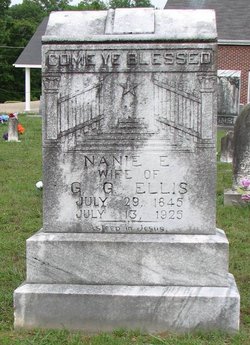
Nancy A. “Nanie” Garrett Ellis
| Birth | : | 29 Jul 1845 Decatur County, Tennessee, USA |
| Death | : | 13 Jul 1925 Decatur County, Tennessee, USA |
| Burial | : | Camp Ground Cemetery, Decaturville, Decatur County, USA |
| Coordinate | : | 35.5955700, -88.1625440 |
| Description | : | Nancy Garrett married Rev. Thomas C. Bell on September 27, 1877 at age 32. The couple had no children. (Confirmed on 1910 US Census) Thomas died in December 1899. Nancy was the Executrix of her husband's estate and remained in Henderson County for a time. She is found on the 1900 US Census as a Boarder with another family in the county. On November 15, 1901, Nancy married Green G. Ellis, a widower from Decatur County, Tennessee. The 1910 US Census shows the couple living in Henderson County. Green died in 1910. It appears that Nancy moved... Read More |
frequently asked questions (FAQ):
-
Where is Nancy A. “Nanie” Garrett Ellis's memorial?
Nancy A. “Nanie” Garrett Ellis's memorial is located at: Camp Ground Cemetery, Decaturville, Decatur County, USA.
-
When did Nancy A. “Nanie” Garrett Ellis death?
Nancy A. “Nanie” Garrett Ellis death on 13 Jul 1925 in Decatur County, Tennessee, USA
-
Where are the coordinates of the Nancy A. “Nanie” Garrett Ellis's memorial?
Latitude: 35.5955700
Longitude: -88.1625440
Family Members:
Parent
Spouse
Siblings

Flowers:


Nearby Cemetories:
1. Camp Ground Cemetery
Decaturville, Decatur County, USA
Coordinate: 35.5955700, -88.1625440
2. New Hope Baptist Church Cemetery
Decaturville, Decatur County, USA
Coordinate: 35.5992640, -88.1768180
3. Yarbro Cemetery
Decaturville, Decatur County, USA
Coordinate: 35.5807900, -88.1483890
4. Lowery Cemetery
Decaturville, Decatur County, USA
Coordinate: 35.5860480, -88.1314090
5. Houston - Young Cemetery
Decaturville, Decatur County, USA
Coordinate: 35.5851070, -88.1311530
6. Harrington Cemetery
Decaturville, Decatur County, USA
Coordinate: 35.5706580, -88.1788700
7. Myracle Family Cemetery
Parsons, Decatur County, USA
Coordinate: 35.6234610, -88.1776630
8. Freedman Chapel Cemetery
Decaturville, Decatur County, USA
Coordinate: 35.5789630, -88.1288390
9. Rosson Cemetery
Parsons, Decatur County, USA
Coordinate: 35.6243920, -88.1377210
10. Decaturville City Cemetery
Decaturville, Decatur County, USA
Coordinate: 35.5875240, -88.1200490
11. Graves Cemetery
Parsons, Decatur County, USA
Coordinate: 35.6274740, -88.1421470
12. Rushing Grove Church Cemetery
Decaturville, Decatur County, USA
Coordinate: 35.5673300, -88.1909020
13. Herndon Cemetery
Parsons, Decatur County, USA
Coordinate: 35.6181970, -88.1255280
14. Newsom Family Cemetery
Henderson County, USA
Coordinate: 35.5948410, -88.2104270
15. Trinity Tabernacle Cemetery
Decaturville, Decatur County, USA
Coordinate: 35.5687510, -88.1265580
16. Rushing Creek Church Cemetery
Decaturville, Decatur County, USA
Coordinate: 35.5598510, -88.1367690
17. Barnett Cemetery
Parsons, Decatur County, USA
Coordinate: 35.6377790, -88.1581500
18. White Cemetery
Decatur County, USA
Coordinate: 35.6068993, -88.1110992
19. Hensley Cemetery
Henderson County, USA
Coordinate: 35.5861015, -88.2161026
20. Houston Cemetery
Parsons, Decatur County, USA
Coordinate: 35.6171810, -88.1125870
21. Mount Tabor Church Cemetery
Parsons, Decatur County, USA
Coordinate: 35.6242020, -88.1169180
22. Mount Zion Church Cemetery
Decaturville, Decatur County, USA
Coordinate: 35.5583800, -88.2029190
23. Keen Cemetery
Parsons, Decatur County, USA
Coordinate: 35.6459090, -88.1715020
24. Presley Cemetery
Darden, Henderson County, USA
Coordinate: 35.5928120, -88.2259270