
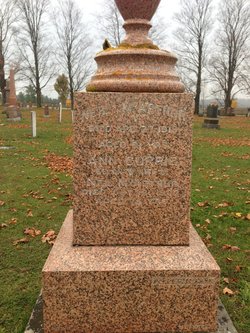
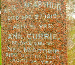
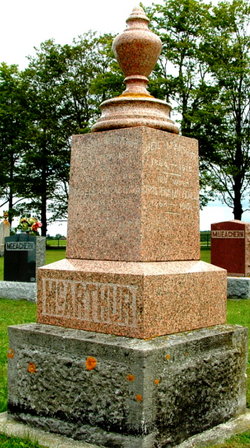
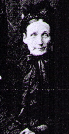
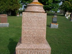
Nancy “Ann” Currie McArthur
| Birth | : | 15 Mar 1831 Isle of Islay, Argyll and Bute, Scotland |
| Death | : | 13 Oct 1903 Owen Sound, Grey County, Ontario, Canada |
| Burial | : | St. Mary's Churchyard, Nether Stowey, Sedgemoor District, England |
| Coordinate | : | 51.1502280, -3.1494270 |
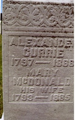
| Description | : | Ann CURRIE was a daughter of Alexander CURRIE, born on the island of Islay, Scotland, and his wife, Mary BUIE McDONALD, born on the island of Jura, Scotland. (Mary was born into the BUIE family but was raised by a McDONALD family.) Ann's known siblings were John, Alexander, Mary, Nancy, Dugald, Donald, William, and Catherine CURRIE. Ann CURRIE and Neil McARTHUR were married in Toronto, Ontario 18 Nov 1852. Their known children were John, Mary (m James Sparks ROSS), Alexander, Catherine (m Oliver James SNELL), Donald, Neil, Isabella, and William McARTHUR. |
frequently asked questions (FAQ):
-
Where is Nancy “Ann” Currie McArthur's memorial?
Nancy “Ann” Currie McArthur's memorial is located at: St. Mary's Churchyard, Nether Stowey, Sedgemoor District, England.
-
When did Nancy “Ann” Currie McArthur death?
Nancy “Ann” Currie McArthur death on 13 Oct 1903 in Owen Sound, Grey County, Ontario, Canada
-
Where are the coordinates of the Nancy “Ann” Currie McArthur's memorial?
Latitude: 51.1502280
Longitude: -3.1494270
Family Members:
Parent
Spouse
Siblings
Children

Flowers:


Nearby Cemetories:
1. St. Mary's Churchyard
Nether Stowey, Sedgemoor District, England
Coordinate: 51.1502280, -3.1494270
2. Nether Stowey Cemetery
Nether Stowey, Sedgemoor District, England
Coordinate: 51.1498667, -3.1530087
3. Over Stowey Cemetery
Over Stowey, Sedgemoor District, England
Coordinate: 51.1404020, -3.1661850
4. St Peter and St Paul Churchyard
Over Stowey, Sedgemoor District, England
Coordinate: 51.1399680, -3.1656040
5. St. Martin's Churchyard
Fiddington, Sedgemoor District, England
Coordinate: 51.1591640, -3.1229530
6. All Saints Churchyard
Dodington, West Somerset District, England
Coordinate: 51.1583770, -3.1854620
7. Stogursey Extension Cemetery
Stogursey, West Somerset District, England
Coordinate: 51.1793740, -3.1398040
8. St Andrew Churchyard
Stogursey, West Somerset District, England
Coordinate: 51.1795900, -3.1392800
9. St. Mary's Churchyard
Stringston, West Somerset District, England
Coordinate: 51.1748960, -3.1795460
10. Saint Margaret's Churchyard
Spaxton, Sedgemoor District, England
Coordinate: 51.1273090, -3.1087000
11. Spaxton Extension Cemetery
Spaxton, Sedgemoor District, England
Coordinate: 51.1267650, -3.1082920
12. All Saints Churchyard
Aisholt, Sedgemoor District, England
Coordinate: 51.1142070, -3.1532890
13. St. Mary's Churchyard
Holford, West Somerset District, England
Coordinate: 51.1627900, -3.2074238
14. Burton Baptist Chapel
Stogursey, West Somerset District, England
Coordinate: 51.1910560, -3.1560340
15. Charlynch Church of Saint Mary
Spaxton, Sedgemoor District, England
Coordinate: 51.1342600, -3.0879100
16. St. Nicholas's Churchyard
Holford, West Somerset District, England
Coordinate: 51.1902700, -3.1949170
17. Cannington Cemetery
Cannington, Sedgemoor District, England
Coordinate: 51.1500620, -3.0697070
18. St.Mary Magdalene
Stockland Bristol, Sedgemoor District, England
Coordinate: 51.1867260, -3.0886950
19. St. Andrew's Churchyard
Lilstock, West Somerset District, England
Coordinate: 51.1971070, -3.1936420
20. All Saints Churchyard
Otterhampton, Sedgemoor District, England
Coordinate: 51.1829540, -3.0796420
21. Blessed Virgin Mary Churchyard
Cannington, Sedgemoor District, England
Coordinate: 51.1500970, -3.0622850
22. Otterhampton Extension Cemetery
Otterhampton, Sedgemoor District, England
Coordinate: 51.1828490, -3.0791630
23. St. Michael's Churchyard
Enmore, Sedgemoor District, England
Coordinate: 51.1110830, -3.0872790
24. Holy Ghost Churchyard
Crowcombe, West Somerset District, England
Coordinate: 51.1232260, -3.2293260