
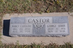
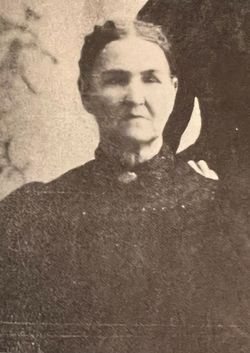
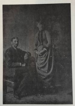
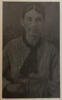
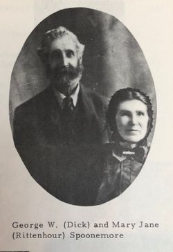
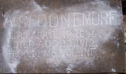
Nancy Caroline Spoonemore Castor
| Birth | : | 20 Dec 1850 Nodaway County, Missouri, USA |
| Death | : | 26 Aug 1929 Seminole County, Oklahoma, USA |
| Burial | : | St. Bartholomew's Churchyard, Great Harwood, Hyndburn Borough, England |
| Coordinate | : | 53.7900670, -2.4055460 |
| Description | : | MRS. NANCY CAROLINE CASTOR Mrs. Nancy Caroline Castor, 78, who died yesterday as a result of cancer, was buried late today in Little Cemetery. Mrs. Castor died at the home of her son, A. L. Castor, who lives a mile north and six miles east of Seminole. The funeral service, under direction of Collier Bros., was held this morning at the home of the son. Published in the Seminole Producer (Seminole, Oklahoma) - Tuesday, August 27, 1929. |
frequently asked questions (FAQ):
-
Where is Nancy Caroline Spoonemore Castor's memorial?
Nancy Caroline Spoonemore Castor's memorial is located at: St. Bartholomew's Churchyard, Great Harwood, Hyndburn Borough, England.
-
When did Nancy Caroline Spoonemore Castor death?
Nancy Caroline Spoonemore Castor death on 26 Aug 1929 in Seminole County, Oklahoma, USA
-
Where are the coordinates of the Nancy Caroline Spoonemore Castor's memorial?
Latitude: 53.7900670
Longitude: -2.4055460
Family Members:
Parent
Spouse
Siblings

Children
Flowers:


Nearby Cemetories:
1. St. Bartholomew's Churchyard
Great Harwood, Hyndburn Borough, England
Coordinate: 53.7900670, -2.4055460
2. Our Lady and Saint Hubert
Great Harwood, Hyndburn Borough, England
Coordinate: 53.7851070, -2.4009760
3. Great Harwood Cemetery
Great Harwood, Hyndburn Borough, England
Coordinate: 53.7796190, -2.4091680
4. All Saints Churchyard
Clayton-le-Moors, Hyndburn Borough, England
Coordinate: 53.7738520, -2.3881690
5. Barnes Square Weslyan Methodist Churchyard
Clayton-le-Moors, Hyndburn Borough, England
Coordinate: 53.7744350, -2.3853800
6. St Marys Burial Ground
Clayton-le-Moors, Hyndburn Borough, England
Coordinate: 53.7792778, -2.3705871
7. Church and Clayton-le-Moors Cemetery
Accrington, Hyndburn Borough, England
Coordinate: 53.7630200, -2.3804820
8. Saint Mary and All Saints Churchyard
Whalley, Ribble Valley Borough, England
Coordinate: 53.8211890, -2.4078080
9. St James Churchyard
Church, Hyndburn Borough, England
Coordinate: 53.7574640, -2.3942660
10. St. John's Churchyard
Read, Ribble Valley Borough, England
Coordinate: 53.8088800, -2.3585600
11. St James Church
Altham, Hyndburn Borough, England
Coordinate: 53.7928940, -2.3465250
12. St. Leonard Old Churchyard
Langho, Ribble Valley Borough, England
Coordinate: 53.8178590, -2.4552870
13. Whalley, Wiswell and Barrow Cemetery
Whalley, Ribble Valley Borough, England
Coordinate: 53.8308490, -2.4057280
14. Brockhall Hospital Cemetery
Brockhall Village, Ribble Valley Borough, England
Coordinate: 53.8186850, -2.4560220
15. Accrington Cemetery and Crematorium
Accrington, Hyndburn Borough, England
Coordinate: 53.7623787, -2.3508649
16. Queen Mary's Military Hospital Cemetery
Whalley, Ribble Valley Borough, England
Coordinate: 53.8337490, -2.4127930
17. Calderstones Hospital Cemetery
Whalley, Ribble Valley Borough, England
Coordinate: 53.8338710, -2.4147160
18. St. James' Parish Church
Accrington, Hyndburn Borough, England
Coordinate: 53.7519900, -2.3652600
19. Blackburn Cemetery
Blackburn, Blackburn with Darwen Unitary Authority, England
Coordinate: 53.7662430, -2.4726050
20. St Peter Churchyard
Salesbury, Ribble Valley Borough, England
Coordinate: 53.7915000, -2.4859100
21. Christ Church Churchyard
Accrington, Hyndburn Borough, England
Coordinate: 53.7478560, -2.3605820
22. St Leonard Churchyard Extension
Padiham, Burnley Borough, England
Coordinate: 53.7991800, -2.3222000
23. New Lane Baptist Chapel Chapelyard
Oswaldwistle, Hyndburn Borough, England
Coordinate: 53.7381100, -2.4049500
24. Wesleyan Methodist Chapel Chapelyard
Padiham, Burnley Borough, England
Coordinate: 53.8018980, -2.3181730