
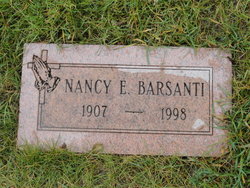
Nancy Ellen “Ella” Rodgers Barsanti
| Birth | : | 27 Jun 1907 Nebraska, USA |
| Death | : | Feb 1998 Havre, Hill County, Montana, USA |
| Burial | : | Highland Cemetery, Havre, Hill County, USA |
| Coordinate | : | 48.5463982, -109.6900024 |
| Plot | : | Lot 31 space 1 |
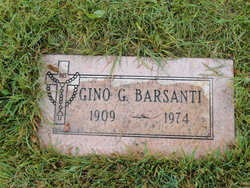
| Description | : | 1st husband John Buskirk married 1 Nov 1924, Bon Homme, Bon Homme, South Dakota 2nd Husband Gino Barsanti Great Falls Tribune (MT), 12 Feb 1998 Nancy Ellen Barsanti Havre--Nancy Ellen (Rodgers) Barsanti, 90, a retired restaurant manager, died of natural causes Monday at a Havre nursing home. Graveside services were at Highland cemetery in Havre. She was born June 21, 1907, near Royal, Neb. In 1924 she married John L. Buskirk; they later divorced. In 1955 she married Gino G. Barsanti in Great Falls. . She was a cook and housekeeper at several private homes, and... Read More |
frequently asked questions (FAQ):
-
Where is Nancy Ellen “Ella” Rodgers Barsanti's memorial?
Nancy Ellen “Ella” Rodgers Barsanti's memorial is located at: Highland Cemetery, Havre, Hill County, USA.
-
When did Nancy Ellen “Ella” Rodgers Barsanti death?
Nancy Ellen “Ella” Rodgers Barsanti death on Feb 1998 in Havre, Hill County, Montana, USA
-
Where are the coordinates of the Nancy Ellen “Ella” Rodgers Barsanti's memorial?
Latitude: 48.5463982
Longitude: -109.6900024
Family Members:
Spouse
Children

Flowers:


Nearby Cemetories:
1. Highland Cemetery
Havre, Hill County, USA
Coordinate: 48.5463982, -109.6900024
2. Calvary Cemetery
Havre, Hill County, USA
Coordinate: 48.5457000, -109.6883000
3. Mount Hope Cemetery
Havre, Hill County, USA
Coordinate: 48.5540000, -109.7050000
4. Sunset Garden Park
Havre, Hill County, USA
Coordinate: 48.5531006, -109.8019028
5. North Havre Lutheran Church Graveyard (Defunct)
Havre, Hill County, USA
Coordinate: 48.6538903, -109.6815870
6. Grainbelt Cemetery
Hill County, USA
Coordinate: 48.6828003, -109.8657990
7. Andrew S. Lohman Grave Site
Lohman, Blaine County, USA
Coordinate: 48.5903520, -109.4073350
8. East End Colony Cemetery
East End Colony, Hill County, USA
Coordinate: 48.7485000, -109.5474000
9. Hilldale Hutterite Colony Cemetery
Hilldale Colony, Hill County, USA
Coordinate: 48.7997000, -109.7872000
10. Saint Johns Catholic Cemetery
Havre, Hill County, USA
Coordinate: 48.7625008, -109.9638977
11. Saint Gabriel Cemetery
Chinook, Blaine County, USA
Coordinate: 48.6065200, -109.2531200
12. Kuper Memorial Cemetery
Chinook, Blaine County, USA
Coordinate: 48.6083100, -109.2531200
13. Rocky Boy Cemetery
Rocky Boy, Hill County, USA
Coordinate: 48.2572410, -109.7923690
14. Box Elder Cemetery
Box Elder, Hill County, USA
Coordinate: 48.3274000, -110.0095000
15. Rocky Boy Gravel Cemetery
Rocky Boy, Hill County, USA
Coordinate: 48.2427720, -109.7596500
16. Cottonwood Lutheran Church Cemetery
Havre, Hill County, USA
Coordinate: 48.4545000, -110.1748000
17. Bear Paw Battlefield
Chinook, Blaine County, USA
Coordinate: 48.3780070, -109.2121290
18. Hungry Hollow Cemetery
Blaine County, USA
Coordinate: 48.2103004, -109.4677963
19. Milk River Valley Church Graveyard
Hill County, USA
Coordinate: 48.6787180, -110.2261080
20. Hollandville Cemetery
Chinook, Blaine County, USA
Coordinate: 48.6960310, -109.1557200
21. Gildford Hill County Cemetery
Gildford, Hill County, USA
Coordinate: 48.5778008, -110.2957993
22. Prairie Chapel United Brethren Cemetery
Chinook, Blaine County, USA
Coordinate: 48.8860000, -109.3414000
23. Mennonite Brethren Cemetery
Chinook, Blaine County, USA
Coordinate: 48.8012560, -109.1980620
24. Bethel Bruderthaler Mennonite Church Cemetery
Chinook, Blaine County, USA
Coordinate: 48.7552000, -109.1345000