
| Birth | : | 18 Dec 1873 Davis County, Iowa, USA |
| Death | : | 22 Apr 1959 Ottumwa, Wapello County, Iowa, USA |
| Burial | : | Rawtenstall Cemetery, Rawtenstall, Rossendale Borough, England |
| Coordinate | : | 53.7060200, -2.2847500 |
| Plot | : | Forrest Lawn-Lot 4 |
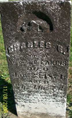
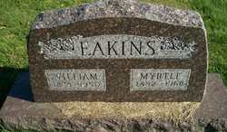
| Description | : | Johnson Funeral Home Nancy is buried with her first husband, under the name of McCall D/O William Eakins & Rose W/O George W. Haney |
frequently asked questions (FAQ):
-
Where is Nancy Etta Eakins McCall Haney's memorial?
Nancy Etta Eakins McCall Haney's memorial is located at: Rawtenstall Cemetery, Rawtenstall, Rossendale Borough, England.
-
When did Nancy Etta Eakins McCall Haney death?
Nancy Etta Eakins McCall Haney death on 22 Apr 1959 in Ottumwa, Wapello County, Iowa, USA
-
Where are the coordinates of the Nancy Etta Eakins McCall Haney's memorial?
Latitude: 53.7060200
Longitude: -2.2847500
Family Members:
Parent
Spouse

Siblings
Children
Flowers:


Nearby Cemetories:
1. Rawtenstall Cemetery
Rawtenstall, Rossendale Borough, England
Coordinate: 53.7060200, -2.2847500
2. Unitarian Chapel Burial Ground
Rossendale, Rossendale Borough, England
Coordinate: 53.7024380, -2.2856290
3. Longholme Methodist Cemetery
Rawtenstall, Rossendale Borough, England
Coordinate: 53.7009730, -2.2865000
4. Friends Burial Ground
Rossendale, Rossendale Borough, England
Coordinate: 53.7091000, -2.2757160
5. Broadleys Garden
Rawtenstall, Rossendale Borough, England
Coordinate: 53.7176321, -2.2904764
6. Burnley Road Cemetery, Reedsholme, Rossendale
Rossendale Borough, England
Coordinate: 53.7178398, -2.2904316
7. Crawshawbooth Quaker Burial Ground
Crawshawbooth, Rossendale Borough, England
Coordinate: 53.7242420, -2.2879400
8. Bethlehem Chapel Graveyard
Newchurch, Rossendale Borough, England
Coordinate: 53.6976970, -2.2522620
9. St. Nicholas Churchyard
Newchurch, Rossendale Borough, England
Coordinate: 53.6972220, -2.2524660
10. Saint Anne's Churchyard Edgeside
Waterfoot, Rossendale Borough, England
Coordinate: 53.7031600, -2.2482700
11. Newchurch Methodist Churchyard
Newchurch, Rossendale Borough, England
Coordinate: 53.6983460, -2.2501260
12. Ebenezer Baptist Chapel Chapelyard
Haslingden, Rossendale Borough, England
Coordinate: 53.7053960, -2.3230070
13. King Street Methodist Chapel Chapelyard
Haslingden, Rossendale Borough, England
Coordinate: 53.7066710, -2.3231330
14. St James Churchyard
Haslingden, Rossendale Borough, England
Coordinate: 53.7084000, -2.3259550
15. St. Mary and All Saints Churchyard
Goodshaw, Rossendale Borough, England
Coordinate: 53.7315270, -2.2828940
16. Saint Michael on the Hill Churchyard
Lumb, Rossendale Borough, England
Coordinate: 53.7201000, -2.2479300
17. Goodshaw Particular Baptist Chapel Graveyard
Goodshaw, Rossendale Borough, England
Coordinate: 53.7328210, -2.2815530
18. Lumb Baptist Church Cemetery
Waterfoot, Rossendale Borough, England
Coordinate: 53.7229340, -2.2455170
19. Rehoboth Chapel
Goodshaw, Rossendale Borough, England
Coordinate: 53.7355870, -2.2914730
20. Saint Thomas Churchyard
Helmshore, Rossendale Borough, England
Coordinate: 53.6870400, -2.3300000
21. Edenfield Parish Churchyard
Ramsbottom, Metropolitan Borough of Bury, England
Coordinate: 53.6742799, -2.3069304
22. Holden Hall Cemetery
Haslingden, Rossendale Borough, England
Coordinate: 53.6989870, -2.3427780
23. Haslingden Cemetery
Haslingden, Rossendale Borough, England
Coordinate: 53.6989500, -2.3427700
24. Providence Free United Methodist Graveyard
Crawshawbooth, Rossendale Borough, England
Coordinate: 53.7442070, -2.2825700