
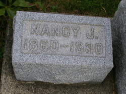
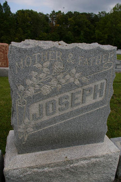
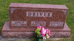
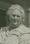
Nancy Jane Driver Joseph
| Birth | : | 13 Jul 1860 |
| Death | : | 23 Dec 1930 |
| Burial | : | Westonzoyland Cemetery New, Westonzoyland, Sedgemoor District, England |
| Coordinate | : | 51.1096271, -2.9349336 |
frequently asked questions (FAQ):
-
Where is Nancy Jane Driver Joseph's memorial?
Nancy Jane Driver Joseph's memorial is located at: Westonzoyland Cemetery New, Westonzoyland, Sedgemoor District, England.
-
When did Nancy Jane Driver Joseph death?
Nancy Jane Driver Joseph death on 23 Dec 1930 in
-
Where are the coordinates of the Nancy Jane Driver Joseph's memorial?
Latitude: 51.1096271
Longitude: -2.9349336
Family Members:
Parent

Spouse
Siblings
Children
Flowers:


Nearby Cemetories:
1. Westonzoyland Cemetery New
Westonzoyland, Sedgemoor District, England
Coordinate: 51.1096271, -2.9349336
2. The Old Chapel
Westonzoyland, Sedgemoor District, England
Coordinate: 51.1077425, -2.9285237
3. St. Mary's Churchyard
Westonzoyland, Sedgemoor District, England
Coordinate: 51.1087000, -2.9273800
4. Westonzoyland Cemetery
Westonzoyland, Sedgemoor District, England
Coordinate: 51.1078900, -2.9264440
5. Church of the Blessed Virgin Mary Churchyard
Chedzoy, Sedgemoor District, England
Coordinate: 51.1344600, -2.9429400
6. Northmoor Green St. Peter & St. John Churchyard
North Petherton, Sedgemoor District, England
Coordinate: 51.0841694, -2.9486911
7. Sutton Mallet Churchyard
Sutton Mallet, Sedgemoor District, England
Coordinate: 51.1282540, -2.8974536
8. Holy Cross Churchyard
Middlezoy, Sedgemoor District, England
Coordinate: 51.0937200, -2.8941260
9. St. Francis Churchyard
Stawell, Sedgemoor District, England
Coordinate: 51.1404200, -2.9046660
10. Ebenezer Chapelyard
Burrowbridge, Taunton Deane Borough, England
Coordinate: 51.0727744, -2.9222989
11. St Michael Churchyard
Burrowbridge, Taunton Deane Borough, England
Coordinate: 51.0698090, -2.9174960
12. Saint Michael & All Angels Churchyard
Bawdrip, Sedgemoor District, England
Coordinate: 51.1517260, -2.9429330
13. Othery Cemetery
Othery, Sedgemoor District, England
Coordinate: 51.0771222, -2.8906189
14. St John The Baptist Churchyard
Bridgwater, Sedgemoor District, England
Coordinate: 51.1311160, -2.9969910
15. Former Holy Trinity Churchyard
Bridgwater, Sedgemoor District, England
Coordinate: 51.1261850, -3.0021850
16. St. John Bristol Road Cemetery
Bridgwater, Sedgemoor District, England
Coordinate: 51.1391470, -2.9901660
17. Bridgwater Baptist Church
Bridgwater, Sedgemoor District, England
Coordinate: 51.1272613, -3.0046282
18. St. Mary's Churchyard
Bridgwater, Sedgemoor District, England
Coordinate: 51.1277430, -3.0050330
19. Gray Friar's
Bridgwater, Sedgemoor District, England
Coordinate: 51.1264260, -3.0065160
20. Heathfield Cemetery
North Petherton, Sedgemoor District, England
Coordinate: 51.0957200, -3.0081100
21. Quaker Burial Ground
Bridgwater, Sedgemoor District, England
Coordinate: 51.1261740, -3.0078020
22. St. Mary's Churchyard
Cossington, Sedgemoor District, England
Coordinate: 51.1580085, -2.9213149
23. Blessed Virgin Mary Churchyard
Moorlinch, Sedgemoor District, England
Coordinate: 51.1280000, -2.8616000
24. Athelney Abbey (Defunct)
Athelney, Sedgemoor District, England
Coordinate: 51.0593000, -2.9345800