
| Birth | : | 31 Jan 1920 Big Creek Township, Stokes County, North Carolina, USA |
| Death | : | 27 Dec 2004 Pinnacle, Stokes County, North Carolina, USA |
| Burial | : | Pilot Mountain City Cemetery, Pilot Mountain, Surry County, USA |
| Coordinate | : | 36.3918343, -80.4809418 |
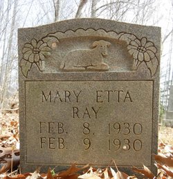
| Description | : | PINNACLE, NC ~ Mrs. Erline Ray Watson, 84, widow of John Wesley Watson, of Old Winston Road in Pinnacle passed away Monday, Dec. 27, 2004, at her home. She was born Jan. 31, 1920, in Stokes County to Charlie Meadows and Mary Etta Smith Ray. She was retired from the Forsyth County Public Library system. She was a member of Pinnacle United Methodist Church, serving as a lifelong Sunday school teacher, and was a member of the United Methodist Women. Mrs. Watson was one of the original founding members of Maple Springs United Methodist Church in Winston-Salem. She was an... Read More |
frequently asked questions (FAQ):
-
Where is Nannie Erline Ray Watson's memorial?
Nannie Erline Ray Watson's memorial is located at: Pilot Mountain City Cemetery, Pilot Mountain, Surry County, USA.
-
When did Nannie Erline Ray Watson death?
Nannie Erline Ray Watson death on 27 Dec 2004 in Pinnacle, Stokes County, North Carolina, USA
-
Where are the coordinates of the Nannie Erline Ray Watson's memorial?
Latitude: 36.3918343
Longitude: -80.4809418
Family Members:
Parent

Spouse

Siblings
Children
Flowers:


Nearby Cemetories:
1. Pilot Mountain City Cemetery
Pilot Mountain, Surry County, USA
Coordinate: 36.3918343, -80.4809418
2. Green Family Cemetery
Pilot Mountain, Surry County, USA
Coordinate: 36.3956630, -80.4833990
3. Lovells Chapel Church Cemetery
Pilot Mountain, Surry County, USA
Coordinate: 36.3879160, -80.4652290
4. Tucker-Stone Cemetery
Surry County, USA
Coordinate: 36.3990000, -80.4954167
5. Bennett Cemetery
Pilot Mountain, Surry County, USA
Coordinate: 36.3988991, -80.4957962
6. Rescue Baptist Church Cemetery
Pilot Mountain, Surry County, USA
Coordinate: 36.3898080, -80.4613240
7. Beulahland Baptist Church Cemetery
Pilot Mountain, Surry County, USA
Coordinate: 36.4037330, -80.4954900
8. John Denny Cemetery
Pilot Mountain, Surry County, USA
Coordinate: 36.3755989, -80.4910965
9. John Wesley Hill Cemetery
Pilot Mountain, Surry County, USA
Coordinate: 36.4000282, -80.5012817
10. Stone Family Cemetery
Pilot Mountain, Surry County, USA
Coordinate: 36.3695070, -80.4689960
11. Friendly Chapel Church Cemetery
Pilot Mountain, Surry County, USA
Coordinate: 36.3635292, -80.4816132
12. Whitakers Chapel United Methodist Church Cemetery
Pilot Mountain, Surry County, USA
Coordinate: 36.3763008, -80.5105057
13. Sulphur Springs Baptist Church Cemetery
Pilot Mountain, Surry County, USA
Coordinate: 36.4074440, -80.5108871
14. Lawrence Cemetery
Pilot Mountain, Surry County, USA
Coordinate: 36.3716080, -80.4537230
15. Hills Presbyterian Church Cemetery
Hills Grove, Surry County, USA
Coordinate: 36.4234161, -80.4621658
16. Captain Bill Wilson Family Cemetery
Brims Grove, Stokes County, USA
Coordinate: 36.4168750, -80.4405590
17. Worth Cemetery
Ararat, Surry County, USA
Coordinate: 36.4180130, -80.5205710
18. Jessup Family Cemetery
Pilot Mountain, Surry County, USA
Coordinate: 36.4282990, -80.4563980
19. McDaniel Family Cemetery
Pilot Mountain, Surry County, USA
Coordinate: 36.4285800, -80.4560500
20. Carey Bird Denny Cemetery
Pilot Mountain, Surry County, USA
Coordinate: 36.3582000, -80.5177500
21. Hills Village Family Cemetery
Hills Grove, Surry County, USA
Coordinate: 36.4352200, -80.4594500
22. Ararat-Cedar Hill Primitive Baptist Church
Cedar Hill, Surry County, USA
Coordinate: 36.3671265, -80.5306778
23. Cox Cemetery
Pilot Mountain, Surry County, USA
Coordinate: 36.3743890, -80.5353890
24. Brim Family Cemetery
Stokes County, USA
Coordinate: 36.4026952, -80.4201749