

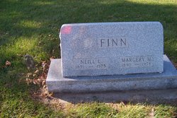
Neill Leonard Finn
| Birth | : | 4 Oct 1891 Clarion, Wright County, Iowa, USA |
| Death | : | 9 Sep 1975 Estherville, Emmet County, Iowa, USA |
| Burial | : | Lincoln Township Cemetery, Dolliver, Emmet County, USA |
| Coordinate | : | 43.4441986, -94.6204987 |
| Description | : | Neill Finn Estherville – Funeral services for Neill [Leonard] Finn, 83, Dolliver, will be at 2 p.m. Friday at the Fuhrman Funeral Home, Estherville, with the Msgr. James Duhigg officiating and burial at the Dolliver Cemetery. He died Tuesday [September 9, 1975] at Holy Family Hospital, Estherville. Mr. Finn was born Oct. 4, 1891 [per WWI draft record, 1893] at Clarion to Mr. and Mrs. Thomas Finn and was married to Margery Hilton in Osage on Oct. 71, 1923. He lived in Dolliver for over 50 years where he served as mayor, operated a general store for 26 years and was an... Read More |
frequently asked questions (FAQ):
-
Where is Neill Leonard Finn's memorial?
Neill Leonard Finn's memorial is located at: Lincoln Township Cemetery, Dolliver, Emmet County, USA.
-
When did Neill Leonard Finn death?
Neill Leonard Finn death on 9 Sep 1975 in Estherville, Emmet County, Iowa, USA
-
Where are the coordinates of the Neill Leonard Finn's memorial?
Latitude: 43.4441986
Longitude: -94.6204987
Family Members:

Flowers:


Nearby Cemetories:
1. Lincoln Township Cemetery
Dolliver, Emmet County, USA
Coordinate: 43.4441986, -94.6204987
2. Palestine Cemetery
Dolliver, Emmet County, USA
Coordinate: 43.4880000, -94.6408000
3. Swan Lake Township Cemetery
Maple Hill, Emmet County, USA
Coordinate: 43.3850746, -94.6381378
4. Tenhassen Cemetery
Ceylon, Martin County, USA
Coordinate: 43.5293999, -94.5877991
5. Center Township Cemetery
Emmet County, USA
Coordinate: 43.3608000, -94.6790000
6. Ellsworth Cemetery
Emmet County, USA
Coordinate: 43.5005989, -94.7249985
7. Saint Marys Catholic Cemetery
Armstrong, Emmet County, USA
Coordinate: 43.3980000, -94.5048000
8. Armstrong Grove Cemetery
Armstrong, Emmet County, USA
Coordinate: 43.3985696, -94.5041425
9. Lake Belt Cemetery
Ceylon, Martin County, USA
Coordinate: 43.5353012, -94.6742020
10. Mount Calvary Cemetery
Armstrong, Emmet County, USA
Coordinate: 43.3850000, -94.5028000
11. German Evangelical Cemetery
Wilbert, Martin County, USA
Coordinate: 43.5325600, -94.5419000
12. Prosser Cemetery
Estherville, Emmet County, USA
Coordinate: 43.4422000, -94.7783000
13. Saint Pauls Lutheran Church Cemetery
Wilbert, Martin County, USA
Coordinate: 43.5444500, -94.5395800
14. Center Chain Cemetery
Martin County, USA
Coordinate: 43.5224991, -94.4483032
15. Norwegian Cemetery
Estherville, Emmet County, USA
Coordinate: 43.4291992, -94.8261032
16. Estherville Lutheran Cemetery
Estherville, Emmet County, USA
Coordinate: 43.4298000, -94.8263000
17. East Side Memorial Cemetery
Estherville, Emmet County, USA
Coordinate: 43.4267750, -94.8265600
18. East Side Cemetery
Estherville, Emmet County, USA
Coordinate: 43.4068985, -94.8264008
19. High Lake Jack Creek Cemetery
Wallingford, Emmet County, USA
Coordinate: 43.3006500, -94.7000620
20. Saint Patricks Cemetery
Estherville, Emmet County, USA
Coordinate: 43.3843994, -94.8283005
21. Lake Fremont Cemetery
Dunnell, Martin County, USA
Coordinate: 43.5691986, -94.7746964
22. Wallingford Lutheran Cemetery
Wallingford, Emmet County, USA
Coordinate: 43.3128014, -94.7731018
23. Oak Hill Cemetery
Estherville, Emmet County, USA
Coordinate: 43.3986015, -94.8518982
24. Memorial Cemetery
Ringsted, Emmet County, USA
Coordinate: 43.3009070, -94.4814670