
| Birth | : | 1826 Tennessee, USA |
| Death | : | 1881 Devonia, Anderson County, Tennessee, USA |
| Burial | : | Rempstone, St Peter in the Rushes, Rempstone, Rushcliffe Borough, England |
| Coordinate | : | 52.8191600, -1.1614400 |
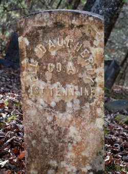
| Inscription | : | Co. A. 1st Tenn. Inf. |
| Description | : | Son of Daniel Daugherty Thanks to vjk (#939622) for father's link |
frequently asked questions (FAQ):
-
Where is Noah D. Daugherty's memorial?
Noah D. Daugherty's memorial is located at: Rempstone, St Peter in the Rushes, Rempstone, Rushcliffe Borough, England.
-
When did Noah D. Daugherty death?
Noah D. Daugherty death on 1881 in Devonia, Anderson County, Tennessee, USA
-
Where are the coordinates of the Noah D. Daugherty's memorial?
Latitude: 52.8191600
Longitude: -1.1614400
Family Members:
Parent

Spouse
Siblings
Children
Flowers:


Nearby Cemetories:
1. Rempstone, St Peter in the Rushes
Rempstone, Rushcliffe Borough, England
Coordinate: 52.8191600, -1.1614400
2. All Saints Churchyard
Rempstone, Rushcliffe Borough, England
Coordinate: 52.8149800, -1.1477700
3. Rempstone Anabaptist Burial Ground
Rempstone, Rushcliffe Borough, England
Coordinate: 52.8179800, -1.1426400
4. St Giles Churchyard
Costock, Rushcliffe Borough, England
Coordinate: 52.8326300, -1.1489100
5. Hoton Burial Ground
Hoton, Charnwood Borough, England
Coordinate: 52.7983472, -1.1500767
6. Wymeswold Rempstone Road Cemetery
Wymeswold, Charnwood Borough, England
Coordinate: 52.8084600, -1.1180480
7. St. Andrew's Churchyard
Prestwold, Charnwood Borough, England
Coordinate: 52.7875000, -1.1446400
8. St. Marys Churchyard
Wymeswold, Charnwood Borough, England
Coordinate: 52.8055010, -1.1067320
9. St Helena Churchyard
West Leake, Rushcliffe Borough, England
Coordinate: 52.8330920, -1.2171267
10. Holy Trinity Churchyard
Wysall, Rushcliffe Borough, England
Coordinate: 52.8383300, -1.1044200
11. Burton-on-the-Wolds Burial Ground
Burton-on-the-Wolds, Charnwood Borough, England
Coordinate: 52.7864470, -1.1207120
12. Prestwold Natural Burial Ground
Loughborough, Charnwood Borough, England
Coordinate: 52.7779510, -1.1538520
13. St Mary the Virgin Churchyard
Bunny, Rushcliffe Borough, England
Coordinate: 52.8606758, -1.1354220
14. All Saints with Holy Trinity Churchyard
Loughborough, Charnwood Borough, England
Coordinate: 52.7743880, -1.2035500
15. St. Anne's Churchyard
Sutton Bonington, Rushcliffe Borough, England
Coordinate: 52.8206200, -1.2485400
16. St Mary Churchyard
Walton-on-the-Wolds, Charnwood Borough, England
Coordinate: 52.7712900, -1.1241310
17. Marle Pit Hill Cemetery
Sutton Bonington, Rushcliffe Borough, England
Coordinate: 52.8241820, -1.2525970
18. St. Michael's Churchyard
Sutton Bonington, Rushcliffe Borough, England
Coordinate: 52.8240654, -1.2529907
19. Barrow-Upon-Soar Cemetery
Barrow-upon-Soar, Charnwood Borough, England
Coordinate: 52.7620220, -1.1585640
20. All Saints' Church Dishley
Hathern, Charnwood Borough, England
Coordinate: 52.7860705, -1.2412000
21. Emmanuel Churchyard
Loughborough, Charnwood Borough, England
Coordinate: 52.7668830, -1.2108020
22. Church of St Mary and All Saints
Willoughby-on-the-Wolds, Rushcliffe Borough, England
Coordinate: 52.8227780, -1.0608330
23. St. Peters & St. Paul Cemetery
Hathern, Charnwood Borough, England
Coordinate: 52.7970560, -1.2558040
24. Greenhill Rise Cemetery
Hathern, Charnwood Borough, England
Coordinate: 52.7990180, -1.2576160