
| Birth | : | 8 Sep 1916 Clay County, Tennessee, USA |
| Death | : | 8 Apr 2001 Gainesboro, Jackson County, Tennessee, USA |
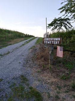
| Burial | : | Jonestown Cemetery, Clay County, USA |
| Coordinate | : | 36.5619011, -85.6921997 |
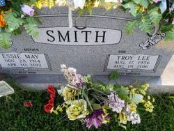
| Description | : | SMITH, Norman Leslie "Major" Age 84. Sunday, April 8, 2001. Services 1 p.m., Tuesday, April 10, 2001. UPTON FUNERAL HOME, (931)243-3164 Lebanon, Tn. wife Essie Mae Smith Essie Mae Smith, 97, of Gainesboro passed away April 30 at her residence. Graveside services were held May 1 at the Jonestown Cemetery. Upton Funeral Home was in charge of the arrangements. Essie Mae Smith was born Nov. 28, 1914 in Clay County. She was a homemaker and a member of the Church of Christ. She was preceded in death by her parents, Willie B. Bill and Flora G. Denton Armer; husband, Norman Leslie Mage Smith; brothers,... Read More |
frequently asked questions (FAQ):
-
Where is Norman Leslie “Major” Smith's memorial?
Norman Leslie “Major” Smith's memorial is located at: Jonestown Cemetery, Clay County, USA.
-
When did Norman Leslie “Major” Smith death?
Norman Leslie “Major” Smith death on 8 Apr 2001 in Gainesboro, Jackson County, Tennessee, USA
-
Where are the coordinates of the Norman Leslie “Major” Smith's memorial?
Latitude: 36.5619011
Longitude: -85.6921997
Family Members:
Parent
Spouse
Siblings
Children
Flowers:


Nearby Cemetories:
1. Jonestown Cemetery
Clay County, USA
Coordinate: 36.5619011, -85.6921997
2. Cherry Denton Cemetery
Clay County, USA
Coordinate: 36.5512200, -85.6971200
3. Hinson Cemetery
Moss, Clay County, USA
Coordinate: 36.5756750, -85.7020010
4. Pricetown Cemetery
Clay County, USA
Coordinate: 36.5422500, -85.6750670
5. Smith Cemetery
Pine Hill, Clay County, USA
Coordinate: 36.5714930, -85.6568170
6. James H. Cherry Family Cemetery
Clay County, USA
Coordinate: 36.5453700, -85.7266000
7. Eads-Denton Cemetery
Pine Hill, Clay County, USA
Coordinate: 36.5644207, -85.6503187
8. Pitcock Cemetery
Clay County, USA
Coordinate: 36.5992012, -85.6911011
9. Cherry Cemetery #3
Oak Grove, Clay County, USA
Coordinate: 36.6015000, -85.7100300
10. Mount Vernon Cemetery
Miles Crossroads, Clay County, USA
Coordinate: 36.5435982, -85.7403030
11. Kendall Cemetery
Moss, Clay County, USA
Coordinate: 36.5672540, -85.6362650
12. Liberty Church Cemetery
Boles, Clay County, USA
Coordinate: 36.6010850, -85.6496830
13. Clementsville Cemetery
Clementsville, Clay County, USA
Coordinate: 36.6132300, -85.7146410
14. Browning Cemetery
Clay County, USA
Coordinate: 36.5578003, -85.7602997
15. Cherry Family Cemetery #02
Clay County, USA
Coordinate: 36.5071260, -85.6685290
16. Moore Cemetery #1
Moss, Clay County, USA
Coordinate: 36.6164920, -85.6636620
17. Moss Cemetery
Moss, Clay County, USA
Coordinate: 36.5911210, -85.6214460
18. Macedonia Cemetery
Moss, Clay County, USA
Coordinate: 36.5643997, -85.6110992
19. Moore Cemetery
Moss, Clay County, USA
Coordinate: 36.6113400, -85.6374980
20. Willhoite-Curtis Cemetery
Tompkinsville, Monroe County, USA
Coordinate: 36.6182208, -85.6442948
21. Hermitage Springs Cemetery
Hermitage Springs, Clay County, USA
Coordinate: 36.5823500, -85.7750900
22. Edna Lee Biblery
Bakerton, Clay County, USA
Coordinate: 36.5048730, -85.7420270
23. Beech Grove Cemetery
Harlan Crossroads, Monroe County, USA
Coordinate: 36.6319000, -85.6809000
24. Old Bowman Cemetery
Gamaliel, Monroe County, USA
Coordinate: 36.6289830, -85.7204190