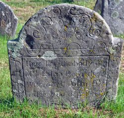
| Birth | : | 27 May 1728 Norwich, New London County, Connecticut, USA |
| Death | : | 13 Apr 1795 Franklin, New London County, Connecticut, USA |
| Burial | : | Saint Alphonsus Cemetery, Saint Joseph, Daviess County, USA |
| Coordinate | : | 37.6948800, -87.3247700 |
| Inscription | : | In memory of Mr Obadiah Smith who died April 13th 1795 in __ 68th year of his age. |
| Description | : | Son of Joshua (whose burial is unknown) and Edna Hazen Smith |
frequently asked questions (FAQ):
-
Where is Obadiah Smith's memorial?
Obadiah Smith's memorial is located at: Saint Alphonsus Cemetery, Saint Joseph, Daviess County, USA.
-
When did Obadiah Smith death?
Obadiah Smith death on 13 Apr 1795 in Franklin, New London County, Connecticut, USA
-
Where are the coordinates of the Obadiah Smith's memorial?
Latitude: 37.6948800
Longitude: -87.3247700
Family Members:
Parent
Spouse
Siblings
Children
Flowers:
Nearby Cemetories:
1. Saint Alphonsus Cemetery
Saint Joseph, Daviess County, USA
Coordinate: 37.6948800, -87.3247700
2. Mount Saint Joseph Cemetery
Maple Mount, Daviess County, USA
Coordinate: 37.6931000, -87.3216570
3. Travis Cemetery
Saint Joseph, Daviess County, USA
Coordinate: 37.6777992, -87.3469009
4. Jewell Cemetery
Saint Joseph, Daviess County, USA
Coordinate: 37.6804199, -87.3699799
5. McCain Cemetery
Curdsville, Daviess County, USA
Coordinate: 37.7322006, -87.3480988
6. Old Macedonia Cemetery
Panther, Daviess County, USA
Coordinate: 37.6530000, -87.3042000
7. Pleasant Hill Cumberland Presb. Church Cemetery
Elba, McLean County, USA
Coordinate: 37.6660690, -87.3741989
8. Calhoon Curdsville Cemetery
Curdsville, Daviess County, USA
Coordinate: 37.7440000, -87.3020000
9. Welden Cemetery
Hebbardsville, Henderson County, USA
Coordinate: 37.7503200, -87.3253800
10. Old Macedonia Cemetery
Daviess County, USA
Coordinate: 37.6489000, -87.2822000
11. New Salem Primitive Baptist Church Cemetery
Beech Grove, McLean County, USA
Coordinate: 37.6372795, -87.3351974
12. Saint Raphael Cemetery
West Louisville, Daviess County, USA
Coordinate: 37.7033900, -87.2489000
13. Delaware Church Cemetery
Delaware, Daviess County, USA
Coordinate: 37.6859130, -87.4041040
14. Saint Raphael Original Log Church and Cemetery
West Louisville, Daviess County, USA
Coordinate: 37.7009600, -87.2442900
15. Mount Liberty Baptist Church Cemetery
Wyman, McLean County, USA
Coordinate: 37.6312256, -87.3094635
16. Hitchcock Family Cemetery
Sorgho, Daviess County, USA
Coordinate: 37.7423261, -87.2686245
17. Beulah General Baptist Church Cemetery
McLean County, USA
Coordinate: 37.6285706, -87.3355026
18. Little Flock Cemetery
West Louisville, Daviess County, USA
Coordinate: 37.6369900, -87.2733300
19. Hazelwood Cemetery
Hebbardsville, Henderson County, USA
Coordinate: 37.7596110, -87.3692780
20. Little Flock Baptist Cemetery
Sorgho, Daviess County, USA
Coordinate: 37.7573600, -87.2687700
21. Mount Zion Methodist Episcopal Church Cemetery
Panther, Daviess County, USA
Coordinate: 37.6638700, -87.2325500
22. Sorgho Baptist Church Cemetery
Sorgho, Daviess County, USA
Coordinate: 37.7552700, -87.2588600
23. Brushy Fork Cemetery
Panther, Daviess County, USA
Coordinate: 37.6375999, -87.2545013
24. Bethel Cemetery
Hebbardsville, Henderson County, USA
Coordinate: 37.7684898, -87.3658829


