
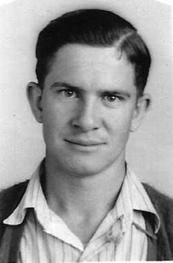
Olnia Floyd Allen
| Birth | : | 18 Jan 1919 Osage Township, Morgan County, Missouri, USA |
| Death | : | 4 Sep 1944 France |
| Burial | : | St. Martin Churchyard, Trimley St Martin, Suffolk Coastal District, England |
| Coordinate | : | 51.9851680, 1.3142220 |
frequently asked questions (FAQ):
-
Where is Olnia Floyd Allen's memorial?
Olnia Floyd Allen's memorial is located at: St. Martin Churchyard, Trimley St Martin, Suffolk Coastal District, England.
-
When did Olnia Floyd Allen death?
Olnia Floyd Allen death on 4 Sep 1944 in France
-
Where are the coordinates of the Olnia Floyd Allen's memorial?
Latitude: 51.9851680
Longitude: 1.3142220
Family Members:
Parent

Siblings

Flowers:


Nearby Cemetories:
1. St. Mary's Parish Churchyard
Trimley St Mary, Suffolk Coastal District, England
Coordinate: 51.9846250, 1.3145370
2. Walton Cemetery
Felixstowe, Suffolk Coastal District, England
Coordinate: 51.9723000, 1.3412500
3. St Ethelbert Churchyard
Falkenham, Suffolk Coastal District, England
Coordinate: 52.0023900, 1.3401700
4. St. Mary and St. Martin Church Cemetery
Kirton, Suffolk Coastal District, England
Coordinate: 52.0090070, 1.3226860
5. Felixstowe Cemetery
Felixstowe, Suffolk Coastal District, England
Coordinate: 51.9649780, 1.3368740
6. War Memorial
Felixstowe, Suffolk Coastal District, England
Coordinate: 51.9593220, 1.3493472
7. Ss Peter and Paul Churchyard
Felixstowe, Suffolk Coastal District, England
Coordinate: 51.9716420, 1.3678780
8. Shotley Royal Naval Cemetery
Shotley, Babergh District, England
Coordinate: 51.9780006, 1.2569460
9. St. Mary's Church Cemetery
Shotley, Babergh District, England
Coordinate: 51.9773400, 1.2562500
10. St Mary Churchyard
Shotley, Babergh District, England
Coordinate: 51.9776180, 1.2558960
11. St Peter's Churchyard
Levington, Suffolk Coastal District, England
Coordinate: 52.0047690, 1.2539900
12. St Nicholas Churchyard
Harwich, Tendring District, England
Coordinate: 51.9457150, 1.2886510
13. Landguard Fort Graveyard
Felixstowe, Suffolk Coastal District, England
Coordinate: 51.9405105, 1.3199968
14. All Saints Parish Church
Hemley, Suffolk Coastal District, England
Coordinate: 52.0324550, 1.3304610
15. All Saints Churchyard
Ramsholt, Suffolk Coastal District, England
Coordinate: 52.0294500, 1.3617700
16. St Mary Churchyard
Bucklesham, Suffolk Coastal District, England
Coordinate: 52.0316100, 1.2699200
17. St. Mary's Churchyard
Newbourne, Suffolk Coastal District, England
Coordinate: 52.0392970, 1.3127700
18. St Mary's Church
Erwarton (Arwarton), Babergh District, England
Coordinate: 51.9661220, 1.2315200
19. Seven Hills Crematorium
Nacton, Suffolk Coastal District, England
Coordinate: 52.0252130, 1.2489840
20. Parkeston Cemetery
Parkeston, Tendring District, England
Coordinate: 51.9384300, 1.2579700
21. St Martin Churchyard
Nacton, Suffolk Coastal District, England
Coordinate: 52.0113690, 1.2295000
22. St John the Baptist Churchyard
Brightwell, Suffolk Coastal District, England
Coordinate: 52.0445610, 1.2792080
23. Baptist Chapel's Burial Ground
Chelmondiston, Babergh District, England
Coordinate: 51.9898720, 1.2114610
24. All Saints Churchyard
Dovercourt, Tendring District, England
Coordinate: 51.9334060, 1.2546450