
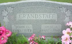
Opal Anthel Oliver Grandstaff
| Birth | : | 23 Jul 1907 Carter County, Missouri, USA |
| Death | : | 16 Jul 1968 Birch Tree, Shannon County, Missouri, USA |
| Burial | : | Ebeneezer Chapel, Biddenden, Ashford Borough, England |
| Coordinate | : | 51.1383320, 0.6416030 |
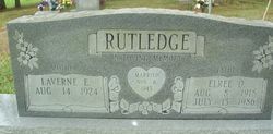
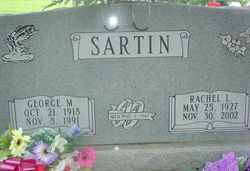
| Description | : | OBITUARY OPAL ANTHAL OLIVER GRANDSTAFF - Daughter of the late John and Etta OLIVER, was born July 23, 1907 at Van Buren, Carter Co MO and departed this life July 16, 1968 at her home in Birch Tree Shannon Co MO at the age of 60 years 11 months and 23 days. She was united in marriage to John Oren GRANDSTAFF on May 24, 1923. To this union six children were born: four daughters, Mrs. Elree RUTLEDGE and Mrs. George SARTIN of Birch Tree Shannon Co MO; Mrs. Johnny Ivan COOLEY and Mrs. Ernie YEARWOOD of Winona... Read More |
frequently asked questions (FAQ):
-
Where is Opal Anthel Oliver Grandstaff's memorial?
Opal Anthel Oliver Grandstaff's memorial is located at: Ebeneezer Chapel, Biddenden, Ashford Borough, England.
-
When did Opal Anthel Oliver Grandstaff death?
Opal Anthel Oliver Grandstaff death on 16 Jul 1968 in Birch Tree, Shannon County, Missouri, USA
-
Where are the coordinates of the Opal Anthel Oliver Grandstaff's memorial?
Latitude: 51.1383320
Longitude: 0.6416030
Family Members:
Parent
Spouse

Siblings
Children


Nearby Cemetories:
1. All Saints Churchyard
Biddenden, Ashford Borough, England
Coordinate: 51.1150740, 0.6403990
2. St. Michael the Archangel Churchyard
Smarden, Ashford Borough, England
Coordinate: 51.1490030, 0.6861940
3. Headcorn Baptist Churchyard
Headcorn, Maidstone Borough, England
Coordinate: 51.1674156, 0.6247670
4. Headcorn Parish Burial Ground
Headcorn, Maidstone Borough, England
Coordinate: 51.1671257, 0.6204750
5. Headcorn Methodist Churchyard
Headcorn, Maidstone Borough, England
Coordinate: 51.1674940, 0.6205670
6. Headcorn War Memorial
Headcorn, Maidstone Borough, England
Coordinate: 51.1677480, 0.6212560
7. St. Mary's Churchyard
Frittenden, Tunbridge Wells Borough, England
Coordinate: 51.1391190, 0.5904720
8. St. Peter and St. Paul Churchyard
Headcorn, Maidstone Borough, England
Coordinate: 51.1678543, 0.6203760
9. Frittenden Burial Gound
Frittenden, Tunbridge Wells Borough, England
Coordinate: 51.1428480, 0.5870820
10. Sissinghurst Cemetery
Sissinghurst, Tunbridge Wells Borough, England
Coordinate: 51.1095310, 0.5629240
11. St. Mary the Virgin Churchyard
High Halden, Ashford Borough, England
Coordinate: 51.1028950, 0.7148620
12. All Saints Church
Staplehurst, Maidstone Borough, England
Coordinate: 51.1582160, 0.5527170
13. St. Michael and All Angels Churchyard
Tenterden, Ashford Borough, England
Coordinate: 51.0867424, 0.6894140
14. Marian Martyrs Memorial
Staplehurst, Maidstone Borough, England
Coordinate: 51.1649780, 0.5523900
15. Egerton Free Church Graveyard
Egerton, Ashford Borough, England
Coordinate: 51.1871830, 0.7050080
16. Cranbrook Cemetery
Cranbrook, Tunbridge Wells Borough, England
Coordinate: 51.0962250, 0.5541360
17. St. Margaret's Churchyard
Bethersden, Ashford Borough, England
Coordinate: 51.1291440, 0.7538760
18. Unitarian Old Meeting House
Tenterden, Ashford Borough, England
Coordinate: 51.0717468, 0.6906880
19. Tenterden Cemetery
Tenterden, Ashford Borough, England
Coordinate: 51.0676820, 0.6737140
20. Station Road Extension
Tenterden, Ashford Borough, England
Coordinate: 51.0686640, 0.6852830
21. St. Mildred's Churchyard
Tenterden, Ashford Borough, England
Coordinate: 51.0686264, 0.6870960
22. St Dunstan's Churchyard
Cranbrook, Tunbridge Wells Borough, England
Coordinate: 51.0973030, 0.5363690
23. St David's Bridge Strict Baptist Chapel
Cranbrook, Tunbridge Wells Borough, England
Coordinate: 51.0953430, 0.5378980
24. All Saints Churchyard
Ulcombe, Maidstone Borough, England
Coordinate: 51.2171930, 0.6426440