Opal Lois Andrews Pierce
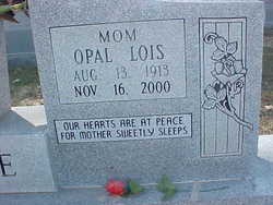
| Birth | : | 13 Aug 1913 Arkansas, USA |
| Death | : | 16 Nov 2000 Niles, Berrien County, Michigan, USA |
| Burial | : | All Saints Churchyard, Biddenden, Ashford Borough, England |
| Coordinate | : | 51.1150740, 0.6403990 |
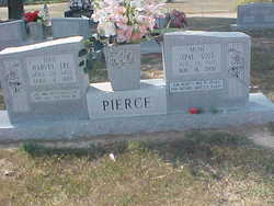
| Inscription | : | Married Feb 14, 1930/Our Hearts Are At Peace For Mother Sweetly Sleeps |
| Description | : | Mrs. Opal Lois Pierce, 87, of 2635 Korn Street of Niles, Mich., died Thursday at her home. She was born in Ozark and was of the Methodist faith. She was preceded in death by her husband, Harvey Lee Pierce, one son and three brothers. Survivors include two sons, W.J. Pierce of Jerusalem and Walter Pierce of Niles, Mich.; one daughter, Betty Van Lue, of Niles, Mich.; two brothers, John Andrews of Cherry Valley and Fred Andrews of Wynne; one sister, Edna Allen of Vanndale; 12 grandchildren; 21 great-grandchildren; and one great-great-grandchild. Funeral services will... Read More |
frequently asked questions (FAQ):
-
Where is Opal Lois Andrews Pierce's memorial?
Opal Lois Andrews Pierce's memorial is located at: All Saints Churchyard, Biddenden, Ashford Borough, England.
-
When did Opal Lois Andrews Pierce death?
Opal Lois Andrews Pierce death on 16 Nov 2000 in Niles, Berrien County, Michigan, USA
-
Where are the coordinates of the Opal Lois Andrews Pierce's memorial?
Latitude: 51.1150740
Longitude: 0.6403990
Family Members:
Parent
Spouse
Siblings
Children
Flowers:
Nearby Cemetories:
1. All Saints Churchyard
Biddenden, Ashford Borough, England
Coordinate: 51.1150740, 0.6403990
2. Ebeneezer Chapel
Biddenden, Ashford Borough, England
Coordinate: 51.1383320, 0.6416030
3. St. Mary's Churchyard
Frittenden, Tunbridge Wells Borough, England
Coordinate: 51.1391190, 0.5904720
4. St. Michael and All Angels Churchyard
Tenterden, Ashford Borough, England
Coordinate: 51.0867424, 0.6894140
5. Frittenden Burial Gound
Frittenden, Tunbridge Wells Borough, England
Coordinate: 51.1428480, 0.5870820
6. St. Michael the Archangel Churchyard
Smarden, Ashford Borough, England
Coordinate: 51.1490030, 0.6861940
7. St. Mary the Virgin Churchyard
High Halden, Ashford Borough, England
Coordinate: 51.1028950, 0.7148620
8. Sissinghurst Cemetery
Sissinghurst, Tunbridge Wells Borough, England
Coordinate: 51.1095310, 0.5629240
9. Tenterden Cemetery
Tenterden, Ashford Borough, England
Coordinate: 51.0676820, 0.6737140
10. Headcorn Baptist Churchyard
Headcorn, Maidstone Borough, England
Coordinate: 51.1674156, 0.6247670
11. Headcorn Parish Burial Ground
Headcorn, Maidstone Borough, England
Coordinate: 51.1671257, 0.6204750
12. Unitarian Old Meeting House
Tenterden, Ashford Borough, England
Coordinate: 51.0717468, 0.6906880
13. Headcorn Methodist Churchyard
Headcorn, Maidstone Borough, England
Coordinate: 51.1674940, 0.6205670
14. Headcorn War Memorial
Headcorn, Maidstone Borough, England
Coordinate: 51.1677480, 0.6212560
15. St. Peter and St. Paul Churchyard
Headcorn, Maidstone Borough, England
Coordinate: 51.1678543, 0.6203760
16. Station Road Extension
Tenterden, Ashford Borough, England
Coordinate: 51.0686640, 0.6852830
17. St. Mildred's Churchyard
Tenterden, Ashford Borough, England
Coordinate: 51.0686264, 0.6870960
18. Cranbrook Cemetery
Cranbrook, Tunbridge Wells Borough, England
Coordinate: 51.0962250, 0.5541360
19. St. George Parish Churchyard
Benenden, Tunbridge Wells Borough, England
Coordinate: 51.0648720, 0.5794570
20. St. Mary the Virgin Churchyard
Rolvenden, Ashford Borough, England
Coordinate: 51.0506590, 0.6310280
21. St David's Bridge Strict Baptist Chapel
Cranbrook, Tunbridge Wells Borough, England
Coordinate: 51.0953430, 0.5378980
22. St Dunstan's Churchyard
Cranbrook, Tunbridge Wells Borough, England
Coordinate: 51.0973030, 0.5363690
23. All Saints Church
Staplehurst, Maidstone Borough, England
Coordinate: 51.1582160, 0.5527170
24. St. Margaret's Churchyard
Bethersden, Ashford Borough, England
Coordinate: 51.1291440, 0.7538760

