
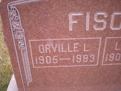

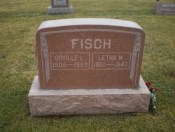
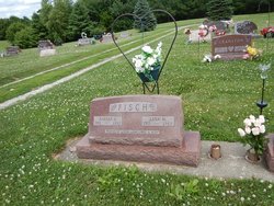
Orville Lee Fisch
| Birth | : | 15 Oct 1905 Poweshiek County, Iowa, USA |
| Death | : | 1 Apr 1983 Montezuma, Poweshiek County, Iowa, USA |
| Burial | : | Fairview Cemetery, Smith Center, Smith County, USA |
| Coordinate | : | 39.7966995, -98.7881012 |
| Description | : | Orville L. Fisch, 77, of Deep River died Friday at the Senior Home in Montezuma. He was born Oct. 15, 1905, in Poweshiek County, the son of Henry and Margaret Armstrong Fisch. He attended the Deep River rural school and farmed until 1945 until he moved into Deep River where he sold feed and later was a independent hog buyer. On July 31, 1956, he married Dorothy Morgan at Humeston. He was a member of the Moose Lodge and Eagles Lodge, both of Oskaloosa. He was preceded in death by his parents and one brother. Survivors include his wife of Deep River;... Read More |
frequently asked questions (FAQ):
-
Where is Orville Lee Fisch's memorial?
Orville Lee Fisch's memorial is located at: Fairview Cemetery, Smith Center, Smith County, USA.
-
When did Orville Lee Fisch death?
Orville Lee Fisch death on 1 Apr 1983 in Montezuma, Poweshiek County, Iowa, USA
-
Where are the coordinates of the Orville Lee Fisch's memorial?
Latitude: 39.7966995
Longitude: -98.7881012
Family Members:
Parent

Spouse
Siblings
Flowers:


Nearby Cemetories:
1. Fairview Cemetery
Smith Center, Smith County, USA
Coordinate: 39.7966995, -98.7881012
2. Pleasant View Cemetery
Athol, Smith County, USA
Coordinate: 39.7859000, -98.8982000
3. Meade Cemetery
Reamsville, Smith County, USA
Coordinate: 39.8680992, -98.8839035
4. Saint John Lutheran Cemetery
Athol, Smith County, USA
Coordinate: 39.7269900, -98.8971600
5. Zion Cemetery
Athol, Smith County, USA
Coordinate: 39.8434100, -98.9171700
6. William Nelson Gravesite
Athol, Smith County, USA
Coordinate: 39.8866080, -98.8708130
7. Christ Cemetery
Gaylord, Smith County, USA
Coordinate: 39.6988100, -98.8556700
8. Custer Cemetery
Bellaire, Smith County, USA
Coordinate: 39.7350115, -98.6545141
9. Spring Vale Cemetery
Washington Township, Smith County, USA
Coordinate: 39.9154700, -98.7424900
10. Cedar Hill Cemetery
Cora, Smith County, USA
Coordinate: 39.8863200, -98.6550000
11. Crystal Plains Cemetery
Smith Center, Smith County, USA
Coordinate: 39.6909714, -98.6730270
12. Oak Hill Cemetery
Lebanon, Smith County, USA
Coordinate: 39.8437010, -98.6186200
13. Gaylord Cemetery
Gaylord, Smith County, USA
Coordinate: 39.6598300, -98.8416700
14. Parse Homestead Cemetery
Bellaire, Smith County, USA
Coordinate: 39.7269800, -98.6245300
15. Price Cemetery
Oak Township, Smith County, USA
Coordinate: 39.7986860, -98.5993060
16. Eminence Cemetery
Thornburg, Smith County, USA
Coordinate: 39.9432983, -98.8005981
17. Reamsville Methodist Church Cemetery
Reamsville, Smith County, USA
Coordinate: 39.9299500, -98.8693970
18. Reamsville Cemetery
Reamsville, Smith County, USA
Coordinate: 39.9441500, -98.8593500
19. Bell Cemetery
Smith Center, Smith County, USA
Coordinate: 39.6477700, -98.7102200
20. Cedar Cemetery
Cedar, Smith County, USA
Coordinate: 39.6685982, -98.9310989
21. Old Harlan Cemetery
Harlan, Smith County, USA
Coordinate: 39.6153520, -98.7632390
22. Pleasant Hill Cemetery
Reamsville, Smith County, USA
Coordinate: 39.9510994, -98.9175034
23. Sweet Home Cemetery
Lebanon, Smith County, USA
Coordinate: 39.7854830, -98.5465380
24. Womer Cemetery
Womer, Smith County, USA
Coordinate: 39.9736400, -98.7110800