
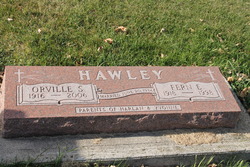

Orville Sargent Hawley
| Birth | : | 10 Feb 1916 |
| Death | : | 7 Nov 2006 |
| Burial | : | St Thomas and the Holy Rood Churchyard, Melling, Metropolitan Borough of Sefton, England |
| Coordinate | : | 53.4954510, -2.9227850 |
| Description | : | Orville S. Hawley, age 90, of Laurens, passed away Tuesday, Nov. 7, 2006, at the Spencer Municipal Hospital in Spencer, Iowa. Graveside services are 11 a.m. Tuesday, Nov. 14, 2006, at the Laurens Cemetery near Laurens, Iowa, with the Rev. Larry McAlpine officiating. There is no visitation. The Smith-Loterbour-Powers Funeral Home in Laurens is handling arrangements. Orville Sargent Hawley was born Feb. 11, 1916, at Laurens, Iowa. He graduated from Ware High School in 1933. On June 20, 1936, Orville married Fern Stover at LuVerne. The couple settled near Laurens where they farmed. In 1961, they moved to California where they operated... Read More |
frequently asked questions (FAQ):
-
Where is Orville Sargent Hawley's memorial?
Orville Sargent Hawley's memorial is located at: St Thomas and the Holy Rood Churchyard, Melling, Metropolitan Borough of Sefton, England.
-
When did Orville Sargent Hawley death?
Orville Sargent Hawley death on 7 Nov 2006 in
-
Where are the coordinates of the Orville Sargent Hawley's memorial?
Latitude: 53.4954510
Longitude: -2.9227850
Family Members:
Parent
Spouse

Siblings

Flowers:


Nearby Cemetories:
1. St Thomas and the Holy Rood Churchyard
Melling, Metropolitan Borough of Sefton, England
Coordinate: 53.4954510, -2.9227850
2. Melling Churchyard
Melling, Metropolitan Borough of Sefton, England
Coordinate: 53.4953370, -2.9228780
3. St. Andrew Churchyard
Maghull, Metropolitan Borough of Sefton, England
Coordinate: 53.5104770, -2.9428820
4. St. Chad Churchyard
Kirkby, Metropolitan Borough of Knowsley, England
Coordinate: 53.4842890, -2.8930700
5. Aintree Racecourse Grounds
Aintree Village, Metropolitan Borough of Sefton, England
Coordinate: 53.4733880, -2.9549700
6. Sefton Parish Churchyard
Sefton, Metropolitan Borough of Sefton, England
Coordinate: 53.5044060, -2.9712190
7. Kirkdale Cemetery
Liverpool, Metropolitan Borough of Liverpool, England
Coordinate: 53.4672530, -2.9479800
8. St Swithins Churchyard
Liverpool, Metropolitan Borough of Liverpool, England
Coordinate: 53.4585631, -2.9012280
9. Everton Cemetery
Everton, Metropolitan Borough of Liverpool, England
Coordinate: 53.4555430, -2.9442480
10. Long Lane Jewish Cemetery
Liverpool, Metropolitan Borough of Liverpool, England
Coordinate: 53.4550140, -2.9420480
11. Thornton Garden of Rest and Crematorium
Thornton, Metropolitan Borough of Sefton, England
Coordinate: 53.5001850, -2.9951960
12. Ford Cemetery
Ford, Metropolitan Borough of Sefton, England
Coordinate: 53.4824040, -2.9925980
13. West Derby Cemetery
West Derby, Metropolitan Borough of Liverpool, England
Coordinate: 53.4513790, -2.9154630
14. West Derby Jewish Cemetery
Liverpool, Metropolitan Borough of Liverpool, England
Coordinate: 53.4504986, -2.9137393
15. Saint Michael's Churchyard
Aughton, West Lancashire District, England
Coordinate: 53.5419170, -2.9197240
16. Bootle Cemetery
Bootle, Metropolitan Borough of Sefton, England
Coordinate: 53.4627680, -2.9787450
17. St Catherine Churchyard
Lydiate, Metropolitan Borough of Sefton, England
Coordinate: 53.5368000, -2.9612660
18. Walton Park Cemetery
Walton, Metropolitan Borough of Liverpool, England
Coordinate: 53.4564370, -2.9695960
19. Rice Lane Jewish Cemetery
Walton, Metropolitan Borough of Liverpool, England
Coordinate: 53.4521700, -2.9590600
20. Friends Burial Ground
Bickerstaffe, West Lancashire District, England
Coordinate: 53.5347720, -2.8748780
21. Our Lady's Roman Catholic Churchyard
Lydiate, Metropolitan Borough of Sefton, England
Coordinate: 53.5396850, -2.9599940
22. St Thomas Churchyard
Lydiate, Metropolitan Borough of Sefton, England
Coordinate: 53.5443480, -2.9621640
23. St Mary the Virgin Churchyard
Walton, Metropolitan Borough of Liverpool, England
Coordinate: 53.4464930, -2.9673330
24. St. Mary's Churchyard
Knowsley, Metropolitan Borough of Knowsley, England
Coordinate: 53.4561960, -2.8528580