
Paul Dale “PD” Dickson
| Birth | : | 22 Oct 1934 Clayton County, Iowa, USA |
| Death | : | 12 Jun 2021 Edgewood, Delaware County, Iowa, USA |
| Burial | : | Saint Johns Cemetery, Jefferson Township, Clayton County, USA |
| Coordinate | : | 42.7497000, -91.1133000 |
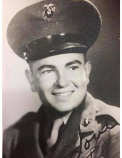
| Description | : | Paul Dale "PD" Dickson, age 86, of Guttenberg, IA, died Saturday, June 12, 2021, at the Edgewood Convalescent Home. He was born on October 22, 1934, the son of Francis and Hilda (Friedlein) Dickson. PD received his education locally and graduated from the Guttenberg High School. PD enlisted in the United States Marine Corp where he served his country proudly from Aug 3, 1953 till his honorable discharge in Aug 2, 1956. On August 25, 1956, PD was united in... Read More |
frequently asked questions (FAQ):
-
Where is Paul Dale “PD” Dickson's memorial?
Paul Dale “PD” Dickson's memorial is located at: Saint Johns Cemetery, Jefferson Township, Clayton County, USA.
-
When did Paul Dale “PD” Dickson death?
Paul Dale “PD” Dickson death on 12 Jun 2021 in Edgewood, Delaware County, Iowa, USA
-
Where are the coordinates of the Paul Dale “PD” Dickson's memorial?
Latitude: 42.7497000
Longitude: -91.1133000
Family Members:
Parent

Spouse

Flowers:


Nearby Cemetories:
1. Saint Johns Cemetery
Jefferson Township, Clayton County, USA
Coordinate: 42.7497000, -91.1133000
2. Guttenberg Cemetery
Guttenberg, Clayton County, USA
Coordinate: 42.7691994, -91.1035995
3. Saint Marys Cemetery
Guttenberg, Clayton County, USA
Coordinate: 42.7691994, -91.1352997
4. Mount Olivet Cemetery
Guttenberg, Clayton County, USA
Coordinate: 42.7764840, -91.1083560
5. Bierer Cemetery
Millville, Clayton County, USA
Coordinate: 42.7230500, -91.0925166
6. Redman Cemetery
Millville, Clayton County, USA
Coordinate: 42.7166755, -91.0852901
7. Friedlein Cemetery
Millville, Clayton County, USA
Coordinate: 42.7080994, -91.1108017
8. Lewis Cemetery
Osterdock, Clayton County, USA
Coordinate: 42.7416000, -91.1834000
9. Storck Cemetery
Guttenberg, Clayton County, USA
Coordinate: 42.7694335, -91.1834638
10. Bethel Cemetery
Osterdock, Clayton County, USA
Coordinate: 42.7041702, -91.1688919
11. Saint Paula Cemetery
Osterdock, Clayton County, USA
Coordinate: 42.7635994, -91.1992035
12. Graham Cemetery
Millville, Clayton County, USA
Coordinate: 42.6833172, -91.1195685
13. Old Saint Marys Cemetery
Glen Haven, Grant County, USA
Coordinate: 42.8078100, -91.0675330
14. Charlotte Cemetery
Glen Haven, Grant County, USA
Coordinate: 42.7933006, -91.0381012
15. Borcherding Cemetery
Jefferson Township, Clayton County, USA
Coordinate: 42.8182983, -91.1414032
16. Goshen Cemetery
Millville, Clayton County, USA
Coordinate: 42.6905594, -91.0544434
17. Saint Michael Cemetery
Clayton County, USA
Coordinate: 42.8055992, -91.1802979
18. Bolsinger Cemetery
Mallory Township, Clayton County, USA
Coordinate: 42.6776340, -91.1424090
19. Duncan Cemetery
Glen Haven, Grant County, USA
Coordinate: 42.8325540, -91.0725940
20. Pioneer Rock Cemetery
Ceres, Clayton County, USA
Coordinate: 42.8230591, -91.1863937
21. Ramsey Cemetery
North Andover, Grant County, USA
Coordinate: 42.7817001, -90.9972000
22. Gockel Cemetery
Glen Haven, Grant County, USA
Coordinate: 42.8224983, -91.0385971
23. Noggle Cemetery
Clayton County, USA
Coordinate: 42.6666580, -91.1654100
24. McClelland Cemetery
Garnavillo, Clayton County, USA
Coordinate: 42.8249879, -91.2084641