
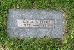
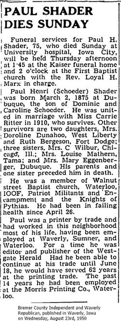
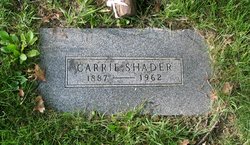
Paul Henri Shader
| Birth | : | 2 Mar 1875 Dubuque, Dubuque County, Iowa, USA |
| Death | : | 20 Aug 1950 Iowa City, Johnson County, Iowa, USA |
| Burial | : | Oakwood Cemetery, Parsons, Labette County, USA |
| Coordinate | : | 37.3375500, -95.2402800 |
| Plot | : | Section E, Lot 38, Grave 2 |
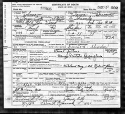
| Description | : | Paul Shader's father's name was spelled Schoeder No grave for father. Since this is different from the ordinary situation I want you to know that I uploaded the death record for Paul Shader to his memorial because it has the correct spelling for Paul's father's surname. His first name was Dominick. Many descendants of Paul, named his father as Dominick Shader based on Paul's marriage record. contributor Mary Quirk-Thompson Iowa, County Marriages, 1838-1934 father: Dominique Shader mother: Caroline Heller marriage: 21 May 1898 Sumner, Bremer, Iowa spouse: Minnie Formaker parents: Godfrey Formaker (Doormaker), Wilhelmine Kutchewnoter marriage: 24... Read More |
frequently asked questions (FAQ):
-
Where is Paul Henri Shader's memorial?
Paul Henri Shader's memorial is located at: Oakwood Cemetery, Parsons, Labette County, USA.
-
When did Paul Henri Shader death?
Paul Henri Shader death on 20 Aug 1950 in Iowa City, Johnson County, Iowa, USA
-
Where are the coordinates of the Paul Henri Shader's memorial?
Latitude: 37.3375500
Longitude: -95.2402800
Family Members:
Spouse
Children
Flowers:


Nearby Cemetories:
1. Oakwood Cemetery
Parsons, Labette County, USA
Coordinate: 37.3375500, -95.2402800
2. Lucken Cemetery
Parsons, Labette County, USA
Coordinate: 37.3547870, -95.2854960
3. Pefley Cemetery
Parsons, Labette County, USA
Coordinate: 37.3564900, -95.2856000
4. Parsons State Hospital Cemetery
Parsons, Labette County, USA
Coordinate: 37.3571060, -95.2856310
5. Calvary Cemetery
Parsons, Labette County, USA
Coordinate: 37.3578100, -95.2855000
6. Memorial Lawn Cemetery
Parsons, Labette County, USA
Coordinate: 37.3013992, -95.2833023
7. Spring Hill Cemetery
Parsons, Labette County, USA
Coordinate: 37.2882000, -95.2497500
8. Mount Olivet Roman Catholic Cemetery
Parsons, Labette County, USA
Coordinate: 37.2998500, -95.2857500
9. Franklin Cemetery
Montana, Labette County, USA
Coordinate: 37.3182983, -95.1746979
10. East Bethany Cemetery
Neosho County, USA
Coordinate: 37.3983002, -95.2692032
11. West Bethany Cemetery
Neosho County, USA
Coordinate: 37.3983002, -95.2699966
12. Center Cemetery
Labette County, USA
Coordinate: 37.3396730, -95.1576630
13. Evergreen Cemetery
Neosho County, USA
Coordinate: 37.4008446, -95.2063217
14. Oak Grove Cemetery
Neosho County, USA
Coordinate: 37.3968925, -95.1700974
15. Fairview Cemetery
Parsons, Labette County, USA
Coordinate: 37.2963700, -95.1408800
16. Old Oak Grove Cemetery
Neosho County, USA
Coordinate: 37.4050751, -95.1635742
17. Ladore Cemetery
Ladore Township, Neosho County, USA
Coordinate: 37.4059000, -95.3169500
18. South Mound Cemetery
South Mound, Neosho County, USA
Coordinate: 37.4349800, -95.2245400
19. Brown Cemetery
Neosho County, USA
Coordinate: 37.4244003, -95.1725006
20. Labette Cemetery
Labette, Labette County, USA
Coordinate: 37.2447014, -95.1772003
21. Valley Cemetery
Galesburg, Neosho County, USA
Coordinate: 37.3986500, -95.3522400
22. Wilsonton Cemetery
Parsons, Labette County, USA
Coordinate: 37.2597700, -95.3397800
23. Richland Cemetery
Neosho County, USA
Coordinate: 37.4024162, -95.1253357
24. Montana Cemetery
Montana, Labette County, USA
Coordinate: 37.2661157, -95.1315282