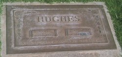
Paul Lester Hughes
| Birth | : | 27 Dec 1907 Caney, Montgomery County, Kansas, USA |
| Death | : | 30 Jan 1988 San Diego, San Diego County, California, USA |
| Burial | : | Phil Campbell Cemetery, Phil Campbell, Franklin County, USA |
| Coordinate | : | 34.3488998, -87.7058029 |
| Inscription | : | IN THE GARDEN OF MEMORIES WE MEET EACH DAY |
| Description | : | Paul Lester Hughes, a three-year San Marcos resident, died January 30 at Palomar Hospital in Escondido. He was 80. Born December 27, 1907 in Caney, Kansas, he lived in San Diego County for 25 years. He was a carpenter and member of the Carpenters Union Local No. 151 for 50 years in Seattle before retiring in 1963. He enjoyed game bird hunting and fishing. He is survived by his wife of 55 years, Opal; daughters, Beverly Fishback of Etiwanda California, Dolores Craig of Bothell, Washington, and Mary Schetne of San Marcos; 13 grandchildren; and 12 great grandchildren. |
frequently asked questions (FAQ):
-
Where is Paul Lester Hughes's memorial?
Paul Lester Hughes's memorial is located at: Phil Campbell Cemetery, Phil Campbell, Franklin County, USA.
-
When did Paul Lester Hughes death?
Paul Lester Hughes death on 30 Jan 1988 in San Diego, San Diego County, California, USA
-
Where are the coordinates of the Paul Lester Hughes's memorial?
Latitude: 34.3488998
Longitude: -87.7058029
Family Members:
Parent
Siblings
Flowers:
Nearby Cemetories:
1. Phil Campbell Cemetery
Phil Campbell, Franklin County, USA
Coordinate: 34.3488998, -87.7058029
2. Mars Hill Cemetery
Phil Campbell, Franklin County, USA
Coordinate: 34.3391991, -87.6968994
3. Mountain View Cemetery
Phil Campbell, Franklin County, USA
Coordinate: 34.3394000, -87.6847000
4. Dooley Cemetery
Franklin County, USA
Coordinate: 34.3746986, -87.6896973
5. Center Point Cemetery
Franklin County, USA
Coordinate: 34.3196983, -87.6889038
6. Shady Grove Cemetery #1
Phil Campbell, Franklin County, USA
Coordinate: 34.3175011, -87.7305984
7. Liberty Hill Cemetery
Liberty Hill, Franklin County, USA
Coordinate: 34.3438988, -87.7668991
8. Swinney Family Cemetery
Liberty Hill, Franklin County, USA
Coordinate: 34.3421402, -87.7679214
9. Wendy Hollow Cemetery
Liberty Hill, Franklin County, USA
Coordinate: 34.3410680, -87.7680530
10. Bethel Cemetery
Franklin County, USA
Coordinate: 34.3167000, -87.6519012
11. Shady Grove Cemetery #3
Phil Campbell, Franklin County, USA
Coordinate: 34.3507000, -87.7761000
12. Bear Creek #1 Baptist Church Cemetery
Bear Creek, Marion County, USA
Coordinate: 34.2900009, -87.6956024
13. Arnold Cemetery
Bear Creek, Marion County, USA
Coordinate: 34.2910995, -87.6735992
14. Bear Creek Cemetery
Bear Creek, Marion County, USA
Coordinate: 34.2832985, -87.6980972
15. Antioch Baptist Church Cemetery
Hackleburg, Marion County, USA
Coordinate: 34.2956009, -87.7542038
16. Chestnut Ridge Cemetery
Franklin County, USA
Coordinate: 34.3358002, -87.6247025
17. Old Zion Factory Cemetery
Allens Factory, Marion County, USA
Coordinate: 34.2816200, -87.7219800
18. John Bull Cemetery
Marion County, USA
Coordinate: 34.2789001, -87.7210999
19. Fortner Cemetery
Marion County, USA
Coordinate: 34.2994003, -87.7692032
20. Brock Cemetery
Nix Mill, Franklin County, USA
Coordinate: 34.3521996, -87.7977982
21. Blue Springs Cemetery
Phil Campbell, Franklin County, USA
Coordinate: 34.4132996, -87.6564026
22. Hines Memorial Baptist Church Cemetery
Bear Creek, Marion County, USA
Coordinate: 34.2713465, -87.7213735
23. Shiloh Methodist Church Cemetery
Haleyville, Winston County, USA
Coordinate: 34.2924995, -87.6333008
24. Edgar Cemetery
Franklin County, USA
Coordinate: 34.3507996, -87.8110962


