
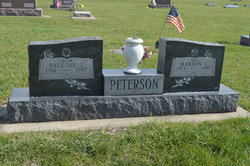
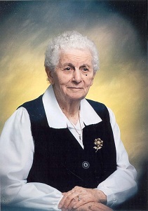
Pauline Lavera Shoberg Peterson
| Birth | : | 3 Jan 1916 Stratford, Hamilton County, Iowa, USA |
| Death | : | 7 Aug 1997 Stratford, Hamilton County, Iowa, USA |
| Burial | : | South Marion Cemetery, Stratford, Hamilton County, USA |
| Coordinate | : | 42.2327995, -93.8735962 |
| Description | : | Stratford Courier August 13, 1997 Pauline L. Peterson, 81, formerly of 831 Dryden Street, Stratford, Iowa, passed away at the Stratford Care Center in Stratford on Thursday morning, August 7, 1997, due to congestive heart failure. She had been a resident at the Stratford Care Center since September of 1992. She was born on January 3, 1016 in Stratford, Iowa, the daughter of J.W. and Edith (Hagstrom) Shoberg. On August 13, 1933 she married Marvin LuVerne Peterson at the Methodist Church in Des Moines, Iowa. Pauline attended country school and Stratford public school. She was a... Read More |
frequently asked questions (FAQ):
-
Where is Pauline Lavera Shoberg Peterson's memorial?
Pauline Lavera Shoberg Peterson's memorial is located at: South Marion Cemetery, Stratford, Hamilton County, USA.
-
When did Pauline Lavera Shoberg Peterson death?
Pauline Lavera Shoberg Peterson death on 7 Aug 1997 in Stratford, Hamilton County, Iowa, USA
-
Where are the coordinates of the Pauline Lavera Shoberg Peterson's memorial?
Latitude: 42.2327995
Longitude: -93.8735962
Family Members:
Parent

Spouse

Siblings
Children


Flowers:


Nearby Cemetories:
1. South Marion Cemetery
Stratford, Hamilton County, USA
Coordinate: 42.2327995, -93.8735962
2. Oakwood Cemetery
Stratford, Hamilton County, USA
Coordinate: 42.2942009, -93.9182968
3. Mineral Ridge Cemetery
Ridgeport, Boone County, USA
Coordinate: 42.1749992, -93.9266968
4. Hooks Point Cemetery
Hamilton County, USA
Coordinate: 42.2944530, -93.9199090
5. Hardin Township Cemetery
Hardin Township, Webster County, USA
Coordinate: 42.2411003, -93.9708023
6. Saint Paul Lutheran Cemetery
Boone, Boone County, USA
Coordinate: 42.1700000, -93.8070000
7. Boone County Poor Farm Cemetery
Boone County, USA
Coordinate: 42.1591100, -93.9159000
8. White Cemetery
Boone County, USA
Coordinate: 42.1777992, -93.9636002
9. Lake Center Cemetery
Stanhope, Hamilton County, USA
Coordinate: 42.2482986, -93.7568970
10. Leininger Cemetery
Boone County, USA
Coordinate: 42.1492004, -93.8356018
11. Lawn Hill Cemetery
Stanhope, Hamilton County, USA
Coordinate: 42.2677994, -93.7611008
12. Nesse Cemetery
Hamilton County, USA
Coordinate: 42.3250008, -93.8933029
13. Neese Cemetery
Homer, Hamilton County, USA
Coordinate: 42.3250000, -93.8935000
14. Linn Cemetery
Pilot Mound, Boone County, USA
Coordinate: 42.2045330, -93.9970230
15. Vegors Cemetery
Webster County, USA
Coordinate: 42.3177986, -93.9421997
16. Mackey Cemetery
Boone County, USA
Coordinate: 42.1675000, -93.7565000
17. Runyan Cemetery
Pilot Mound, Boone County, USA
Coordinate: 42.1749992, -94.0015030
18. Saint Pauls Church Cemetery
Jewell, Hamilton County, USA
Coordinate: 42.2490100, -93.7173400
19. Schlicht Cemetery
Fraser, Boone County, USA
Coordinate: 42.1444200, -93.9780100
20. Bass Cemetery
Dayton, Webster County, USA
Coordinate: 42.2966995, -94.0149994
21. Saratoga Cemetery
Stanhope, Hamilton County, USA
Coordinate: 42.3539009, -93.8167038
22. Pilot Mound Cemetery
Pilot Mound, Boone County, USA
Coordinate: 42.1636200, -94.0282600
23. Ellsworth Clear Lake Cemetery
Randall, Hamilton County, USA
Coordinate: 42.2268930, -93.6926200
24. Bass Point Cemetery
Boone, Boone County, USA
Coordinate: 42.0992012, -93.8957977