
| Birth | : | 16 Apr 1933 Clarks, Merrick County, Nebraska, USA |
| Death | : | 14 Jan 2011 Central City, Merrick County, Nebraska, USA |
| Burial | : | McCroskie Creek Baptist Church Cemetery, Carroll County, USA |
| Coordinate | : | 39.3840179, -93.6199951 |
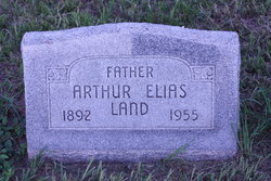
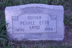
| Description | : | P. "Illene" Harlow, 77, of Central City died Friday, Jan. 14, 2011, at Litzenberg Memorial Long Term Care in Central City. Illene was born on April 16, 1933, in Clarks to Arthur E. and Pearle E. (Anderson) Land. Illene was united in marriage to Frank Harlow on Dec.30, 1950 in Central City. Survivors are: husband; sons and daughters-in-law, Alan and Deborah Harlow of Lincoln, Terry and Linda Harlow of McCool Junction, Tim and Nancy Harlow of Central City, and Tom Harlow of Hastings; two daughters and sons-in-law, Kathleen and Dwain Olsen of Central City and Christine and... Read More |
frequently asked questions (FAQ):
-
Where is Pearle Illene Land Harlow's memorial?
Pearle Illene Land Harlow's memorial is located at: McCroskie Creek Baptist Church Cemetery, Carroll County, USA.
-
When did Pearle Illene Land Harlow death?
Pearle Illene Land Harlow death on 14 Jan 2011 in Central City, Merrick County, Nebraska, USA
-
Where are the coordinates of the Pearle Illene Land Harlow's memorial?
Latitude: 39.3840179
Longitude: -93.6199951
Family Members:
Parent
Spouse

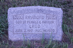
Siblings
Flowers:


Nearby Cemetories:
1. McCroskie Creek Baptist Church Cemetery
Carroll County, USA
Coordinate: 39.3840179, -93.6199951
2. Unnamed Cemetery #47
Carroll County, USA
Coordinate: 39.3558998, -93.6673965
3. German Methodist Cemetery
Norborne, Carroll County, USA
Coordinate: 39.3428001, -93.6500015
4. Trotter Cemetery
Carrollton, Carroll County, USA
Coordinate: 39.3793983, -93.5569000
5. Clowdis Cemetery
Carroll County, USA
Coordinate: 39.3386700, -93.6573500
6. Powell Cemetery
Carroll County, USA
Coordinate: 39.4094000, -93.5544000
7. Antioch Cemetery
Norborne, Carroll County, USA
Coordinate: 39.4083519, -93.7010498
8. Campbell Cemetery
Carroll County, USA
Coordinate: 39.3908997, -93.5307999
9. Kasriek Cemetery
Carroll County, USA
Coordinate: 39.4556999, -93.5977020
10. Unnamed Cemetery #51
Carroll County, USA
Coordinate: 39.4334984, -93.5492020
11. Trinity Lutheran Cemetery
Norborne, Carroll County, USA
Coordinate: 39.3293991, -93.6844025
12. Stempel Cemetery
Norborne, Carroll County, USA
Coordinate: 39.3270780, -93.6829730
13. Unnamed Cemetery #94
Carroll County, USA
Coordinate: 39.3541985, -93.5298004
14. Street Cemetery
Bogard, Carroll County, USA
Coordinate: 39.4606018, -93.5969009
15. Providence Cemetery
Norborne, Carroll County, USA
Coordinate: 39.3511009, -93.7230988
16. Carroll Memory Gardens
Carrollton, Carroll County, USA
Coordinate: 39.3729430, -93.5092060
17. Oak Hill Cemetery
Carrollton, Carroll County, USA
Coordinate: 39.3527985, -93.5111008
18. Union Baptist Church Cemetery
Roads, Carroll County, USA
Coordinate: 39.4486008, -93.7021027
19. Mount Zion Cemetery
Bogard, Carroll County, USA
Coordinate: 39.4352989, -93.5214005
20. Sacred Heart Cemetery
Norborne, Carroll County, USA
Coordinate: 39.2914009, -93.6247025
21. Ebenezer Cemetery
Bogard, Carroll County, USA
Coordinate: 39.4692001, -93.5691986
22. Smith Cemetery
Carroll County, USA
Coordinate: 39.4813995, -93.6205978
23. Unnamed Cemetery #85
Carroll County, USA
Coordinate: 39.2863998, -93.6071014
24. Unnamed Cemetery #26
Carroll County, USA
Coordinate: 39.4808006, -93.5985031