
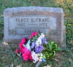
Percy Edward Craig
| Birth | : | 16 Aug 1887 Davis City, Decatur County, Iowa, USA |
| Death | : | 26 Oct 1972 Leon, Decatur County, Iowa, USA |
| Burial | : | St Peter's Churchyard, Heswall, Metropolitan Borough of Wirral, England |
| Coordinate | : | 53.3227400, -3.1036400 |
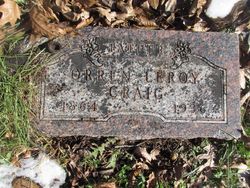
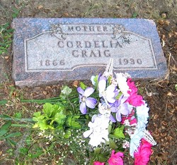
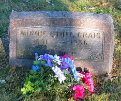
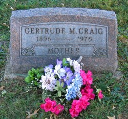
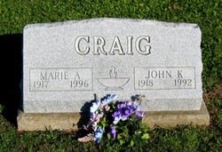
| Description | : | Son of Orren Leroy "Lee" Craig (1864-1936) and Cordelia "Del" (Wheeler) Craig (1866-1930) both interred Old Davis City Cemetery; married 1st 1908 Minnie Ethel Bennett (1891-1936) and father of Cletus, Emmett, Basil, Edwin O'Neil (KIA WWII), John Kenneth, Willard, Roe, Berniece, and Helen; married 2nd 1936 Gertrude Margaret (Johnson) Kaestner |
frequently asked questions (FAQ):
-
Where is Percy Edward Craig's memorial?
Percy Edward Craig's memorial is located at: St Peter's Churchyard, Heswall, Metropolitan Borough of Wirral, England.
-
When did Percy Edward Craig death?
Percy Edward Craig death on 26 Oct 1972 in Leon, Decatur County, Iowa, USA
-
Where are the coordinates of the Percy Edward Craig's memorial?
Latitude: 53.3227400
Longitude: -3.1036400
Family Members:
Parent
Spouse
Siblings

Children


Flowers:


Nearby Cemetories:
1. St Peter's Churchyard
Heswall, Metropolitan Borough of Wirral, England
Coordinate: 53.3227400, -3.1036400
2. Heswall Cemetery
Heswall, Metropolitan Borough of Wirral, England
Coordinate: 53.3400420, -3.1102790
3. Barnston Cemetery
Barnston, Metropolitan Borough of Wirral, England
Coordinate: 53.3408590, -3.0820730
4. St Bartholomew's Churchyard
Thurstaston, Metropolitan Borough of Wirral, England
Coordinate: 53.3485750, -3.1320070
5. All Saints Churchyard
Thornton Hough, Metropolitan Borough of Wirral, England
Coordinate: 53.3203500, -3.0444780
6. Neston Cemetery
Neston, Cheshire West and Chester Unitary Authority, England
Coordinate: 53.2943100, -3.0571400
7. St Mary and St Helen Neston
Neston, Cheshire West and Chester Unitary Authority, England
Coordinate: 53.2892600, -3.0640600
8. Landican Cemetery and Crematorium
Woodchurch, Metropolitan Borough of Wirral, England
Coordinate: 53.3654000, -3.0887510
9. Saint Winefride Churchyard
Little Neston, Cheshire West and Chester Unitary Authority, England
Coordinate: 53.2849200, -3.0592100
10. Holy Cross Churchyard
Woodchurch, Metropolitan Borough of Wirral, England
Coordinate: 53.3731900, -3.0899400
11. Frankby Cemetery
Frankby, Metropolitan Borough of Wirral, England
Coordinate: 53.3715920, -3.1399600
12. St. John the Divine
Frankby, Metropolitan Borough of Wirral, England
Coordinate: 53.3744200, -3.1330200
13. Christ Church
Bebington, Metropolitan Borough of Wirral, England
Coordinate: 53.3584460, -3.0254810
14. Salacre Lane Cemetery
Upton, Metropolitan Borough of Wirral, England
Coordinate: 53.3824050, -3.0919920
15. Saint Mary's Churchyard
Upton, Metropolitan Borough of Wirral, England
Coordinate: 53.3847010, -3.0961600
16. St Bridget Churchyard
West Kirby, Metropolitan Borough of Wirral, England
Coordinate: 53.3687130, -3.1764480
17. Bebington Cemetery
Bebington, Metropolitan Borough of Wirral, England
Coordinate: 53.3588030, -3.0165370
18. Christ Church Churchyard
Willaston, Cheshire East Unitary Authority, England
Coordinate: 53.2929220, -3.0086860
19. Christ Church Churchyard
Willaston, Cheshire West and Chester Unitary Authority, England
Coordinate: 53.2925500, -3.0086100
20. St Andrews Parish Churchyard
Bebington, Metropolitan Borough of Wirral, England
Coordinate: 53.3479800, -3.0035400
21. Grange Cemetery
West Kirby, Metropolitan Borough of Wirral, England
Coordinate: 53.3751630, -3.1682120
22. Christ Church Churchyard
Port Sunlight, Metropolitan Borough of Wirral, England
Coordinate: 53.3534920, -2.9953750
23. St Paul's
Tranmere, Metropolitan Borough of Wirral, England
Coordinate: 53.3740000, -3.0154600
24. St Barnabas Bromborough
Bromborough, Metropolitan Borough of Wirral, England
Coordinate: 53.3324700, -2.9784000