


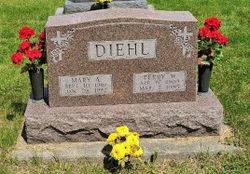
Perry William Diehl
| Birth | : | 17 Apr 1909 Monterey, Highland County, Virginia, USA |
| Death | : | 7 Mar 1995 Osceola, Clarke County, Iowa, USA |
| Burial | : | Ebenezer Particular Baptist Chapel Chapelyard, Bacup, Rossendale Borough, England |
| Coordinate | : | 53.7045700, -2.1997500 |
| Plot | : | Shadowland, Row 36, Headstone 03 |
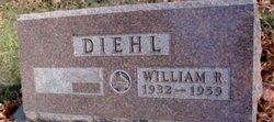
| Inscription | : | DIEHL PERRY W. APR 17, 1909 MAR 7, 1995 |
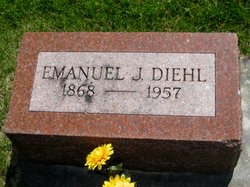
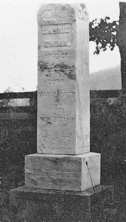
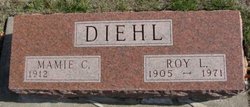
| Description | : | The Osceola Sentinel Tribune, Osceola, Iowa March 16, 1995, Page 3 PERRY WILLIAM DIEHL Perry William Diehl, son of Emmanuel J. and Carrie Hayre (sic) Diehl, was born in Highland County in Virginia on April 17, 1909, and died March 7, 1995, at the Clarke County Hospital in Osceola. He was 85. Mr. Diehl attended Clarke County rural schools and graduated from Osceola High School in 1928. Mr. Diehl, a farmer and avid antique collector, was a member of the Knights of Columbus, Clarke County Historical Society, Agricultural Stabilization Conservation Service Committee in Clarke County, a past... Read More |
frequently asked questions (FAQ):
-
Where is Perry William Diehl's memorial?
Perry William Diehl's memorial is located at: Ebenezer Particular Baptist Chapel Chapelyard, Bacup, Rossendale Borough, England.
-
When did Perry William Diehl death?
Perry William Diehl death on 7 Mar 1995 in Osceola, Clarke County, Iowa, USA
-
Where are the coordinates of the Perry William Diehl's memorial?
Latitude: 53.7045700
Longitude: -2.1997500
Family Members:
Parent
Spouse
Siblings
Children
Flowers:


Nearby Cemetories:
1. Ebenezer Particular Baptist Chapel Chapelyard
Bacup, Rossendale Borough, England
Coordinate: 53.7045700, -2.1997500
2. St John the Evangelist Churchyard
Bacup, Rossendale Borough, England
Coordinate: 53.7037300, -2.2019600
3. Bacup Cemetery
Bacup, Rossendale Borough, England
Coordinate: 53.6906780, -2.2156640
4. Mount Pleasant Wesleyan Chapelyard
Bacup, Rossendale Borough, England
Coordinate: 53.6924900, -2.2228100
5. Saint Anne's Churchyard Edgeside
Waterfoot, Rossendale Borough, England
Coordinate: 53.7031600, -2.2482700
6. Newchurch Methodist Churchyard
Newchurch, Rossendale Borough, England
Coordinate: 53.6983460, -2.2501260
7. Bethlehem Chapel Graveyard
Newchurch, Rossendale Borough, England
Coordinate: 53.6976970, -2.2522620
8. St. Nicholas Churchyard
Newchurch, Rossendale Borough, England
Coordinate: 53.6972220, -2.2524660
9. Saint Michael on the Hill Churchyard
Lumb, Rossendale Borough, England
Coordinate: 53.7201000, -2.2479300
10. Lumb Baptist Church Cemetery
Waterfoot, Rossendale Borough, England
Coordinate: 53.7229340, -2.2455170
11. Cloughfoot Independent Congregational Chapelyard
Todmorden, Metropolitan Borough of Calderdale, England
Coordinate: 53.7113850, -2.1379180
12. Whitworth Cemetery
Whitworth, Rossendale Borough, England
Coordinate: 53.6671650, -2.1674750
13. Mount Zion Methodist Chapleyard
Cornholme, Metropolitan Borough of Calderdale, England
Coordinate: 53.7331400, -2.1457800
14. Friends Burial Ground
Rossendale, Rossendale Borough, England
Coordinate: 53.7091000, -2.2757160
15. Vale Baptist Chapelyard
Cornholme, Metropolitan Borough of Calderdale, England
Coordinate: 53.7321800, -2.1357300
16. St. John the Divine Churchyard
Cliviger, Burnley Borough, England
Coordinate: 53.7533610, -2.1895090
17. Rawtenstall Cemetery
Rawtenstall, Rossendale Borough, England
Coordinate: 53.7060200, -2.2847500
18. Unitarian Chapel Burial Ground
Rossendale, Rossendale Borough, England
Coordinate: 53.7024380, -2.2856290
19. Shore Baptist Chapelyard
Cornholme, Metropolitan Borough of Calderdale, England
Coordinate: 53.7358900, -2.1312700
20. Longholme Methodist Cemetery
Rawtenstall, Rossendale Borough, England
Coordinate: 53.7009730, -2.2865000
21. St Bartholomew Churchyard
Whitworth, Rossendale Borough, England
Coordinate: 53.6553000, -2.1709700
22. Broadleys Garden
Rawtenstall, Rossendale Borough, England
Coordinate: 53.7176321, -2.2904764
23. Burnley Road Cemetery, Reedsholme, Rossendale
Rossendale Borough, England
Coordinate: 53.7178398, -2.2904316
24. Crawshawbooth Quaker Burial Ground
Crawshawbooth, Rossendale Borough, England
Coordinate: 53.7242420, -2.2879400