
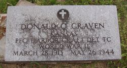
PFC Donald Otto Craven
| Birth | : | 28 Mar 1913 Burlingame, Osage County, Kansas, USA |
| Death | : | 26 May 1944 Adak, Aleutians West Census Area, Alaska, USA |
| Burial | : | Glade Run Cemetery, East Township, Carroll County, USA |
| Coordinate | : | 40.6680984, -80.9642029 |
| Inscription | : | DONALD O CRAVEN KANSAS PFC HARBOR CRAFT DET TC WORLD WAR II MARCH 28 1913--MAY 26 1944 |
| Description | : | Army Service No. (ASN): #37208268 Enlistment Date: 06/16/1942 H Company, 201st Infantry Regiment Donald O. Craven is listed as Died Non-Battle in the 1946 Army and Army Air Forces Personnel Casualty List for Osage County, Kansas. U.S., Headstone Applications for Military Veterans, 1925-1970, lists form signed for by Ethel Craven Hamilton of 117 Lincoln Street, Burlingame, Kansas, on 10/07/1948. Alaska, U.S., Vital Records, 1818-1963, lists a record of death at the 179th Station Hospital in Adak, Alaska on May 26th, 1944, due to tuberculosis. ***I would like to thank Harold Barraclough Find a Grave... Read More |
frequently asked questions (FAQ):
-
Where is PFC Donald Otto Craven's memorial?
PFC Donald Otto Craven's memorial is located at: Glade Run Cemetery, East Township, Carroll County, USA.
-
When did PFC Donald Otto Craven death?
PFC Donald Otto Craven death on 26 May 1944 in Adak, Aleutians West Census Area, Alaska, USA
-
Where are the coordinates of the PFC Donald Otto Craven's memorial?
Latitude: 40.6680984
Longitude: -80.9642029
Family Members:
Parent
Siblings


Flowers:


Nearby Cemetories:
1. Glade Run Cemetery
East Township, Carroll County, USA
Coordinate: 40.6680984, -80.9642029
2. Upper Glade Run Cemetery
Carroll County, USA
Coordinate: 40.6691400, -80.9653910
3. Glade Run Mennonite Church Cemetery
East Township, Carroll County, USA
Coordinate: 40.6760920, -80.9639470
4. Crawford Cemetery
Augusta, Carroll County, USA
Coordinate: 40.6664009, -81.0036011
5. Herrington Bethel Cemetery
Carroll County, USA
Coordinate: 40.6493988, -81.0128021
6. Roudebush Cemetery
Carroll County, USA
Coordinate: 40.7097015, -80.9563980
7. Augusta Christian Church Cemetery
Augusta, Carroll County, USA
Coordinate: 40.6880989, -81.0211029
8. Saint John's Catholic Cemetery
Summitville, Columbiana County, USA
Coordinate: 40.6722984, -80.8980026
9. Snyder Cemetery
Carroll County, USA
Coordinate: 40.6169014, -80.9766998
10. Corinth-Mechanicstown Cemetery
Mechanicstown, Carroll County, USA
Coordinate: 40.6156006, -80.9578018
11. Pattersonville Presbyterian Cemetery
Augusta, Carroll County, USA
Coordinate: 40.6845047, -81.0367607
12. Bird Cemetery
Carroll County, USA
Coordinate: 40.6761017, -81.0406036
13. Bethesda Cemetery
Hanoverton, Columbiana County, USA
Coordinate: 40.7089005, -80.8992004
14. Stillfork Cemetery
Augusta, Carroll County, USA
Coordinate: 40.6720050, -81.0503730
15. Still Fork Church Cemetery
Carroll County, USA
Coordinate: 40.6719017, -81.0505981
16. Quaker Ridge Cemetery
Carroll County, USA
Coordinate: 40.7268982, -81.0119019
17. Mount Zion Cemetery
Augusta, Carroll County, USA
Coordinate: 40.6982994, -81.0492020
18. Stuller Cemetery
Carroll County, USA
Coordinate: 40.6302986, -81.0513992
19. Moore Cemetery
Augusta, Carroll County, USA
Coordinate: 40.7064018, -81.0539017
20. Sandy Springs Cemetery
Hanoverton, Columbiana County, USA
Coordinate: 40.7491989, -80.9561005
21. Arter Methodist Cemetery
Hanoverton, Columbiana County, USA
Coordinate: 40.7467000, -80.9363000
22. Graham Cemetery
Hanoverton, Columbiana County, USA
Coordinate: 40.7491900, -80.9369000
23. Mount Olivet Cemetery
Carroll County, USA
Coordinate: 40.5905991, -81.0081024
24. Grove Hill Cemetery
Hanoverton, Columbiana County, USA
Coordinate: 40.7523300, -80.9423400