
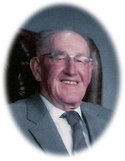
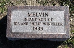
Philip Winckler
| Birth | : | 22 Feb 1909 Bon Homme County, South Dakota, USA |
| Death | : | 10 Oct 2007 Tyndall, Bon Homme County, South Dakota, USA |
| Burial | : | Sunset Lawn Chapel of the Chimes Memorial Park, Sacramento, Sacramento County, USA |
| Coordinate | : | 38.6514816, -121.4384842 |
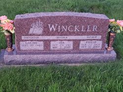
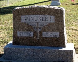
| Description | : | Funeral services for Philip Winckler were held Saturday, Oct. 13, 2007, at Friedens Reformed Church, Tripp, with the Rev. Greg Way officiating. Interment was made in the church cemetery with Goglin Funeral Home, Tyndall and Tripp, in charge of arrangements. Philip Winckler was born on Monday, Feb. 22, 1909, in Bon Homme County to Peter F. and Magdaline (Frey) Winckler. He was baptized May 31, 1909, and confirmed June 29, 1924, in the Congregational Church in Tyndall by the Rev. John Sattler. He was united in marriage to Ida Stoebner on December 17, 1935. They... Read More |
frequently asked questions (FAQ):
-
Where is Philip Winckler's memorial?
Philip Winckler's memorial is located at: Sunset Lawn Chapel of the Chimes Memorial Park, Sacramento, Sacramento County, USA.
-
When did Philip Winckler death?
Philip Winckler death on 10 Oct 2007 in Tyndall, Bon Homme County, South Dakota, USA
-
Where are the coordinates of the Philip Winckler's memorial?
Latitude: 38.6514816
Longitude: -121.4384842
Family Members:
Parent

Spouse

Children
Flowers:


Nearby Cemetories:
1. Kim Quang Temple Columbarium
Sacramento, Sacramento County, USA
Coordinate: 38.5996600, -121.3904700
2. Saint Marks Methodist Church Memorial Tree
Sacramento, Sacramento County, USA
Coordinate: 38.6076500, -121.3750680
3. Holy Ascension Russian Orthodox Cemetery
Sacramento, Sacramento County, USA
Coordinate: 38.5846212, -121.4936736
4. Saint Michaels Episcopal Church Columbarium
Carmichael, Sacramento County, USA
Coordinate: 38.6042800, -121.3547200
5. New Helvetia Cemetery (Defunct)
Sacramento, Sacramento County, USA
Coordinate: 38.5731600, -121.4639900
6. Trinity Episcopal Cathedral Columbarium
Sacramento, Sacramento County, USA
Coordinate: 38.5705500, -121.4723770
7. Union Cemetery
Roseville, Placer County, USA
Coordinate: 38.7302600, -121.3924200
8. California State Capitol
Sacramento, Sacramento County, USA
Coordinate: 38.5760994, -121.4931488
9. Carmichael Presbyterian Church Columbarium
Carmichael, Sacramento County, USA
Coordinate: 38.6179500, -121.3324500
10. East Lawn Memorial Park
Sacramento, Sacramento County, USA
Coordinate: 38.5612960, -121.4492760
11. Sierra Hills Pet Cemetery
Sacramento, Sacramento County, USA
Coordinate: 38.6863500, -121.3305300
12. Sierra Hills Memorial Park
Sacramento, Sacramento County, USA
Coordinate: 38.6843987, -121.3281021
13. National Shrine of Our Lady of Guadalupe Crypt
Sacramento, Sacramento County, USA
Coordinate: 38.5704800, -121.5014400
14. Buddhist Church of Sacramento Nokotsudo
Sacramento, Sacramento County, USA
Coordinate: 38.5639300, -121.4978400
15. Calvary Catholic Cemetery and Mausoleum
Sacramento, Sacramento County, USA
Coordinate: 38.6937180, -121.3233109
16. Saint Joseph Cemetery
Sacramento, Sacramento County, USA
Coordinate: 38.5574989, -121.4835968
17. Sacramento City Cemetery
Sacramento, Sacramento County, USA
Coordinate: 38.5636864, -121.5009537
18. Sunset Hill Cemetery
Sacramento, Sacramento County, USA
Coordinate: 38.5608000, -121.5037300
19. Masonic Lawn Cemetery
Sacramento, Sacramento County, USA
Coordinate: 38.5604720, -121.5032600
20. Odd Fellows Lawn Cemetery and Mausoleum
Sacramento, Sacramento County, USA
Coordinate: 38.5585000, -121.5011000
21. Pho Minh Temple Columbarium
Sacramento, Sacramento County, USA
Coordinate: 38.5340100, -121.4769000
22. Saint Mary's Catholic Cemetery and Mausoleum
Sacramento, Sacramento County, USA
Coordinate: 38.5298900, -121.4261200
23. Sacramento County Hospital Cemetery
Sacramento, Sacramento County, USA
Coordinate: 38.5289300, -121.4239100
24. Fair Oaks Cemetery
Fair Oaks, Sacramento County, USA
Coordinate: 38.6501167, -121.2792000