

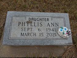
Phyllis Ann Lewis
| Birth | : | 6 Sep 1941 Longford, Clay County, Kansas, USA |
| Death | : | 15 Mar 2021 Pittsburg, Crawford County, Kansas, USA |
| Burial | : | Wesleyan Cemetery, Oak Hill, Clay County, USA |
| Coordinate | : | 39.2268982, -97.2572021 |
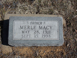
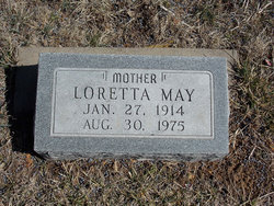
| Description | : | Phyllis Ann Lewis, 79, of Pittsburg, Kansas, formerly of Abilene, Kansas died at 8:48 A.M. Monday, March 15, 2021 at Medicalodges of Pittsburg South. Ms. Lewis was born September 6, 1941 at Longford, Kansas the daughter of Merle M. and Loretta Macy Lewis. Phyllis was a retired school teacher who lived in Abilene, Kansas most of her life until moving to Pittsburg in 2010 to be near her sister. She attended Beach Glenn Grade School and later graduated from Longford Rural High School. She attended Miltonvale Wesleyan College, and later Kansas Wesleyan College, where she received a... Read More |
frequently asked questions (FAQ):
-
Where is Phyllis Ann Lewis's memorial?
Phyllis Ann Lewis's memorial is located at: Wesleyan Cemetery, Oak Hill, Clay County, USA.
-
When did Phyllis Ann Lewis death?
Phyllis Ann Lewis death on 15 Mar 2021 in Pittsburg, Crawford County, Kansas, USA
-
Where are the coordinates of the Phyllis Ann Lewis's memorial?
Latitude: 39.2268982
Longitude: -97.2572021
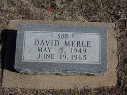
Family Members:
Parent
Siblings
Flowers:


Nearby Cemetories:
1. Wesleyan Cemetery
Oak Hill, Clay County, USA
Coordinate: 39.2268982, -97.2572021
2. Pleasant Valley Cemetery
Oak Hill, Clay County, USA
Coordinate: 39.2468987, -97.2889023
3. Rose Meron Cemetery
Oak Hill, Clay County, USA
Coordinate: 39.2194700, -97.3338900
4. Pleasant Ridge Cemetery
Clay County, USA
Coordinate: 39.2789001, -97.1841965
5. Athelstane Cemetery
Athelstane Township, Clay County, USA
Coordinate: 39.1768990, -97.1753006
6. Table Mound Cemetery
Idana, Clay County, USA
Coordinate: 39.3141300, -97.2792300
7. Hebron Cemetery
Clay County, USA
Coordinate: 39.3213800, -97.2601400
8. Zion Lutheran Cemetery
Clay County, USA
Coordinate: 39.2928009, -97.1557999
9. Mizpah Cemetery
Clay County, USA
Coordinate: 39.2057800, -97.1238500
10. Keystone Cemetery
Manchester, Dickinson County, USA
Coordinate: 39.1185989, -97.2917023
11. Swartwood Cemetery
Longford, Clay County, USA
Coordinate: 39.1323200, -97.3431500
12. Shields Cemetery
Clay County, USA
Coordinate: 39.3208008, -97.3507996
13. Uniondale Cemetery
Wakefield, Clay County, USA
Coordinate: 39.2382800, -97.0918400
14. Idana Cemetery
Idana, Clay County, USA
Coordinate: 39.3574500, -97.2693300
15. Republican City Cemetery
Clay Center, Clay County, USA
Coordinate: 39.3431015, -97.1628036
16. Greenridge Cemetery
Dickinson County, USA
Coordinate: 39.1199989, -97.1433029
17. Mount Liberty Church Cemetery
Ottawa County, USA
Coordinate: 39.2489400, -97.4356200
18. Saint John's Episcopal Cemetery
Clay County, USA
Coordinate: 39.2193985, -97.0744019
19. Henry Cemetery
Buckeye, Dickinson County, USA
Coordinate: 39.0828018, -97.1857986
20. Milo Chapman Gravesite
Broughton, Clay County, USA
Coordinate: 39.2888500, -97.0724400
21. Gilbert Cemetery
Clay County, USA
Coordinate: 39.2853012, -97.0625000
22. Wilson Cemetery
Clay County, USA
Coordinate: 39.3800011, -97.1896973
23. Vine Creek Cemetery
Ottawa County, USA
Coordinate: 39.1194000, -97.4180984
24. White Cloud Cemetery
Manchester, Dickinson County, USA
Coordinate: 39.0744019, -97.3525009