
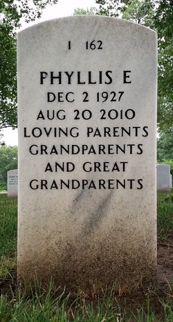
Phyllis E. Beaty Schulte
| Birth | : | 2 Dec 1927 Keokuk, Lee County, Iowa, USA |
| Death | : | 20 Aug 2010 Montrose, Lee County, Iowa, USA |
| Burial | : | St. Mary's Churchyard, Rolleston-on-Dove, East Staffordshire Borough, England |
| Coordinate | : | 52.8465144, -1.6519844 |
| Plot | : | I-0162 |
| Description | : | Dec. 2, 1927 –– Aug. 20, 2010 MONTROSE –– Phyllis E. Schulte, 82, of Montrose died at 8:45 a.m. Friday, Aug. 20, 2010, in Montrose Health Center. She was born on Dec. 2, 1927, in Keokuk, the daughter of Ellrey and Reta Brodsky Beaty. She married William A. Schulte on Dec. 28, 1946, in St. Mary's Catholic Church, Keokuk. He preceded her in death. She attended Sandusky Country School, Torrence Elementary School and Keokuk Junior and Senior High schools, graduating in 1945. Phyllis was a past employee of Thomas Truck and Caster and Montgomery Wards. She was a full-time homemaker... Read More |
frequently asked questions (FAQ):
-
Where is Phyllis E. Beaty Schulte's memorial?
Phyllis E. Beaty Schulte's memorial is located at: St. Mary's Churchyard, Rolleston-on-Dove, East Staffordshire Borough, England.
-
When did Phyllis E. Beaty Schulte death?
Phyllis E. Beaty Schulte death on 20 Aug 2010 in Montrose, Lee County, Iowa, USA
-
Where are the coordinates of the Phyllis E. Beaty Schulte's memorial?
Latitude: 52.8465144
Longitude: -1.6519844
Family Members:
Parent

Spouse
Children
Flowers:


Nearby Cemetories:
1. St. Mary's Churchyard
Rolleston-on-Dove, East Staffordshire Borough, England
Coordinate: 52.8465144, -1.6519844
2. Rolleston Cemetery
Rolleston-on-Dove, East Staffordshire Borough, England
Coordinate: 52.8483757, -1.6643849
3. St Mary's
Marston-on-Dove, South Derbyshire District, England
Coordinate: 52.8633910, -1.6547730
4. Marston-on-Dove Cemetery
Marston-on-Dove, South Derbyshire District, England
Coordinate: 52.8640550, -1.6552780
5. St Mary's Church
Stretton, East Staffordshire Borough, England
Coordinate: 52.8341478, -1.6247215
6. St Mary's Churchyard
Stretton, South Staffordshire Borough, England
Coordinate: 52.8336500, -1.6253400
7. Saint John the Divine Churchyard
Horninglow, East Staffordshire Borough, England
Coordinate: 52.8237520, -1.6426170
8. Priory Church of St. Mary the Virgin
Tutbury, East Staffordshire Borough, England
Coordinate: 52.8590900, -1.6877900
9. St. Wilfrid Churchyard
Egginton, South Derbyshire District, England
Coordinate: 52.8474570, -1.6041750
10. Holy Trinity Churchyard
Anslow, East Staffordshire Borough, England
Coordinate: 52.8216926, -1.7079807
11. St. Paul's Churchyard Extension
Scropton, South Derbyshire District, England
Coordinate: 52.8687230, -1.7133750
12. Garden of Remembrance
Burton upon Trent, East Staffordshire Borough, England
Coordinate: 52.8023045, -1.6283625
13. St Modwen Churchyard
Burton upon Trent, East Staffordshire Borough, England
Coordinate: 52.8013990, -1.6291340
14. RAF Fauld
Hanbury, East Staffordshire Borough, England
Coordinate: 52.8474200, -1.7303500
15. Stapenhill Cemetery
Burton upon Trent, East Staffordshire Borough, England
Coordinate: 52.8026310, -1.6208900
16. St Mark Churchyard
Winshill, East Staffordshire Borough, England
Coordinate: 52.8082040, -1.6048350
17. Saint Helen's Churchyard
Etwall, South Derbyshire District, England
Coordinate: 52.8847700, -1.6017500
18. Etwall Cemetery
Etwall, South Derbyshire District, England
Coordinate: 52.8856100, -1.6025100
19. St. Peter's Parish Churchyard
Stapenhill, East Staffordshire Borough, England
Coordinate: 52.7960899, -1.6230323
20. St Michael Churchyard
Willington, South Derbyshire District, England
Coordinate: 52.8501540, -1.5636540
21. St. Michael and All Angels Churchyard
Tatenhill, East Staffordshire Borough, England
Coordinate: 52.7958170, -1.6968150
22. St Werburgh's Church
Hanbury, East Staffordshire Borough, England
Coordinate: 52.8485000, -1.7478000
23. Saint Saviour's Cemetery
Burton upon Trent, East Staffordshire Borough, England
Coordinate: 52.7892907, -1.6668628
24. St Michael Churchyard
Sutton-on-the-Hill, South Derbyshire District, England
Coordinate: 52.9050080, -1.6484320