


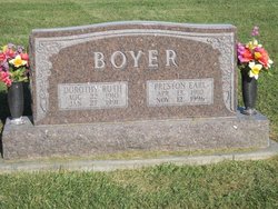
Preston Earl Boyer
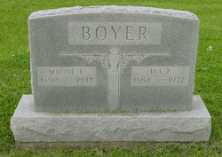
| Birth | : | 13 Apr 1910 Unionville, Appanoose County, Iowa, USA |
| Death | : | 12 Nov 1996 Centerville, Appanoose County, Iowa, USA |
| Burial | : | St. Mary's Churchyard, Nether Stowey, Sedgemoor District, England |
| Coordinate | : | 51.1502280, -3.1494270 |
| Description | : | Earl Boyer, 86, of Moravia died Tuesday. Nov. 12, 1996; at St. Joseph's Mercy Hospital. He was born April 13, 1910, in Unionville, Iowa, the son of Ira and Maude (McDanel) Boyer. He married Dorothy Martindale July 1, 1933. She preceded him in death Jan. 27. 1991. Survivors include two sons. Kenneth Boyer of Rochester, Minn., and Ronald Boyer of Edinburg, 111.; two daughters. Carolyn Stober of Talladega, Ala., and Judy Lamb of Moravia; a sister, Lavern Lundgren of DeSota, Mo.; 10 grandchildren; and 10 great-grandchildren. Also preceding him in death were his parents and a sister. Opal Pearson. • He was a farmer and a member of Drake-Avenue Christian Church in Centerville. He helped organize the Chariton Valley Rural Co-op and served... Read More |
frequently asked questions (FAQ):
-
Where is Preston Earl Boyer's memorial?
Preston Earl Boyer's memorial is located at: St. Mary's Churchyard, Nether Stowey, Sedgemoor District, England.
-
When did Preston Earl Boyer death?
Preston Earl Boyer death on 12 Nov 1996 in Centerville, Appanoose County, Iowa, USA
-
Where are the coordinates of the Preston Earl Boyer's memorial?
Latitude: 51.1502280
Longitude: -3.1494270
Family Members:
Parent

Spouse
Flowers:


Nearby Cemetories:
1. St. Mary's Churchyard
Nether Stowey, Sedgemoor District, England
Coordinate: 51.1502280, -3.1494270
2. Nether Stowey Cemetery
Nether Stowey, Sedgemoor District, England
Coordinate: 51.1498667, -3.1530087
3. Over Stowey Cemetery
Over Stowey, Sedgemoor District, England
Coordinate: 51.1404020, -3.1661850
4. St Peter and St Paul Churchyard
Over Stowey, Sedgemoor District, England
Coordinate: 51.1399680, -3.1656040
5. St. Martin's Churchyard
Fiddington, Sedgemoor District, England
Coordinate: 51.1591640, -3.1229530
6. All Saints Churchyard
Dodington, West Somerset District, England
Coordinate: 51.1583770, -3.1854620
7. Stogursey Extension Cemetery
Stogursey, West Somerset District, England
Coordinate: 51.1793740, -3.1398040
8. St Andrew Churchyard
Stogursey, West Somerset District, England
Coordinate: 51.1795900, -3.1392800
9. St. Mary's Churchyard
Stringston, West Somerset District, England
Coordinate: 51.1748960, -3.1795460
10. Saint Margaret's Churchyard
Spaxton, Sedgemoor District, England
Coordinate: 51.1273090, -3.1087000
11. Spaxton Extension Cemetery
Spaxton, Sedgemoor District, England
Coordinate: 51.1267650, -3.1082920
12. All Saints Churchyard
Aisholt, Sedgemoor District, England
Coordinate: 51.1142070, -3.1532890
13. St. Mary's Churchyard
Holford, West Somerset District, England
Coordinate: 51.1627900, -3.2074238
14. Burton Baptist Chapel
Stogursey, West Somerset District, England
Coordinate: 51.1910560, -3.1560340
15. Charlynch Church of Saint Mary
Spaxton, Sedgemoor District, England
Coordinate: 51.1342600, -3.0879100
16. St. Nicholas's Churchyard
Holford, West Somerset District, England
Coordinate: 51.1902700, -3.1949170
17. Cannington Cemetery
Cannington, Sedgemoor District, England
Coordinate: 51.1500620, -3.0697070
18. St.Mary Magdalene
Stockland Bristol, Sedgemoor District, England
Coordinate: 51.1867260, -3.0886950
19. St. Andrew's Churchyard
Lilstock, West Somerset District, England
Coordinate: 51.1971070, -3.1936420
20. All Saints Churchyard
Otterhampton, Sedgemoor District, England
Coordinate: 51.1829540, -3.0796420
21. Blessed Virgin Mary Churchyard
Cannington, Sedgemoor District, England
Coordinate: 51.1500970, -3.0622850
22. Otterhampton Extension Cemetery
Otterhampton, Sedgemoor District, England
Coordinate: 51.1828490, -3.0791630
23. St. Michael's Churchyard
Enmore, Sedgemoor District, England
Coordinate: 51.1110830, -3.0872790
24. Holy Ghost Churchyard
Crowcombe, West Somerset District, England
Coordinate: 51.1232260, -3.2293260