
| Birth | : | 11 May 1835 Greene County, Ohio, USA |
| Death | : | 22 Aug 1919 Montezuma, Poweshiek County, Iowa, USA |
| Burial | : | Everton Cemetery, Everton, Metropolitan Borough of Liverpool, England |
| Coordinate | : | 53.4555430, -2.9442480 |
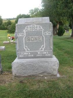
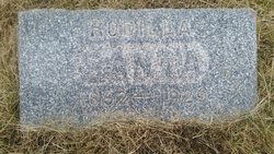
| Description | : | Wife of Thomas Bone. Mother of William. daughter of Thomas and Rhodilla Mendenhall Beason. On March 25,1852 Rachel married Thomas Bone in Powesheik County, Iowa.To this union eight children were born. |
frequently asked questions (FAQ):
-
Where is Rachel Mendenhall Beason Bone's memorial?
Rachel Mendenhall Beason Bone's memorial is located at: Everton Cemetery, Everton, Metropolitan Borough of Liverpool, England.
-
When did Rachel Mendenhall Beason Bone death?
Rachel Mendenhall Beason Bone death on 22 Aug 1919 in Montezuma, Poweshiek County, Iowa, USA
-
Where are the coordinates of the Rachel Mendenhall Beason Bone's memorial?
Latitude: 53.4555430
Longitude: -2.9442480
Family Members:
Parent

Spouse
Siblings
Children
Flowers:


Nearby Cemetories:
1. Everton Cemetery
Everton, Metropolitan Borough of Liverpool, England
Coordinate: 53.4555430, -2.9442480
2. Long Lane Jewish Cemetery
Liverpool, Metropolitan Borough of Liverpool, England
Coordinate: 53.4550140, -2.9420480
3. Rice Lane Jewish Cemetery
Walton, Metropolitan Borough of Liverpool, England
Coordinate: 53.4521700, -2.9590600
4. Kirkdale Cemetery
Liverpool, Metropolitan Borough of Liverpool, England
Coordinate: 53.4672530, -2.9479800
5. Walton Park Cemetery
Walton, Metropolitan Borough of Liverpool, England
Coordinate: 53.4564370, -2.9695960
6. St Mary the Virgin Churchyard
Walton, Metropolitan Borough of Liverpool, England
Coordinate: 53.4464930, -2.9673330
7. West Derby Cemetery
West Derby, Metropolitan Borough of Liverpool, England
Coordinate: 53.4513790, -2.9154630
8. West Derby Jewish Cemetery
Liverpool, Metropolitan Borough of Liverpool, England
Coordinate: 53.4504986, -2.9137393
9. Aintree Racecourse Grounds
Aintree Village, Metropolitan Borough of Sefton, England
Coordinate: 53.4733880, -2.9549700
10. St Luke Churchyard
Walton, Metropolitan Borough of Liverpool, England
Coordinate: 53.4396910, -2.9671400
11. Anfield Cemetery and Crematorium
Anfield, Metropolitan Borough of Liverpool, England
Coordinate: 53.4354680, -2.9578100
12. Bootle Cemetery
Bootle, Metropolitan Borough of Sefton, England
Coordinate: 53.4627680, -2.9787450
13. St Swithins Churchyard
Liverpool, Metropolitan Borough of Liverpool, England
Coordinate: 53.4585631, -2.9012280
14. Kirkdale Goal Cemetery
Kirkdale, Metropolitan Borough of Liverpool, England
Coordinate: 53.4361110, -2.9802780
15. St. Mary's Cemetery
Kirkdale, Metropolitan Borough of Liverpool, England
Coordinate: 53.4323690, -2.9752500
16. St. Alexander Church
Bootle, Metropolitan Borough of Sefton, England
Coordinate: 53.4401090, -2.9922250
17. Green Lane Jewish Cemetery
Liverpool, Metropolitan Borough of Liverpool, England
Coordinate: 53.4234720, -2.9280170
18. St. Mary's Churchyard
Bootle, Metropolitan Borough of Sefton, England
Coordinate: 53.4492620, -3.0006520
19. St. George Churchyard
Everton, Metropolitan Borough of Liverpool, England
Coordinate: 53.4252810, -2.9713940
20. Ford Cemetery
Ford, Metropolitan Borough of Sefton, England
Coordinate: 53.4824040, -2.9925980
21. St. Anthony's Churchyard
Liverpool, Metropolitan Borough of Liverpool, England
Coordinate: 53.4223190, -2.9815350
22. Saint Anne Churchyard
Stanley, Metropolitan Borough of Liverpool, England
Coordinate: 53.4158800, -2.9238300
23. Melling Churchyard
Melling, Metropolitan Borough of Sefton, England
Coordinate: 53.4953370, -2.9228780
24. St. Chad Churchyard
Kirkby, Metropolitan Borough of Knowsley, England
Coordinate: 53.4842890, -2.8930700