
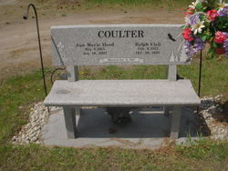
Ralph Clell Coulter
| Birth | : | 8 Feb 1912 Marshall County, Iowa, USA |
| Death | : | 26 Oct 1995 Twin Falls, Twin Falls County, Idaho, USA |
| Burial | : | Chocksett Burial Ground, Sterling, Worcester County, USA |
| Coordinate | : | 42.4377000, -71.7555400 |
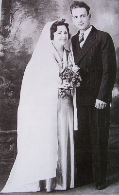
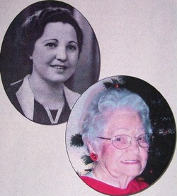
| Description | : | Ralph Clell Coulter was the fourth of 11 children of Archie Aaron Coulter & Ollie Fay Kurtz. His middle name was after his mother's youngest brother, Clell Puterbaugh Kurtz, who was ten years his senior. Ralph married on 9 October, 1937 at Polson, Montana, to Ann Marie Hood (see her listing), the daughter of Frank Hood & Elizabeth "Bessie" Gagnon. Four daughters: Cecile Marie, Mary Shilleen "Shilleen," Virginia Anne, and Anne Lamay "Lamay." |
frequently asked questions (FAQ):
-
Where is Ralph Clell Coulter's memorial?
Ralph Clell Coulter's memorial is located at: Chocksett Burial Ground, Sterling, Worcester County, USA.
-
When did Ralph Clell Coulter death?
Ralph Clell Coulter death on 26 Oct 1995 in Twin Falls, Twin Falls County, Idaho, USA
-
Where are the coordinates of the Ralph Clell Coulter's memorial?
Latitude: 42.4377000
Longitude: -71.7555400
Family Members:
Parent
Spouse
Siblings


Children
Flowers:


Nearby Cemetories:
1. Chocksett Burial Ground
Sterling, Worcester County, USA
Coordinate: 42.4377000, -71.7555400
2. Hillside Cemetery
Sterling, Worcester County, USA
Coordinate: 42.4410000, -71.7492570
3. Oak Hill Cemetery
Sterling, Worcester County, USA
Coordinate: 42.4417000, -71.7493973
4. West Cemetery
Sterling, Worcester County, USA
Coordinate: 42.4514100, -71.7651400
5. Fairbank Burial Ground
Sterling, Worcester County, USA
Coordinate: 42.4152600, -71.7320000
6. Cookshire Cemetery
Sterling, Worcester County, USA
Coordinate: 42.4108500, -71.7734800
7. Saint John's Cemetery
Lancaster, Worcester County, USA
Coordinate: 42.4328003, -71.6977997
8. Reservoir Pines Cemetery
Clinton, Worcester County, USA
Coordinate: 42.4084900, -71.7109700
9. Thayer Cemetery
Lancaster, Worcester County, USA
Coordinate: 42.4578500, -71.7024400
10. Legg Cemetery
Sterling, Worcester County, USA
Coordinate: 42.4070020, -71.7986150
11. Woodlawn Cemetery
Clinton, Worcester County, USA
Coordinate: 42.4185982, -71.6889038
12. Saint Lukes Cemetery
West Boylston, Worcester County, USA
Coordinate: 42.3833008, -71.7568970
13. High Plains Cemetery
West Boylston, Worcester County, USA
Coordinate: 42.3889008, -71.7972031
14. Middle Cemetery
Lancaster, Worcester County, USA
Coordinate: 42.4491997, -71.6757965
15. Parker II Cemetery
Princeton, Worcester County, USA
Coordinate: 42.4451900, -71.8370600
16. Old Settlers Burial Yard
Lancaster, Worcester County, USA
Coordinate: 42.4488754, -71.6742706
17. North Village Cemetery
Lancaster, Worcester County, USA
Coordinate: 42.4724998, -71.6778030
18. Old Common Burial Ground
Lancaster, Worcester County, USA
Coordinate: 42.4426700, -71.6645300
19. Beaman Cemetery
West Boylston, Worcester County, USA
Coordinate: 42.3649590, -71.7803600
20. Eastwood Cemetery
Lancaster, Worcester County, USA
Coordinate: 42.4417000, -71.6528015
21. Mount Vernon Cemetery
West Boylston, Worcester County, USA
Coordinate: 42.3634650, -71.7804030
22. Saint Leo Cemetery
Leominster, Worcester County, USA
Coordinate: 42.5153008, -71.7472000
23. Pine Grove Cemetery
Boylston, Worcester County, USA
Coordinate: 42.3582993, -71.7431030
24. Saint Cecilias Cemetery
Leominster, Worcester County, USA
Coordinate: 42.5166800, -71.7331900