

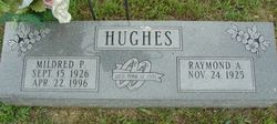
Raymond Arthur Hughes
| Birth | : | 24 Nov 1925 |
| Death | : | 12 Feb 2013 |
| Burial | : | St. Chad Churchyard, Uppermill, Metropolitan Borough of Oldham, England |
| Coordinate | : | 53.5542570, -1.9901190 |
| Inscription | : | Wed. Mar. 12, 1951 |
| Description | : | Raymond Arthur Hughes, 87, of Birch Tree, MO, passed away on February 12, 2013 in his home surrounded by loved ones. He was the son of Arthur and Hazel Reed Hughes born on November 24, 1925. He was proud to have served in the United States Navy and defended his country in both the Korean and World War II. He held great pride in his service and believed in flying his American flag daily in a show of support to his country. Ray was married to his best friend and partner of 14 years, Geneva Iline Allen on... Read More |
frequently asked questions (FAQ):
-
Where is Raymond Arthur Hughes's memorial?
Raymond Arthur Hughes's memorial is located at: St. Chad Churchyard, Uppermill, Metropolitan Borough of Oldham, England.
-
When did Raymond Arthur Hughes death?
Raymond Arthur Hughes death on 12 Feb 2013 in
-
Where are the coordinates of the Raymond Arthur Hughes's memorial?
Latitude: 53.5542570
Longitude: -1.9901190
Family Members:
Spouse
Children


Nearby Cemetories:
1. St. Chad Churchyard
Uppermill, Metropolitan Borough of Oldham, England
Coordinate: 53.5542570, -1.9901190
2. Delph Independent Chapelyard
Delph, Metropolitan Borough of Oldham, England
Coordinate: 53.5690839, -2.0225845
3. St Thomas Churchyard Friarmere
Delph, Metropolitan Borough of Oldham, England
Coordinate: 53.5778800, -2.0285500
4. Christ Church Churchyard
Denshaw, Metropolitan Borough of Oldham, England
Coordinate: 53.5918070, -2.0385720
5. St. John The Baptist Churchyard
Oldham, Metropolitan Borough of Oldham, England
Coordinate: 53.5424690, -2.0680150
6. St. John the Baptist Churchyard
Heybridge, Central Coast Council, Australia
Coordinate: 53.5415973, -2.0699727
7. Holy Trinity Churchyard
Waterhead, Metropolitan Borough of Oldham, England
Coordinate: 53.5507100, -2.0738400
8. St. George Parish Churchyard
Mossley, Metropolitan Borough of Tameside, England
Coordinate: 53.5164000, -2.0486200
9. Mossley Cemetery
Mossley, Metropolitan Borough of Tameside, England
Coordinate: 53.5092100, -2.0332700
10. St Thomas'
Oldham, Metropolitan Borough of Oldham, England
Coordinate: 53.5366318, -2.0724053
11. Greenacres Congregational Church
Oldham, Metropolitan Borough of Oldham, England
Coordinate: 53.5455200, -2.0788100
12. Lees Cemetery
Oldham, Metropolitan Borough of Oldham, England
Coordinate: 53.5347540, -2.0739260
13. Greenacres Cemetery
Oldham, Metropolitan Borough of Oldham, England
Coordinate: 53.5455490, -2.0820510
14. St Bartholomew Churchyard
Marsden, Metropolitan Borough of Kirklees, England
Coordinate: 53.6010890, -1.9294800
15. Second Anglican Chapel in Marsden
Marsden, Metropolitan Borough of Kirklees, England
Coordinate: 53.6010690, -1.9290030
16. Buckley Hill Chapel
Marsden, Metropolitan Borough of Kirklees, England
Coordinate: 53.6019430, -1.9274970
17. Holy Trinity Churchyard
Shaw, Metropolitan Borough of Oldham, England
Coordinate: 53.5749940, -2.0991780
18. Friends Burial Ground at Turf Lane
Royton, Metropolitan Borough of Oldham, England
Coordinate: 53.5620200, -2.1039660
19. Crompton Cemetery
Shaw, Metropolitan Borough of Oldham, England
Coordinate: 53.5799840, -2.1003410
20. Hurst Cemetery
Ashton-Under-Lyne, Metropolitan Borough of Tameside, England
Coordinate: 53.5011590, -2.0727370
21. St. Mary Church of England Churchyard
Oldham, Metropolitan Borough of Oldham, England
Coordinate: 53.5428030, -2.1104030
22. St Paul Churchyard
Stalybridge, Metropolitan Borough of Tameside, England
Coordinate: 53.4852000, -2.0440300
23. St. John the Evangelist Churchyard
Hurst, Metropolitan Borough of Tameside, England
Coordinate: 53.5001310, -2.0812490
24. St Georges Cemetery
Stalybridge, Metropolitan Borough of Tameside, England
Coordinate: 53.4873400, -2.0576800